

























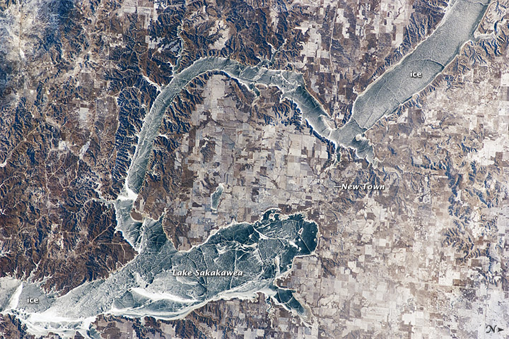
This photograph taken by an astronaut on the International Space Station illustrates the harsh winter conditions frequently experienced in North Dakota. Ice covers the surface of northwestern Lake Sakakawea, a reservoir on the Missouri River. A local weather station near New Town, North Dakota, reported an air temperature of -24°C (-11°F), with a wind chill of approximately -32°C (-25°F) at 10:36 a.m. local time—six minutes before the image was taken. In addition to the grey ice on the lake, a dusting of white snow highlights the agricultural fields to the north and northeast, as well as fissures and irregularities in the ice surfaces. For a sense of scale, the arms of the lake to either side of New Town are approximately 10 kilometers (6 miles) apart.
Lake Sakakawea is named—in the Hidatsa language—for the Shoshone woman generally known as Sacagawea, or “Bird Woman.” In 1805 –1806, she accompanied the Lewis and Clark Expedition as an interpreter and guide.
The lake was created in 1954 following the completion of Garrison Dam (not shown) on the Missouri River. With a surface area of approximately 148,924 hectares (368,000 acres) and length of 286 kilometers (178 miles), Lake Sakakawea is one of the largest artificial reservoirs in the United States.
References & Resources
Astronaut photograph ISS030-E-59433 was acquired on January 19, 2012, with a Nikon D2Xs digital camera using a 180 mm lens, and is provided by the ISS Crew Earth Observations experiment and Image Science & Analysis Laboratory, Johnson Space Center. The image was taken by the Expedition 30 crew. The image has been cropped and enhanced to improve contrast, and lens artifacts have been removed. The International Space Station Program supports the laboratory as part of the ISS National Lab to help astronauts take pictures of Earth that will be of the greatest value to scientists and the public, and to make those images freely available on the Internet. Additional images taken by astronauts and cosmonauts can be viewed at the NASA/JSC Gateway to Astronaut Photography of Earth. Caption by William L. Stefanov, Jacobs/ESCG at NASA-JSC.