


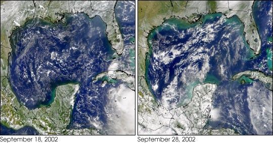
These two Sea-viewing Wide Field-of-view Sensor (SeaWiFS) images were collected ten days apart. The first was collected onSeptember 18, 2002, before Hurricane Isidore blew through. Part ofthe cloud field associated with Isidoreis visible in the lower right corner ofthe left-hand frame.
The second image—collected on September 28, 2002—shows a marked increase in the albedo of the coastal waters, particularly in the northern Gulf of Mexico. This ‘brightening’ of the sea water is most likely caused by increased wave action associated with the passing storm and increased rainwater runoff from the land. Both of these processesentrain more suspended sediments in the water column which, in turn, make the water reflect a greater percentage of the incoming sunlight.
The cloud pattern in the lower right corner of the right-hand image is part of Tropical Storm Lili. Lili, now a hurricane, is currently forecast to follow a path similar to Isidore’s the week before.
References & Resources
Image courtesy the SeaWiFS Project, NASA/Goddard Space Flight Center, and ORBIMAGE


