


On most days, South Australia’s Lake Torrens shows up in satellite images as a relatively dry salt and mud flat. But in October 2022, a substantial amount of water returned to this ephemeral lake.
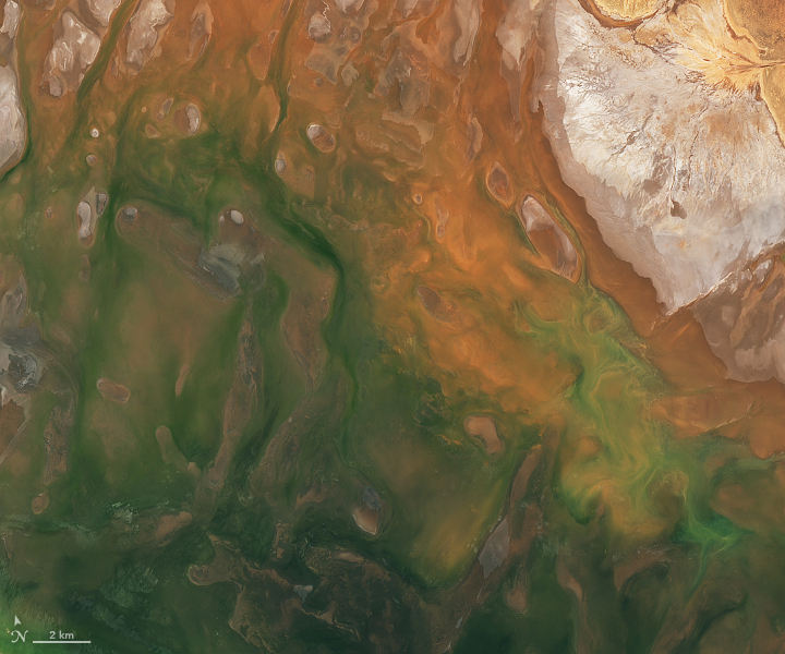
The Operational Land Imager-2 (OLI-2) on Landsat 9 acquired these images on October 28, 2022, when water spanned much of the lakebed. Wet areas are green-brown, salty surfaces are white, and land is red-brown.
Lake Torrens is located within in the east-central part of South Australia, just over 100 kilometers (60 miles) south of the Lake Eyre and 450 kilometers (280 miles) north of Adelaide. It lies between the Arcoona Plateau to the west and the Flinders Ranges to the east. The lake arose from a depression that formed east of the Torrens Fault about 70 million years ago. Today, it is one of Australia’s largest inland salt lakes, and is a sacred site to nearby Aboriginal nations.
The region is generally very dry, averaging only a few hundred millimeters of rain each year. Unlike Lake Eyre, which receives most of its water from runoff during the summer monsoon, water in Lake Torrens depends primarily on rainfall from the southern hemisphere westerlies during winter.
Across South Australia, an unusually wet winter in 2022 has extended into spring, with the state seeing its wettest October on record (since 1900). Some areas, including the Flinders district, received more than 100 millimeters (4 inches) of rain, making it the wettest October on record. Areas around Roxby Downs, about 30 kilometers southwest of Andamooka, recorded more than eight times their average monthly rainfall for October.
Lake Torrens is typically endorheic, which means that the lake has no outflow and instead loses water via evaporation or seepage into the ground. That was probably still the case this year. But on rare occasions, most recently in 1989, extreme rainfall fills the lake with so much water that it flows south across the Pirie-Torrens corridor and into the Spencer Gulf.
References & Resources
- ABC News (2022, October 10) Bureau of Meteorology severe weather outlook. What does it mean for each state and territory? Accessed November 4, 2022.
- ABC News (2022, September 27) Indigenous sacred site Lake Torrens faces exploratory drilling for resources. Accessed November 4, 2022.
- Australian Government Bureau of Meteorology (2022, November 2) South Australia in October 2022: very wet with cool days, warm nights in the south-east. Accessed November 4, 2022.
- Bye, J. et al. (2015) The major flooding of Lake Torrens in March 1989. Transactions of the Royal Society of South Australia, 139 (2), 171-188.
- Koch, B. A. (2016) Lunette dunes of Lake Torrens and their significance as paleoenvironmental indicators. University ofAdelaide.
- NASA Earth Observatory (2019, May 28) Rare Filling of Kati Thanda-Lake Eyre. Accessed November 4, 2022.
- National Parks and Wildlife Service, South Australia Lake Torrens National Park. Accessed November 4, 2022.
NASA Earth Observatory images by Lauren Dauphin, using Landsat data from the U.S. Geological Survey . Story by Kathryn Hansen .


