Today’s Image of the Day is derived from our newest feature: Reading the ABCs from Space.
Aloha, A...what begins with A? There is Antarctica and the Arctic, algal blooms, and the atmosphere. And aerosols altering an astronaut’s view of ancient rocks in a state adjacent to Arizona!
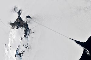
—home to penguins, the Transantarctic Mountains, and a continent-sized sheet of ice—is a huge landmass surrounded by ocean. In contrast, the Arctic is an ocean basin surrounded by land, which means that the
—where polar bears amble—is corralled in the coldest, darkest part of the Northern Hemisphere.Algal blooms have been
, although they are more common in open, ice-free water.
The effect of plankton, however, can sometimes reach beyond the sea and into the atmosphere. These plant-like organisms release organic molecules into their surrounding seawater. This seawater, organic particles and all, can then be lofted into the air as sea spray. Biologically-seeded aerosols can go on to affect clouds and regional climate.
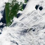
Aerosols also come from anthropogenic sources, such as biomass burning and fossil fuel combustion. For example, large tankers, container ships, and other vessels emit some pollution particles as exhaust; other aerosol pollutants form indirectly as exhaust gases mix and cool in the atmosphere. Water vapor can condense around these tiny particles to form long, narrow clouds known as ship tracks. The image above, acquired on July 27, 2015 with the Moderate Resolution Imaging Spectroradiometer (MODIS) on NASA’s Aqua satellite, shows ship tracks off the Kamchatka Peninsula.
As for the state located adjacent to Arizona? That’s Utah, where awe-inspiring geology abounds. Arches National Park, for example, is home to some 2,000 arches, as well as rock spires and pinnacles. Also in eastern Utah, you will find the Green River winding through tall canyon walls. In some places, the river doubles back on itself, notably at Bowknot Bend. But what transpired to give rise to the aforementioned meander? Read more about the geology in our March 2014 Image of the Day.
Click here to see our entire satellite alphabet gallery.
References & Resources
NASA Earth Observatory image by Jesse Allen, using data from the Level 1 and Atmospheres Active Distribution System (LAADS). Caption by Kathryn Hansen and Adam Voiland.