Editor’s Note: Today’s caption is the answer to Earth Observatory’s October Puzzler.
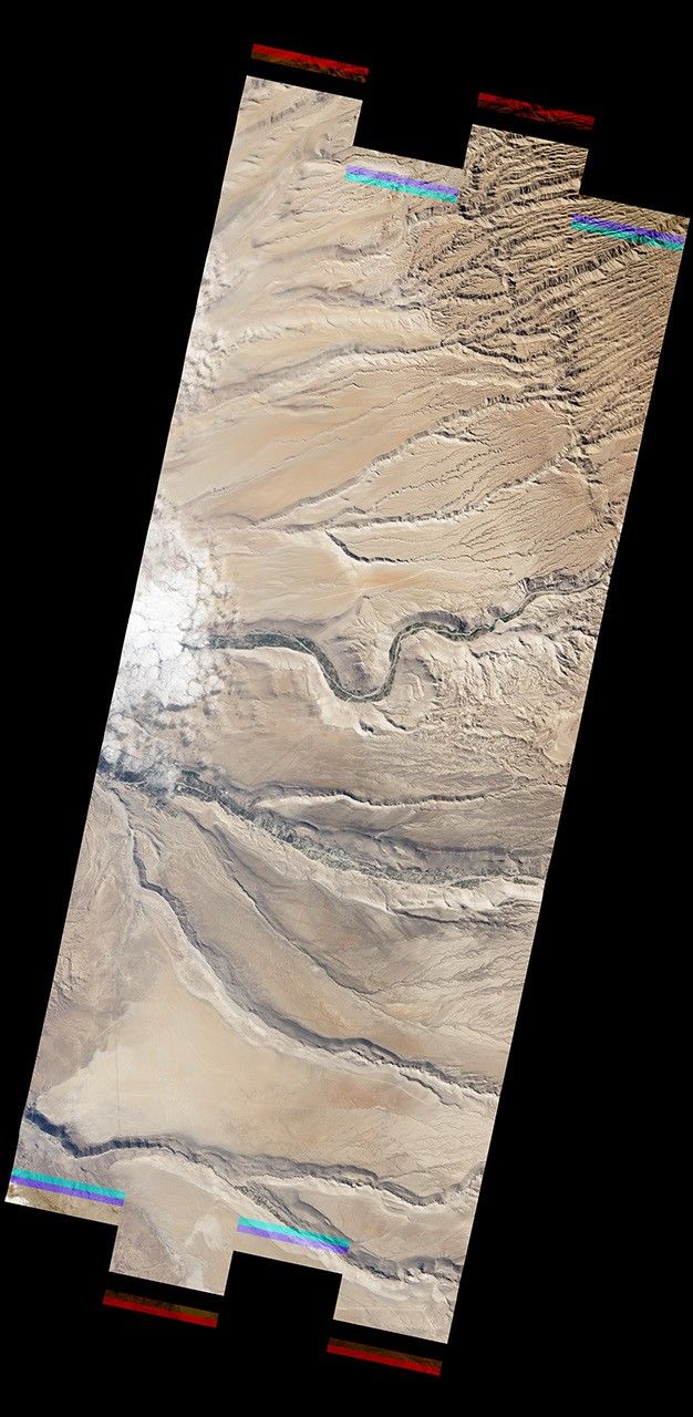
A remote plateau in far northern Chile is not a place you want to be without water. Large sections of the Atacama Desert—often called the driest place on Earth—receive less than a millimeter of rain per year.
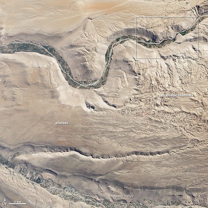
The town of Arica—which lies along the Pacific coast, about 15 miles (24 kilometers) west of the area shown here—has the lowest average precipitation of any city in the world. Arica survives on just .03 inches (0.8 millimeters) of rain per year, about 75 times less than what California’s Death Valley receives.
The barren nature of the landscape was on full display on July 19, 2012, when the Advanced Land Imager (ALI) on NASA’s Earth Observing-1 satellite acquired this image. Although a few types of cacti and other drought-tolerant species can survive in the Atacama, surfaces appear vegetation-free from ALI’s perspective, leaving a veneer of tan to dominate the image.
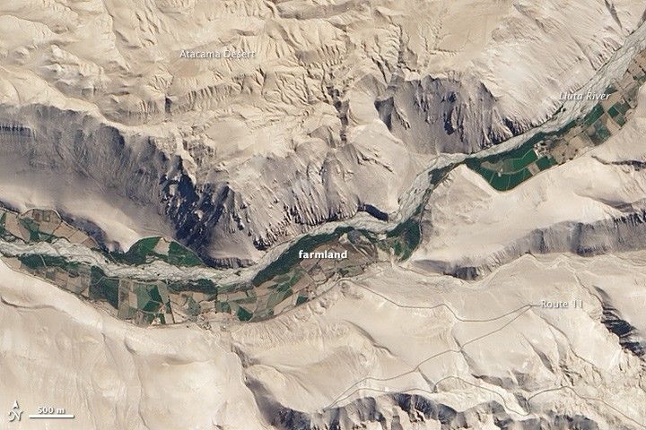
The exceptions, of course, are the explosions of green in the canyons, which were carved by the Lluta and San José rivers. Both rivers flow toward the Pacific Ocean and have headwaters to the east, in the foothills of the Andes. Glaciers on Tacora, a stratovolcano to the northeast, provide enough water for the Lluta to flow year round, making it one of the few rivers in the area that does.
Distinct blocks of green color the bottom of the Lluta and Apaza Valleys, the product of irrigation by residents of the small farming villages nestled in the canyon bottoms. Despite the seemingly lush fields, farmers in the Lluta Valley face serious water quality problems. In addition to being quite saline and acidic, the Lluta River contains dangerously high levels of boron, arsenic, sulfate, and other undesirable substances that flow into the river from natural geothermal springs and upstream mining operations.
Due to the poor water quality, farmers who irrigate with Lluta River water can only use it for pastureland or for a few tolerant crops, such as onions and potatoes. The water woes have left the area struggling economically and reliant on bottled drinking water from the Chilean government. In contrast, the clean waters of the San José River a few kilometers to the south, which carved Apaza Valley, support a broad range of high-quality crops, particularly olives.
The steep slopes, or scarps, that form the Lluta Valley’s walls make reaching the valley floor from the plateau a challenge. Route 11 provides one of the few access points near the village of Churina. The complicated network of drainage channels that join the river from the east lessened the slope on the southern wall, making it easier to build the road.
Water running off a massive amphitheater-shaped scarp a few kilometers east—the product of a giant landslide known as the Lluta Collapse—created the distinctive drainage pattern. The landslide, one of the oldest known slides in the world, occurred at least 2.5 million years ago and displaced 25 cubic kilometers of material.
References & Resources
- Arizona State University World: Longest Recorded Dry Period. Accessed October 31, 2013. World: Longest Recorded Dry Period. Accessed October 31, 2013.
- Goddard Earth Sciences Data and Information Services Center Northern Chile. Accessed October 31, 2013.
- Hoke, G. (2007, October 31) Geomorphic evidence for 1 post–10 Ma uplift of the western flank of the Central Andes 18°30–22°S. Tectonics, 26 (5).
- Kober, F. & Schlunegger, F. (2006, July) Surface uplift and climate change: The geomorphic evolution of the Western Escarpment of the Andes of northern Chile between the Miocene and present. GSA Special Papers, (398) 75-86.
- Northwestern Engineering (2011, September 19) Engineers for a Sustainable World Students Conduct Water Research in Chile. Accessed October 31, 2013.
- Shi, J. et al (2011, September 19) Arsenic and Boron Removal from the Lluta River, Chile. Accessed October 31, 2013.
- Strasser, M. & Schlunegger, F. (2005, July) Erosional processes, topographic length-scales and geomorphic evolution in arid climatic environments: the “Lluta collapse,” in northern Chile. International Journal of Earth Sciences, 94 (30) 43-44.
- Worner, G. (2002, February 15) Evolution of the West Andean Escarpment at 18S (N. Chile) during he last 25 MA: uplift, erosion and collapse through time. Tectonophysics, 345 (1-4) 183-198.
- Window to the Universe Atacama Desert. Accessed October 31, 2013.
NASA Earth Observatory image by Jesse Allen and Robert Simmon, using EO-1 ALI data provided courtesy of the NASA EO-1 team. Caption by Adam Voiland. Congratulations to Jaimen W. for solving the October Puzzler the fastest. Congratulations also to Javier Canete, Alan W, and Juan Pablo Joui for offering some interesting details about the area.