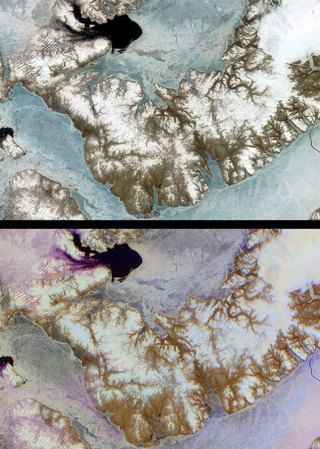


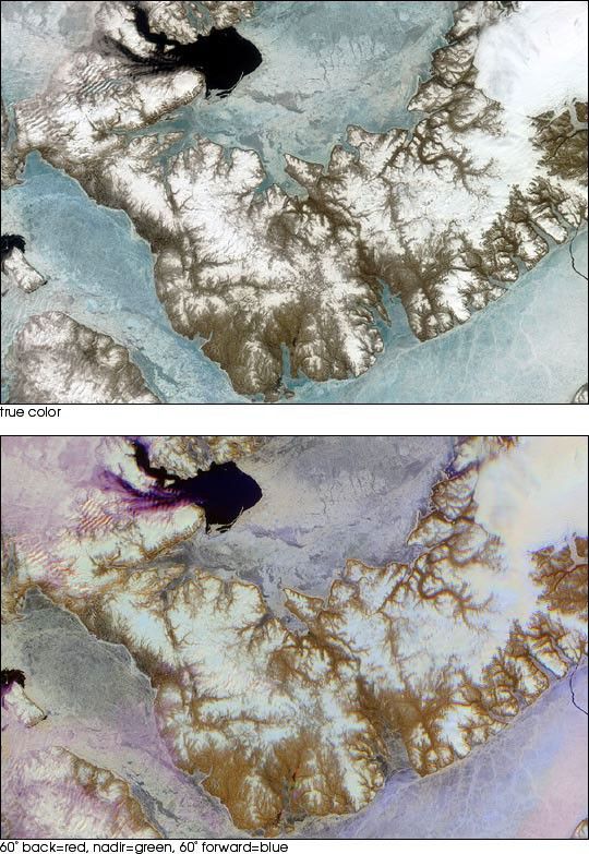
Devon Island is situated in an isolated part of Canada’s Nunavut Territory,and is usually considered to be the largest uninhabited island in the world.However, each summer since 1999, researchers from NASA’s Haughton-Mars Projectand the Mars Society reside at this“polar desert” location to study thegeologic and environmental characteristics of a site which is considered to bean excellent“Mars analog”: a terrestrial location wherein specific conditionsapproximate environmental features reported on Mars. Base camps establishedamidst the rocks and rubble surrounding the Haughton impact crater enableresearchers to conduct surveys designed to test the habitat, equipment andtechnology that may be deployed during a human mission to Mars. One of the manyobjectives of the scientists is to understand the ice formations aroundthe Haughton area, in the hopes that this might ultimately assist with therecognition of areas where ice can be found at shallow depth on Mars.
These images of Devon Island from NASA’s Multi-angle ImagingSpectroRadiometer (MISR) instrument provide contrasting views of the spectraland angular reflectance“signatures” of different surfaces within the region.The top panel is a natural color view created with data from the red, green andblue-bands of MISR’s nadir (vertical-viewing) camera. The bottom panel is afalse-color multiangular composite of the same area, utilizing red band datafrom MISR’s 60-degree backward, nadir, and 60-degree forward-viewing cameras,displayed as red, green and blue, respectively. In this representation, colorshighlight textural properties of elements within the scene, with blue tonesindicating smooth surfaces (which preferentially forward scatter sunlight) andred hues indicating rougher surfaces (which preferentially backscatter). Theangular reflectance“signature” of low clouds causes them to appear purple, andthis visualization provides a unique way of distinguishing clouds from snow andice.
The data were captured on June 28, 2001, during the early part of the arcticsummer, when sea ice becomes thinner and begins to move depending upon localizedcurrents and winds. In winter the entire region is locked with several meters ofnearly motionless sea ice, which acts as a thermodynamic barrier to the loss ofheat from the comparatively warm ocean to the colder atmosphere. Summer meltingof sea ice can be observed at the two large, dark regions of open water; one ispresent in the Jones Sound (near the top to the left of center), and anotherappears in the Wellington Channel (left-hand edge). A large crack caused bytidal heaving has broken the ice cover over the Parry Channel (lower right-handcorner). A substantial ice cap permanently occupies the easternmost third of theisland (upper right). Surface features such as dendritic meltwater channelsincised into the island’s surface are apparent. The Haughton-Mars project siteis located slightly to the left and above image center, in an area which appearswith relatively little surface ice, near the island’s inner“elbow”.
References & Resources
Image courtesy NASA/GSFC/LaRC/JPL, MISR Team.