


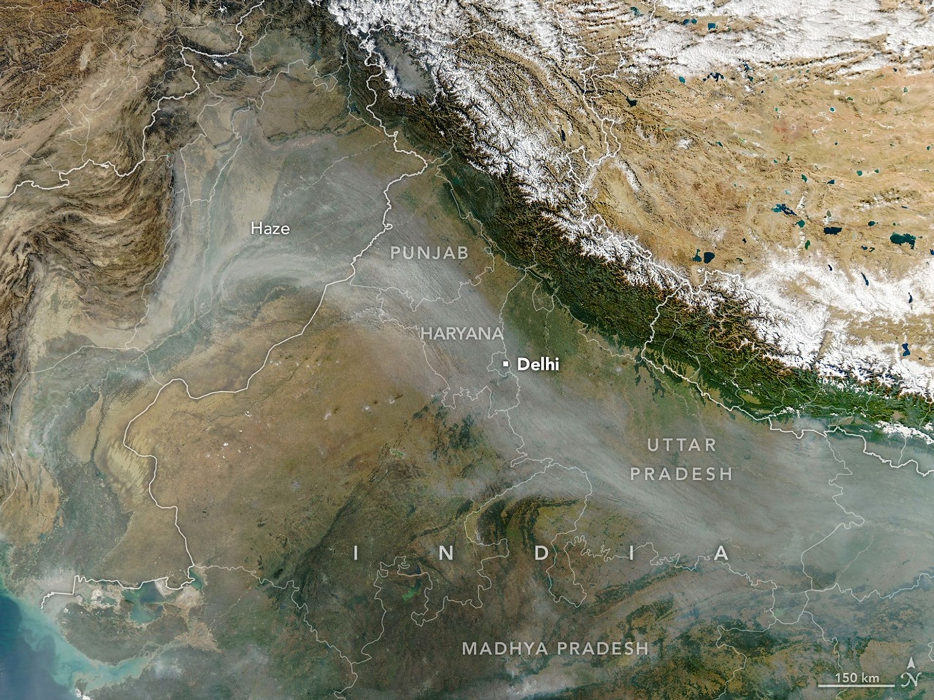
Every year for decades, long rivers of smoke and haze have spread across the Indo-Gangetic Plain in northern India from October to December. That's when farmers in Punjab, Haryana, Uttar Pradesh, Madhya Pradesh, and other states burn off plant "stubble" after the rice harvest.
When winds are weak and the atmosphere becomes stagnant, the haze can push levels of air pollution several times higher than limits recommended by the World Health Organization. Smoke typically mixes with particles and gases from other sources, such as industry, vehicles, domestic fires (heating and cooking), fireworks, and dust storms, to form the haze, though scientists consider stubble burning to be a major factor.
In some ways, the seasonal timing of stubble fires in 2025 followed typical patterns. Air quality deteriorated in Delhi and several other cities for about a month after crop fires intensified during the last week of October, explained Hiren Jethva, a Morgan State University atmospheric scientist based at NASA’s Goddard Space Flight Center. For about a decade, Jethva has tracked the stubble burning season in India using satellites, and has made predictions about the intensity of the upcoming fire season based on vegetation observations.
The MODIS (Moderate Resolution Imaging Spectroradiometer) on NASA's Aqua satellite captured this image of a smoky haze darkening skies over much of the plain on November 11, 2025. According to news reports, it was the first of several days in 2025 when pollution levels exceeded 400 on India's air quality index, the strongest rating on the scale. As in past years, the poor air quality prompted officials in some areas to close schools and institute more stringent air quality controls on construction.
However, the daily timing of burning departs from what Jethva has seen in the past. He started tracking the number of fires years ago by primarily tallying observations from MODIS—which pass over locations on Earth each morning and afternoon on the Terra and Aqua satellites, respectively. Then, most fires were lit in the early afternoon between 1 p.m. and 2 p.m. local time.
But in the past few years, stubble fires have occurred progressively later in the day, Jethva said. He identified the shift by analyzing observations from GEO-KOMPSAT-2A, a South Korean geostationary satellite launched in late 2018 that collects data every 10 minutes.
Most stubble fires now happen between 4 p.m. and 6 p.m., he said, meaning that fire-monitoring systems that rely solely on MODIS, or similar sensors like VIIRS (Visible Infrared Imaging Radiometer Suite), miss many of the fires. "Farmers have changed their behavior," he said.
His analysis of GEO-KOMPSAT-2A observations indicates that the stubble burning activity in Punjab and Haryana was moderate in 2025 compared to other recent years. This year had higher numbers of fires compared to 2024, 2020, and 2019 but fewer fires than 2023, 2022, and 2021, he found.
Indian Space Research Organization researchers have also pointed out the shift in the timing of stubble burning. In a Current Science study published in 2025, one group reported that MSG (Meteosat Second Generation) satellite observations showed a shift in peak fire activity from about 1:30 p.m. in 2020 to about 5:00 p.m. in 2024. In December 2025, researchers with the International Forum for Environment, Sustainability, & Technology (iForest) released a multi-satellite analysis that came to a similar conclusion.
Meanwhile, parsing out precisely how much stubble fires contribute to poor air quality in Delhi compared to other sources of pollution remains a topic of active study and debate among scientists. "Studies report contributions ranging from 10 to 50 percent," said Pawan Gupta, a NASA research scientist who specializes in air quality.
Gupta estimates that the stubble burning contribution ranges from 40 to 70 percent on a given day, dropping to 20 to 30 percent if averaged over a month or burning season, and under 10 percent if averaged annually. "Meteorological conditions—like a shallow boundary layer height and low temperature—during the burning season add extra complexity," he said.
The timing of the fires may influence the degree to which stubble burning affects air quality. Some modeling research suggests that evening fires may lead to a stronger overnight buildup of particle pollution than early-afternoon fires because the planetary boundary layer, the lowest part of the atmosphere, tends to be shallower and have weaker winds at night, allowing pollutants to accumulate.
NASA Earth Observatory image by Michala Garrison, using MODIS data from NASA EOSDIS LANCE and GIBS/Worldview. Story by Adam Voiland.
References and Resources
- Biswal, A., et al. (2025) Emission time and amount of crop residue burning play critical role on PM2.5 variability during October–November in northwestern India during 2022–2024. Environmental Science: Atmospheres, 11.
- Burki, T. (2025) Stubble: The Farmer's Bane. The Lancet Respiratory Medicine, 13(2), 207.
- The Deccan Herald (2025, December 8) Punjab, Haryana farmers change stubble burning time window to avoid satellite detection. Accessed December 9, 2025.
- Down to Earth (2025, November 26) Why has Madhya Pradesh burnt more paddy stubble for the second year in a row? Accessed December 9, 2025.
- Jethva, H., et al. (2019) Connecting Crop Productivity, Residue Fires, and Air Quality over Northern India. Scientific Reports, 9, 16594.
- Ministry of Environment, Forest and Climate Change (2025, December 1) Paddy Harvesting Season 2025 concludes with significant Reduction in Farm Fire Incidents across Punjab and Haryana. Accessed December 9, 2025.
- NASA (2024, October 18) What is Air Quality? Accessed December 9, 2025.
- NASA Earth Observatory (2020, November 17) A Busy Season for Crop Fires in Northwestern India. Accessed December 9, 2025.
- NASA Earth Observatory (2025, January 22) Is Fire Activity Declining in Northwestern India? Accessed December 9, 2025.
- NDTV (2025, December 1) Stubble Burning Down By 90% In Punjab, Haryana, Centre Informs Parliament. Accessed December 9, 2025.
- NDTV (2025, December 9) Farm Fires Didn't End, They Just Moved To Afternoon: Satellite Data Analysis. Accessed December 9, 2025.
- The New Indian Express (2025, November 11) AQI spikes to 428 in first ‘severe’ air day of this year, GRAP-III invoked in capital. Accessed December 9, 2025.
- Singh, N., et al. (2025) Evidence of shift in stubble burning timing over northwest India from geostationary satellite observations. Current Science, 129(10), 921-923.
- The Times of India (2025, December 6) Stubble burning cases jump by 18% in UP this year. Accessed December 9, 2025.


