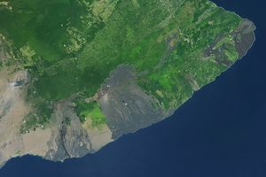


The Nyiragongo volcano in Congo erupted on January 17, 2002, andsubsequently sent streams of lava into the city of Goma on the northshore of Lake Kivu. More than 100 people were killed, more than 12,000homes were destroyed, and hundreds of thousands were forced to flee thebroader community of nearly half a million people.
This computer-generated visualization combines a Landsat satelliteimage and an elevation model from the Shuttle Radar Topography Mission(SRTM) to provide a view of both the volcano and the city of Goma,looking slightly east of north. Additionally, image data from theAdvanced Spaceborne Thermal Emission and Reflection Radiometer (ASTER)on NASA's Terra satellite were used to supply a partial map of therecent lava flows (red), including a complete mapping of their intrusioninto Goma as of January 28, 2002. Lava is also apparent within thevolcanic crater and at a few other locations. Thick (but broken) cloudcover during the ASTER image acquisition prevented a complete mapping ofthe lava distribution, but future image acquisitions should complete themapping.
Nyiragongo is the steep volcano on the right, Lake Kivu is in theforeground, and the city of Goma has a light pink speckled appearancealong the shoreline. Nyiragongo peaks at about 3,470 meters (11,380feet) elevation and reaches almost exactly 2,000 meters (6,560 feet)above Lake Kivu. The shorter but broader Nyamuragira volcano appears inthe left background. Topographic expression has been exaggeratedvertically by a factor of 1.5 for this visualization.
Goma, Lake Kivu, Nyiragongo, Nyamuragira and other nearby volcanoessit within the East African Rift Valley, a zone where tectonic processesare cracking, stretching, and lowering the earth's crust. Volcanicactivity is common here, and older but geologically recent lava flows(magenta in this depiction) are particularly apparent on the flanks ofthe Nyamuragira volcano. The Landsat image used here was acquired onDecember 11, 2001, about a month before the eruption, and shows anunusually cloud-free view of this tropical terrain. Minor clouds andtheir shadows were digitally removed to clarify the view, topographicshading derived from the SRTM elevation model was added to the Landsatimage, and a false sky was added.
Size: View width 21 kilometers (13 miles), View distance 42 kilometers (26 miles)
Location: 1.5 degrees South latitude, 29.3 degrees East longitude
Orientation: View east-northeast, 5 degrees below horizontal
Image Data: Landsat Bands 3, 2, 1 as red, green, blue, respectively. ASTER Band 12 (thermal) shown as red overlay.
Original Data Resolution: SRTM 1 arcsecond (30 meters or 98 feet), Landsat 30 meters (98 feet). ASTER (thermal) 90 meters (295 feet).
Date Acquired: February 2000 (SRTM), December 11, 2001 (Landsat), January 28, 2002 (ASTER)
For other views of Nyiragongo, visit Space Images Show Extent of Congo VolcanoDevastation
References & Resources
Image Courtesy SRTM Team NASA/JPL/NIMA, Advanced Spaceborne Thermal Emission and Reflection Radiometer, and Landsat 7 Science Team