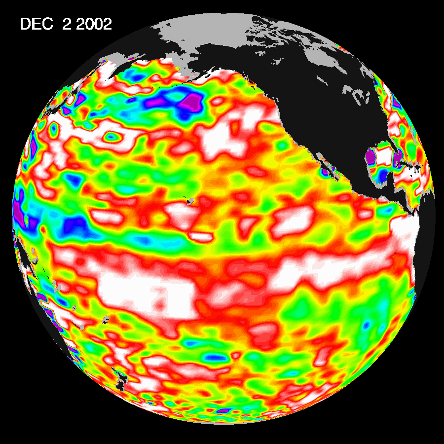
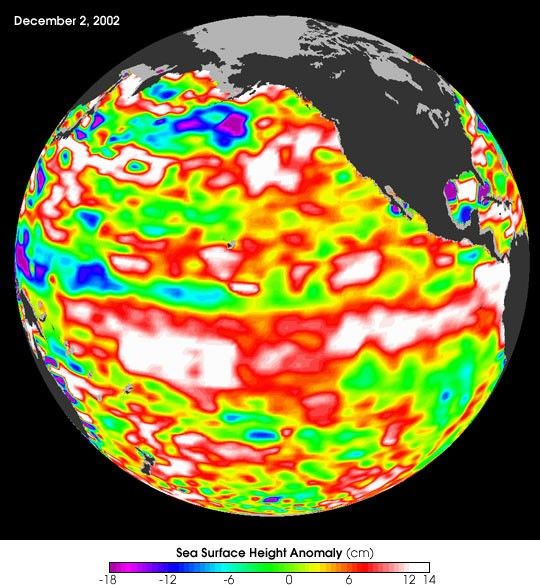
The latest image from NASA’s Jason oceanography satellite, taken duringa 10-day collection cycle ending December 2, 2002, shows the Pacificdominated by two significant areas of higher-than-normal sea level(warmer ocean temperatures). In the central equatorial Pacific, thelarge area of higher than normal sea surface heights (warmer than normalsea surface temperatures) associated with growing El Niño conditions hasrecently migrated eastward toward the coast of South America. Meanwhile,the influence of the 20- to 30-year larger than El Niño/La Niña patterncalled the Pacific Decadal Oscillation continues to create warm,higher-than-normal sea-surface heights in the north Pacific that areconnected in a warm horseshoe pattern with the western and southernPacific. Sea-surface heights are a measure of how much heat is stored inthe ocean below. This heat influences both present weather and futureplanetary climate events.
The image shows red areas in the north Pacific and at the equator thatare about 10 centimeters (4 inches) above normal; white areas indicatesea surface heights between 14 and 32 centimeters (6 to 13 inches) abovenormal. These regions contrast with the western tropical Pacific, wherelower-than-normal sea levels (blue areas) have developed that arebetween 5 and 13 centimeters (2 and 5 inches) below normal, while purpleareas range from 14 to 18 centimeters (6 to 7 inches) below normal.Along the equator, the red sea surface heights equate to sea surfacetemperature departures greater than one degree Celsius (two degreesFahrenheit) and the white sea surface heights are sea surfacetemperatures 1.5 to 2.5 degrees Celsius (three to five degreesFahrenheit) above normal.
For more information about the current El Niño, read:
NOAA Says El Niño to Influence U.S. Weather and
The Return of El Niño
References & Resources
Image Courtesy Jason Science Team, JPL/Centre National d'Etudes Spatiales