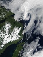
The Petermann Ice Island-A (PII-A) continued drifting southward on July 28, 2011. The Moderate Resolution Imaging Spectroradiometer (MODIS) on NASA’s Aqua satellite captured this natural-color image the same day.
On July 8, the Canadian Ice Service reported that PII-A was losing mass due to calving and melt. Although clouds partly obscure the satellite sensor’s view of the ice island in this image, it does appear to have shed some ice blocks around its fringes, especially off its northeastern corner and western side.
PII-A is about 27 kilometers (17 miles) east of Belle Isle. The ice island and the real island look like they are roughly the same size and even the same general shape.
References & Resources
- Canadian Ice Service (2011, July 8). Petermann Ice Island Updates. Accessed July 29, 2011.
NASA image courtesy Jeff Schmaltz, MODIS Rapid Response, NASA Goddard Space Flight Center. Caption by Michon Scott.