


After grazing Florida and Georgia, Hurricane Matthew plowed into South Carolina southeast of McClellanville as a category 1 storm. Strong winds, falling trees, and storm surge flooding knocked out power in coastal areas of all three states.
From space, the outages were clearly visible. The Visible Infrared Imaging Radiometer Suite (VIIRS) on the Suomi NPP satellite captured these three nighttime images of the Atlantic coast. The image on the left was acquired at 3:14 a.m. Eastern Daylight Time (07:14 Universal Time) on October 6, 2016; the middle image shows the same area at 3:14 a.m. on October 7; the image on the right was acquired at 2:14 a.m. on October 8.
The VIIRS images were captured by the sensor’s day-night band, which detects light in a range of wavelengths from green to near-infrared and uses filtering techniques to observe signals such as gas flares, city lights, and reflected moonlight. Infrared observations collected by the GOES East satellite were layered on the VIIRS data to make the clouds associated with Matthew more visible. Notice how many cities and towns on the eastern coast of Florida lost power on October 7. By the next day, power had been restored in some areas.
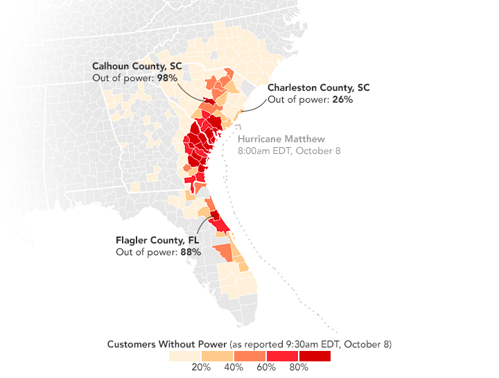
As of 1:00 p.m. Eastern Daylight Time on October 8, 2016, Florida Power & Light Company reported that 400,000 customers were without power. In Georgia, 272,000 Georgia Power customers were in the dark. South Carolina Gas & Electric had 268,000 customers without power; Duke Energy had an additional 70,000 customers in the dark in South Carolina and 84,000 in North Carolina. The map above is based on data from the power companies. In particular, Flagler County, Florida, and Calhoun County, South Carolina suffered many outages.
“Many hurricane-related deaths occur with power outages. Don’t run generators or use open flames indoors. Avoid downed wires,” cautioned Rick Knabb, the director of the National Hurricane Center in a tweet.
More NASA Coverage of Matthew
- NASA Earth Observatory (2016, October) Matthew.
- NASA Goddard Space Flight Center (2016, October 8, ) Matthew (Atlantic Ocean) Accessed October 8, 2016.
- NASA Precipitation Measurement Mission (2016, October 7) Video: A Look Inside Matthew. Accessed October 8, 2016.
- Hazards Data Distribution System Explorer (2016, October 8) Hurricane Matthew. Accessed October 8, 2016.
References & Resources
- Duke Energy (2016, October 8) Current Outages. Accessed October 8, 2016.
- Florida Power & Light Company (2016, October 8) Outages. Accessed October 8, 2016.
- Georgia Power (2016, October 8) Outage Information. Accessed October 8, 2016.
- Mashable (2016, October 7) Hurricane Matthew: How to follow the storm like a true weather geek. Accessed October 8, 2016.
- NASA Earth Observatory (2012, December 5) Out of the Blue and Into the Black.
- National Hurricane Center (2016, October 8) Hurricane Matthew. Accessed October 8, 2016.
- South Carolina Electric & Gas (2016, October 8) Outage Map. Accessed October 8, 2016.
- Weather Underground (2016, October 7) Matthew, Atlantic’s Deadliest Hurricane in 11 Years, Heads for Georgia, S. Carolina. Accessed October 7, 2016.
NASA Earth Observatory maps by Joshua Stevens, using VIIRS day-night band data from the Suomi National Polar-orbiting Partnership , data from the NASA-NOAA GOES project, and Unisys Weather . Suomi NPP is the result of a partnership between NASA, the National Oceanic and Atmospheric Administration, and the Department of Defense. Caption by Adam Voiland.


