For much of May 2023, wildland fires raged in western Canada. In the last few days of the month, blazes flared up thousands of miles to the east as well, in the Atlantic province of Nova Scotia. The fires, unusually large for Nova Scotia, forced the evacuation of thousands of people.
Smoke billowed from a fire near the town of Shelburne on May 29, when an astronaut on the International Space Station took this photograph. By the morning of May 31, after four days of burning, the fire had scorched 17,000 hectares (66 square miles) near the southern tip of Nova Scotia. It became the largest forest fire in the province’s history, according to CBC Nova Scotia, exceeding the area burned (13,000 hectares) by a fire in Guysborough County over six days in June 1976.
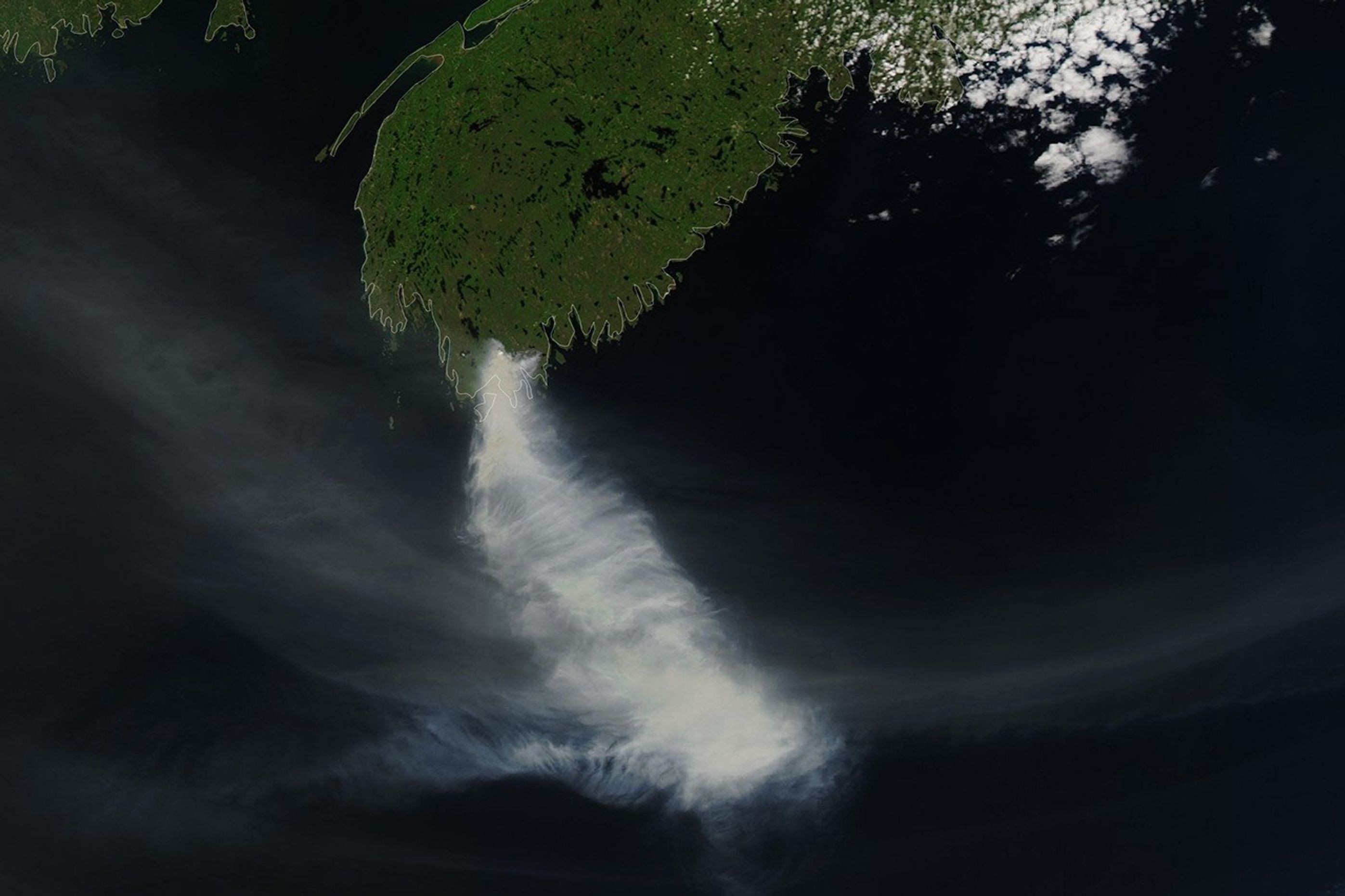
On May 29, the Moderate Resolution Imaging Spectroradiometer (MODIS) on NASA’s Aqua satellite captured a wider view of the blaze in Shelburne County (below). The fire grew rapidly from 6,000 hectares on that day to 17,000 hectares two days later, due to dry and windy conditions. More than a thousand people were evacuated from the area.

Around the same time, a smaller fire burned near Halifax, the province’s capital. As of May 31, this blaze had consumed 837 hectares (3 square miles) near the heavily populated region, spurring the evacuation of 16,000 people. About 200 homes and other structures were damaged, according to Nova Scotia’s government.
Fires have burned in Canada for weeks, as the western part of the country experienced a record-breaking streak of hot weather in mid-May. Several regions in Canada also had an abnormally dry spring; Nova Scotia received about half of the usual amount of rainfall in April. Authorities classified both the Halifax and Shelburne County fires as uncontrolled on May 31 and expected the fires to grow as dry and windy conditions continued.
NOAA’s GOES East satellite observed smoke from the fires sweeping over the northeastern United States on May 30. Air quality alerts were issued on that day in Rhode Island, Massachusetts, and parts of New Jersey and Pennsylvania.
Fire activity in Canada has been unusually destructive in 2023. Two million hectares (800 square miles) had burned by the end of May, which is 13 times the 10-year average for that time of year.
References & Resources
- Agriculture and Agri-Food Canada (2023, April 30) Canadian Drought Monitor. Accessed May 31, 2023.
- BBC (2023, May 30) Thousands evacuate as Nova Scotia fights wildfires. Accessed May 31, 2023.
- CBC Nova Scotia (2023, May 31) Province to give update on Shelburne County blaze, now the largest wildfire in N.S. history. Accessed May 31, 2023.
- CBC Nova Scotia (2023, May 30) N.S. implements provincewide ban on travel, activity in woods due to wildfires. Accessed May 31, 2023.
- CNN (2023, May 30) Canadian wildfire smoke impacting air quality in US Northeast for second day. Accessed May 31, 2023.
- NASA Earth Observatory (2023, May 18) Summer Temperatures Arrive Early.
- NASA Earth Observatory (2023, May 26) A Smoky May for North America.
- NASA Earth Observatory (2023, May 9) Fires Scorch Western Canada.
- Natural Resources Canada National Wildland Fire Situation Report, Current Graphs. Accessed May 31, 2023.
- Nova Scotia Government (2023, May 30) Update on Wildfires in Halifax Regional Municipality and Shelburne, Yarmouth Counties. Accessed May 31, 2023.
- Nova Scotia Government (2023, May 31) Update on Wildfires. Accessed May 31, 2023.
- Nova Scotia Government 2022 Wildfire Statistics. Accessed May 31, 2023.
- Shelburne County East Emergency Management, via Facebook (2023, May 31) Wildfire Update. Accessed May 31, 2023.
NASA Earth Observatory image by Wanmei Liang, using MODIS data from NASA EOSDIS LANCE and GIBS/Worldview . Astronaut photograph ISS069-E-15007 was acquired on May 29, 2023, with a Nikon D4 digital camera using an 400 millimeter lens and is provided by the ISS Crew Earth Observations Facility and the Earth Science and Remote Sensing Unit, Johnson Space Center. The image was taken by a member of the Expedition 69 crew . The image has been cropped and enhanced to improve contrast, and lens artifacts have been removed. The International Space Station Program supports the laboratory as part of the ISS National Lab to help astronauts take pictures of Earth that will be of the greatest value to scientists and the public, and to make those images freely available on the Internet. Additional images taken by astronauts and cosmonauts can be viewed at the NASA/JSC Gateway to Astronaut Photography of Earth . Story by Emily Cassidy .