


May 13-29, 2018
Rain Soaks the Empty Quarter
Today’s story is the answer to the
.
Spanning the southern third of the Arabian Peninsula, the Rub’ al-Khali is the world’s largest contiguous sand desert. It is also one of the driest places on Earth; however, that status temporarily changed after Tropical Cyclone Mekunu passed over the region in May 2018.
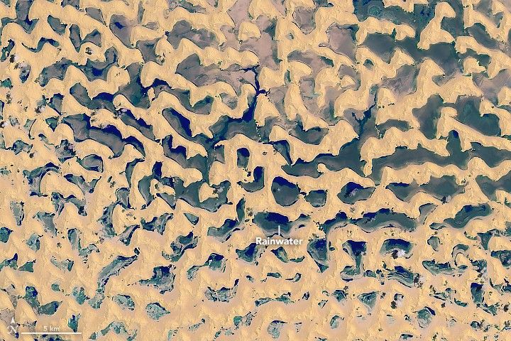
The Operational Land Imager (OLI) on Landsat 8 acquired these false-color images of the eastern part of the desert in Saudi Arabia, near the border of Oman. False-color (bands 7-5-3) makes it easier to distinguish different rock and soil types and to detect the presence of moisture. (See this image to see the desert in natural color as photographed in May 2011 by astronauts on the International Space Station.)
The first image was acquired on May 29, three days after the center of Mekunu had moved ashore over Oman. Salalah, a large port city in Oman about 300 kilometers (190 miles) south of this image, reportedly received 278 millimeters (11 inches) of rain over 24 hours between May 25–26—more than twice the average amount the city sees in a year.
Mekunu dissipated as it tracked northwest over land, but still delivered plenty of water to the desert. Notice where water collected in the lowlands between sand dunes. For comparison, the second image was acquired on May 13 and represents the typically dry appearance of the interdune sand flats. Turn on the image comparison tool to see the difference.
It is rare for rainwater to form lakes in this part of the desert, which is known as the “Empty Quarter.” Sand composing dunes of all shapes and sizes, interspersed with salt flats, make up the majority of the landscape. According to news reports, this desert received on average 3 centimeters (1.2 inches) of rain per year. It has been about 20 years since rainwater last filled the flats.
The rainwater is expected to give rise to summertime vegetation. Al Arabiya reported that such vegetation will be a boon for camel owners, who expect to feed the animals on the plants for the next two years.
References & Resources
- Al Arabiya (2018, May 29) Saudi Arabia’s Empty Quarter now ‘full’ with lakes after Cyclone Mekunu. Accessed June 15, 2018.
- Almazroui, M. et al. (2012) Recent climate change in the Arabian Peninsula: annual rainfall and temperature analysis of Saudi Arabia for 1978–2009. International Journal of Climatology, (32)6, 953–966.
- Gizmodo (2015, May 3) The Empty Quarter Is The Largest Sand Sea On The Planet. Accessed June 15, 2018.
- Hasanean, H. and Almazroui, M. (2015) Rainfall: Features and Variations over Saudi Arabia, A Review. Climate, (3)3, 578–626.
- NASA Earth Observatory (2018, May 19) Cyclone Duo Hits the Middle East.
- NASA Earth Observatory (2011, May 30) Ar Rub’ al Khali Sand Sea, Arabian Peninsula.
- Sciencing (2017, April 25) The Driest Places on Earth With the Least Rain. Accessed June 15, 2018.
- The Weather Channel (2018, May 27) Tropical Cyclone Mekunu Made an Historic Category 3 Landfall Near Salalah, Oman With Life-Threatening Flooding, Destructive Winds, Storm Surge. Accessed June 15, 2018.
NASA Earth Observatory images by Lauren Dauphin, using Landsat data from the U.S. Geological Survey . Story by Kathryn Hansen.


