January 18, 2012
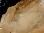
Dust plumes blew across the western Sahara Desert on January 18, 2012. The Moderate Resolution Imaging Spectroradiometer (MODIS) on NASA’s Aqua satellite took this picture the same day.
Arising from discrete source points, the dust blows from northeast to southwest. Sand seas straddle the Mauritania-Algeria border, and many of the dust plumes arise in that region. In the southwest, over Mauritania, the plumes coalesce into a large mass of dust spanning more than 200 kilometers. Thinner plumes blow westward over Western Sahara toward the Atlantic coast.
References & Resources
NASA images courtesy Jeff Schmaltz, LANCE/EOSDIS MODIS Rapid Response Team at NASA GSFC. Caption by Michon Scott.