Suggested Searches

1 min read

Smoke over Pacific Northwest

Instruments:
2003-09-02 00:00:00
September 2, 2003

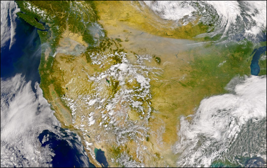
Smoke pouring from numerous fires in thenorthwestern United States and Canadaobscured the ground over much of the Pacific Northwest and Great Plains region. The smoke (gray pixels) was so thick it filled a number of the valleys in the mountainous regions of the northwest. Some of the smoke appears to have been drawn eastward along the southern edgeof the low-pressure cell visible overManitoba (in the high-resolution version of this scene).

This true-color image was acquired by the Sea-viewing Wide Field-of-view Sensor (SeaWiFS) on September 2, 2003.

References & Resources

Image courtesy the SeaWiFS Project, NASA/Goddard Space Flight Center, and ORBIMAGE

You may also be interested in:

Stay up-to-date with the latest content from NASA as we explore the universe and discover more about our home planet.

Ontario Wildfire Smoke Moves East
3 min read

Canadian wildfires sent plumes of smoke streaming over Ontario, Quebec, and parts of the U.S. Midwest and Northeast.

Article
A Week of Smoky Skies Across North America
3 min read

Brown carbon, emitted by wildland fires and tracked over the span of a week in July 2026, worsened air quality…

Article
Cascade Volcanoes Shrouded in Smoke
3 min read

From the International Space Station, astronauts photographed Mount Hood and Mount Rainier as wildfire smoke spread across the Pacific Northwest…

Article