


Rainfall was abundant across the Eastern United States in 2018, with many cities measuring their wettest year on record. Not all of that water immediately ends up in streams, lakes, and the ocean; some seeps deep into the soil, where it can influence groundwater levels for months to come.
This map shows how shallow groundwater has responded to the unusually wet conditions this year. The colors depict the wetness percentile; that is, how the amount of shallow groundwater on December 17, 2018, ranks among all the Decembers from 1948 to 2012. Blue areas have more abundant groundwater than usual for the time of year, and orange and red areas have less.
Several major cities received exceptional rainfall in 2018. Washington, D.C., surpassed the previous annual rainfall record of 61.33 inches set in 1889, accumulating 64.22 inches by the date of this map. Baltimore, Maryland, soared over its previous record of 62.66 inches set in 2003 with 68.77 inches. Wilmington, North Carolina, has received a whopping 99.98 inches so far this year.
The extent to which such rainfall affects the groundwater level varies by location and depends on a range of factors such as soil type, aquifer depth, and vegetation. Time is also a factor, as rainfall accumulations from months ago can influence current groundwater levels. Still, the blue areas shown in this map are a clear reflection of the record amount of rain.
The map is based on multiple types of meteorological data (precipitation, temperature, etc.) integrated within an advanced computer model developed by scientists at NASA’s Goddard Space Flight Center. Notably, the model incorporated observations of the total amount of water stored on and in the land from NASA’s Gravity Recovery and Climate Experiment (GRACE) satellites until June 2017. Data from the new GRACE-FO satellites will be used beginning early next year. Until then, the maps rely heavily on the meteorological data.
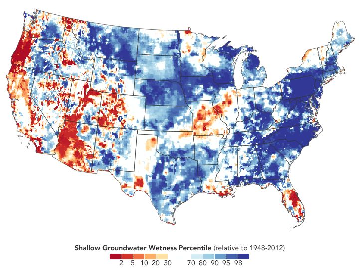
The soggy conditions appear to be limited to the U.S. East and Midwest. Areas in the West and Southwest continue to face an ongoing drought.
References & Resources
- Climate Central (2018, December 12) 2018âs Precipitation Records On One Map. Accessed December 19, 2018.
- NPR (2018, December 15) 2018 Is Now The Wettest Year On Record For Washington And Other Cities. Accessed December 19, 2018.
- University of Nebraska-Lincoln: The National Drought Mitigation Center (2018, December 17) Groundwater and Soil Moisture Conditions from GRACE Data Assimilation. Accessed December 19, 2018.
- The Washington Post (2018, December 14) Soaking rain this weekend set to propel Washington to its wettest year on record. Accessed December 19, 2018.
NASA Earth Observatory images by Joshua Stevens, using GRACE data from The National Drought Mitigation Center at the University of Nebraska-Lincoln, and rainfall data from The Iowa Environmental Mesonet (IEM). Story by Kathryn Hansen.


