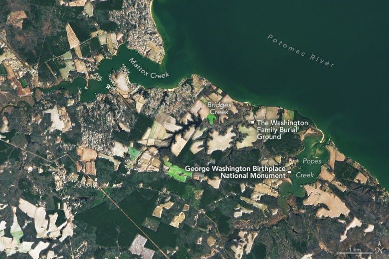
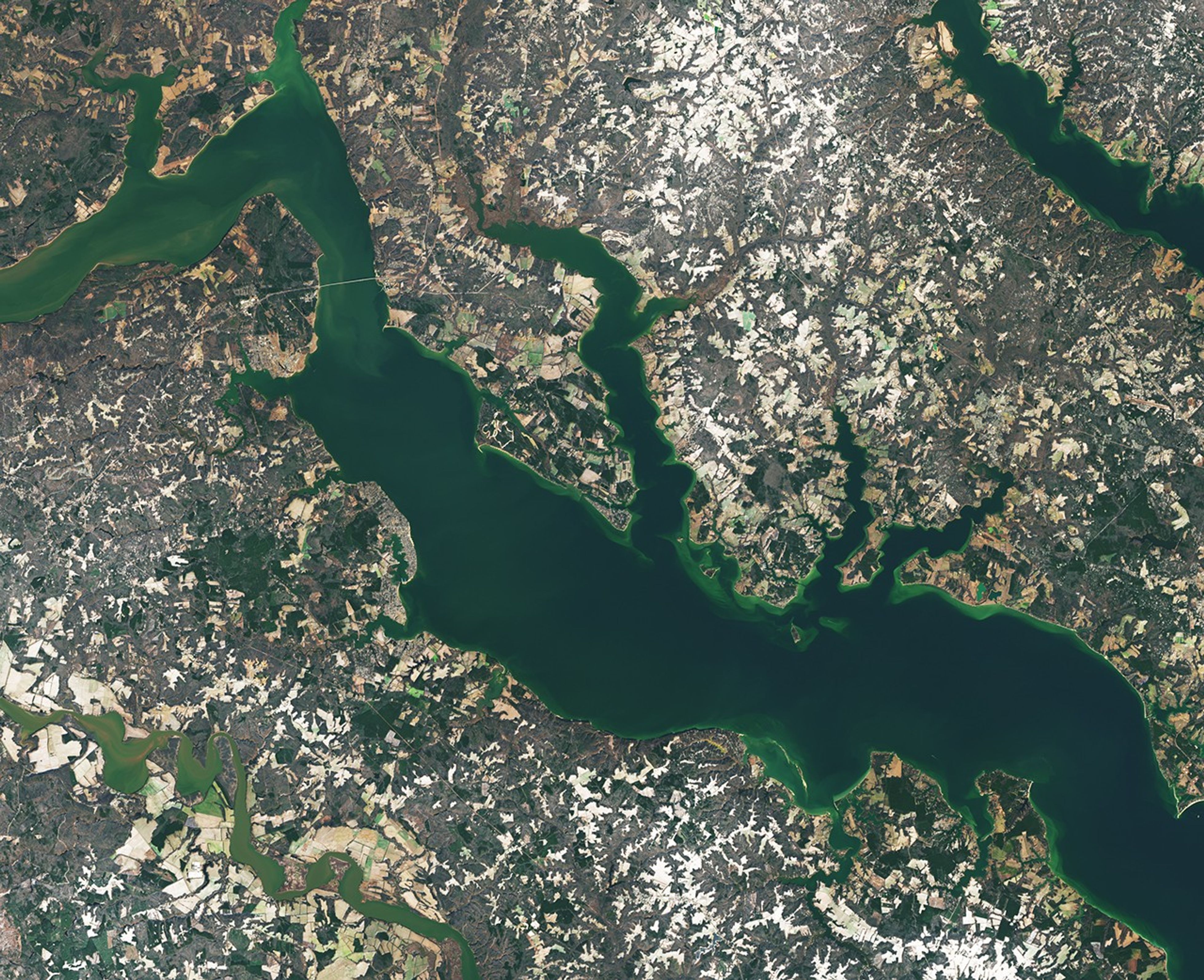
George Washington spent much of his life at Mount Vernon, his beloved estate in Virginia overlooking the Potomac River, but that is not where life began for America’s first president. He was born on February 22, 1732, about 80 miles (130 kilometers) to the south in Westmoreland County, in a brick house along Popes Creek.
Though mid-February is typically chilly in Westmoreland County, signs of spring had started to emerge across the swampy, rolling lands held by the family when Washington was born. The birth, according to a brief note in the Washington family Bible, occurred around 10 a.m. on a day when the jasmine and jonquils had begun to bloom.
The OLI (Operational Land Imager) on Landsat 8 captured this scene of the lands west of Popes Creek—now the site of the George Washington Birthplace National Monument—on January 19, 2026. While the home where Washington was born sat just a few hundred feet from Popes Creek, lands owned by the Washington family extended northwest toward Mattox Creek. The family’s burial ground lies in the center of the image along Bridges Creek, where dozens of relatives are interred, including Washington’s parents, grandparents, and great-grandparents on his father’s side.
Washington’s time at Popes Creek was brief, and the historical record detailing his time there is limited. What is known, however, is that before his parents moved the family to Mount Vernon, he spent his first three-and-a-half years living on farmland in an area first settled by his great-great-grandfather in 1657. Archaeological evidence indicates that Native Americans used the land to hunt game and the area's streams and rivers to harvest oysters and fish for shad and herring prior to the arrival of Europeans. George Washington's father used the land to manage a plantation and, with a few dozen enslaved people, raised tobacco and tended a kitchen garden with herbs, fruits, and vegetables.
After the family’s move to Mount Vernon, Washington made occasional visits to Popes Creek. Historians think that during one of these, he made an early attempt at land surveying, an activity that would later become his occupation. Below is an image of what is likely one of his first surveying maps, drafted when he was a teenager, depicting the lands around Popes Creek. The map accurately represents the location of several key waterways, including Mattox Creek, Bridges Creek, and Popes Creek. Both Mattox Creek and Popes Creek are tidal tributary streams of the Potomac, meaning their flow is influenced by the ebb and flow of ocean tides.
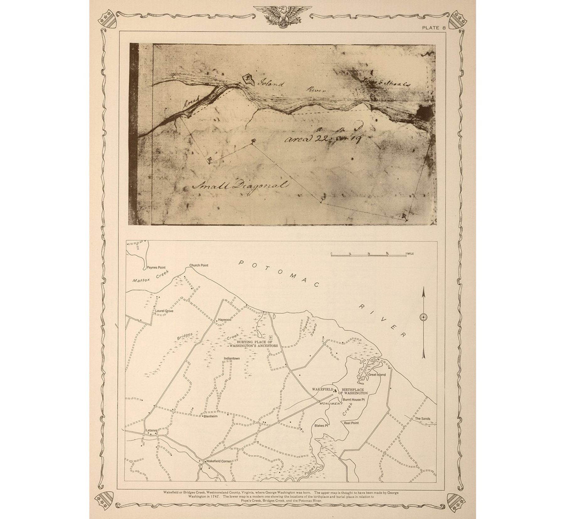
By the age of 17, Washington had been named the official surveyor of nearby Culpeper County. He completed 199 surveys within three years, covering more than 60,000 acres (24,000 hectares), according to the Mount Vernon Ladies' Association. He also conducted surveys on Virginia’s western frontier in Frederick and Hampshire counties. Historians credit the backcountry and mapmaking skills he gained as a land surveyor with playing an important role in his military career during the French and Indian War and ultimately helping launch his rise to general and commander-in-chief during the Revolutionary War and, eventually, to the U.S. presidency.
NASA Earth Observatory image by Michala Garrison, using Landsat data from the U.S. Geological Survey. Map courtesy of the David Rumsey Map Collection, David Rumsey Map Center, Stanford Libraries. Story by Adam Voiland.
References & Resources
- David Rumsey Map Collection (1747) Wakefield or Bridge Creek, Westmoreland County, Virginia. Accessed February 12, 2026.
- Library of Congress Washington as Land Speculator. Accessed February 12, 2026.
- The Mount Vernon Ladies' Association (2025) Surveying. Accessed February 12, 2026.
- National Park Service Historical Handbook Series (1956) George Washington Birthplace National Monument Virginia. Accessed February 12, 2026.
- NASA Earth Observatory (2025, February 17) A Most “Pleasantly Situated” Estate. Accessed February 12, 2026.
- National Archives George Washington's Birthday. Accessed February 12, 2026.
- National Park Service (2026) George Washington Birthplace Monument. Accessed February 12, 2026.
- Santelli, S., via The Mount Vernon Ladies Association Popes Creek. Accessed February 12, 2026.