

Today’s story is the answer to the February 2024 puzzler.
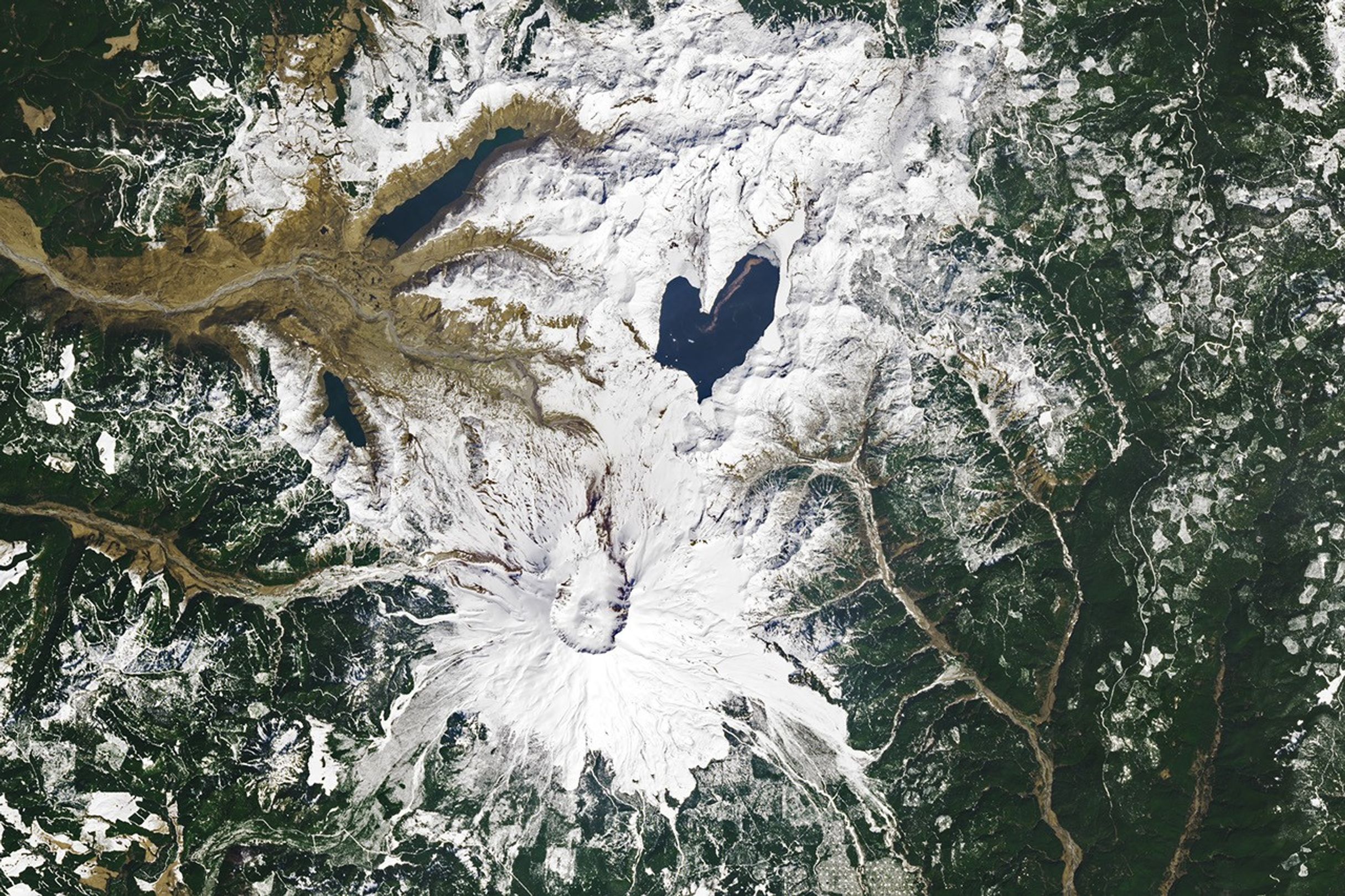
Spirit Lake is resilient. The lake and once-popular tourist site in south-central Washington was nearly obliterated in May 1980 during the events that unfolded around the cataclysmic eruption of Mount St. Helens. The lake survived, and it took on a lovely new shape.
The OLI (Operational Land Imager) on Landsat 8 acquired these images on April 26, 2023. A white blanket of snow contrasts with the dark-blue water, emphasizing the lake’s heart-like shape when viewed from above.
Prior to the eruption, Spirit Lake had a smaller footprint that consisted of west and east arms connected by a narrow span of water—similar in shape to the top-half of a heart. Then, on May 18, 1980, the volcano’s north flank let loose, producing the largest-known landslide in recorded history, followed by a lateral blast and shock wave as the eruption unfolded. The water in Spirit Lake was temporarily displaced but eventually flowed back into the basin.

A “new” lake reformed atop the debris from the landslide. The fully-heart shaped lake was broader and shallower, and the elevation of its surface higher by nearly 60 meters (200 feet). Some of the landslide debris formed a blockage, or natural dam, on the lake’s southwest side. Without an outlet, water levels continued to rise until engineers constructed a drainage tunnel in 1985.
From the 1920s through the 1970s, Spirit Lake drew tourists to its shores. Cabins and lodges lined the lake, and people could swim, boat, and fish in its waters. Today, those lakeside features are buried in avalanche debris below the modern lake.
Fishing and swimming are prohibited, and access is limited to preserve the site as a natural laboratory for studying the landscape’s recovery. For example, scientists think that the trees uprooted by the volcanic blast and still floating in the lake, visible as the brown line in the detailed image above, have become an important part of the lake’s ecosystem.
References & Resources
- Forest Service (2017) The Geologic, Geomorphic, and Hydrologic Context Underlying Options for Long-Term Management of the Spirit Lake Outlet Near Mount St. Helens, Washington. Accessed February 13, 2024.
- Larson, D. (1993) The Recovery of Spirit Lake. American Scientist, 81 (2), 166–177.
- NASA Earth Observatory (2021, November 1) The Floating Logs of Spirit Lake. Accessed February 13, 2024.
- NASA Earth Observatory (2016) World of Change: Devastation and Recovery at Mt. St. Helens. Accessed February 13, 2024.
- U.S. Geological Survey (2019) Field Trip Guide to Mount St. Helens, Washington—Recent and Ancient Volcaniclastic Processes and Deposits. Accessed February 13, 2024.
NASA Earth Observatory images by Wanmei Liang , using Landsat data from the U.S. Geological Survey . Story by Kathryn Hansen.