On April 8, 2024, millions of Americans saw day turn temporarily to night as the Moon passed between the Sun and Earth to create a total solar eclipse.
As people in the 115-mile-wide (185-kilometer-wide) path of totality looked up and saw the Moon conceal the bright orb of the Sun and obscure all but its wispy corona, Earth-observing satellites captured imagery of the Moon’s shadow as it raced eastward over North America.
About 1 million miles from Earth, NASA’s EPIC (Earth Polychromatic Imaging Camera) imager on the DSCOVR (Deep Space Climate Observatory) satellite, captured the above views of Earth between 16:02 and 20:32 Universal Time (12:02 and 4:32 p.m. Eastern Time). DSCVR is a joint NASA, NOAA, and U.S. Air Force satellite built to observe our planet from Lagrange Point 1, a gravitationally stable position between the Sun and Earth.
The Moon’s shadow swept over North America, from the Pacific coast of Mexico, through Texas, and over the Great Lakes before crossing the Atlantic coast of Newfoundland, Canada.

Observers on the ground had a rare view of the Sun’s active outer atmosphere, or corona.
called solar prominences could also
extending into the corona.
is super-hot ionized gas which flows along the tangled and twisted structure of the Sun’s magnetic fields.
“This view of the corona will never happen again, ever,” said Michael Kirk, a research scientist in the Heliophysics Division at NASA’s Goddard Space Flight Center during a live broadcast of the eclipse from Dallas, Texas. During the broadcast, Kirk noted that the spiky and asymmetrical nature of the corona was a sign that the Sun’s magnetic field was active and approaching solar maximum.
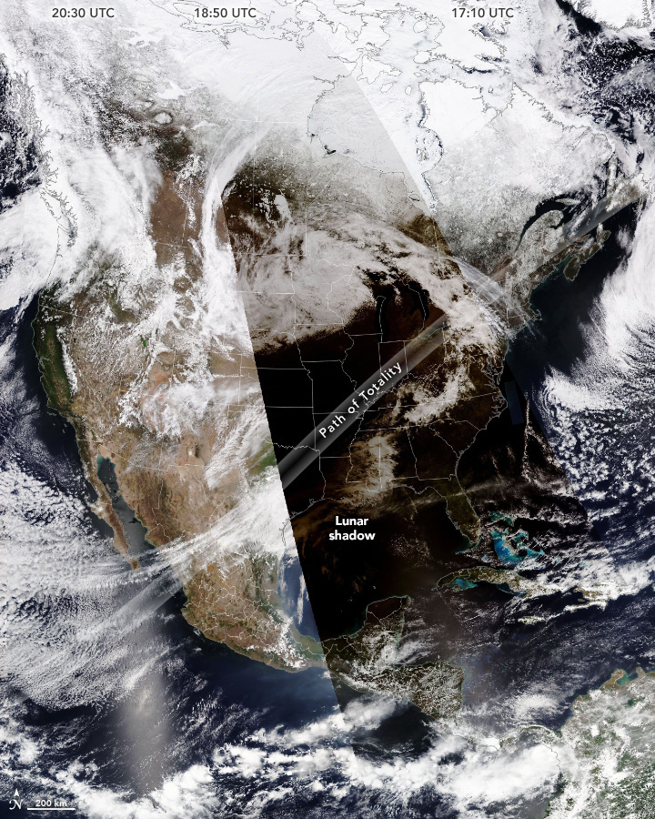
As the Moon’s shadow moved east across North America, the NOAA-20 satellite orbited the Earth from pole to pole and captured images of Earth from east to west. The image above is a mosaic comprised of swaths of images collected by the satellite at three different times on April 8. The right third of the image shows the eastern United States at about 1:10 p.m. Eastern Time (17:10 Universal Time), before the eclipse had begun. The middle part was captured at about 1:50 p.m. Central Time (18:50 Universal Time), when the eclipse was in progress in the center of the country. Even outside of the path of totality, skies were much darker throughout the U.S. The left third of the image was collected at about 1:30 p.m. Pacific Time (20:30 Universal Time), after the Moon’s shadow had moved out over the Atlantic Ocean.
The path of totality included portions of Texas, Oklahoma, Arkansas, Missouri, Illinois, Kentucky, Indiana, Ohio, Pennsylvania, New York, Vermont, New Hampshire, and Maine. The next total solar eclipse to travel across the lower 48 states from coast to coast will be in 2045.
References & Resources
- NASA 2024 Total Solar Eclipse. Accessed April 9, 2024.
- NASA (2024, January 30) How the 2024 Total Solar Eclipse Is Different than the 2017 Eclipse. Accessed April 9, 2024.
- NASA Eclipses & Citizen Science. Accessed April 9, 2024.
- NASA Earth Observatory (2024, March 25) The Best Places to View the Total Solar Eclipse. Accessed April 9, 2024.
- NASA Earth Observatory (2016, March 11) An Epic Eclipse. Accessed April 9, 2024.
- NASA Scientific Visualization Studio (2023, March 8) The 2023 and 2024 Solar Eclipses: Map and Data. Accessed April 9, 2024.
- The New York Times (2024, April 8) Highlights From the Total Solar Eclipse’s Dark Path Through the U.S., Mexico and Canada. Accessed April 9, 2024.
NASA Earth Observatory images by Michala Garrison and Wanmei Liang , using data from DSCOVR EPIC and VIIRS data from NASA EOSDIS LANCE , GIBS/Worldview , and the Joint Polar Satellite System (JPSS). Story by Emily Cassidy .