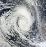
Tropical Cyclone Diane blew over the Indian Ocean, off the Western Australia coast, in late February 2011. The U.S. Navy’s Joint Typhoon Warning Center (JTWC) reported that, as of 11:00 p.m. local time on February 19, Diane was located roughly 355 nautical miles (655 kilometers) west of Learmonth, Western Australia. The storm had maximum sustained winds of 85 knots (155 kilometers per hour) and gusts up to 105 knots (195 kilometers per hour).
The Moderate Resolution Imaging Spectroradiometer (MODIS) on NASA’s Terra satellite captured this natural-color image around 11:00 a.m. local time on February 19, 2011. Skirting the coast of Western Australia, Diane extends hundreds of kilometers to the west.
At 11:00 p.m. local time on February 21, 2011, the JTWC reported that Diane had weakened somewhat and moved farther from land. The storm had maximum sustained winds of 50 knots (95 kilometers per hour), and gusts up to 65 knots (120 kilometers per hour). Located roughly 685 nautical miles (1,270 kilometers) west-southwest of Learmonth, Diane was expected to continue traveling southward over cool seas, dissipating over the next 24 hours.
References & Resources
- Joint Typhoon Warning Center. (2011, February 19 and 21). Tropical Cyclone 16S (Diane) Warning. Accessed February 21, 2011.
NASA Earth Observatory image created by Jesse Allen, using data provided courtesy of the MODIS Rapid Response team. Caption by Michon Scott.