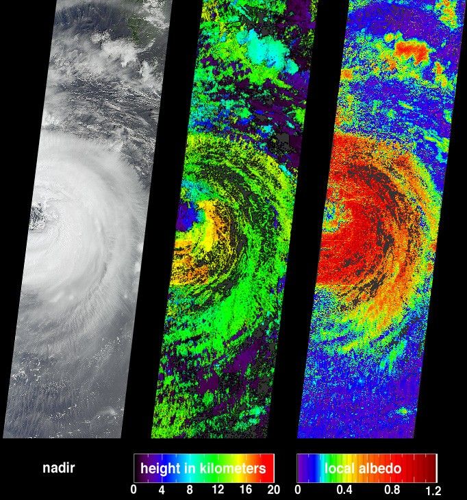
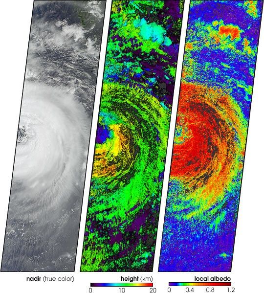
One of the more destructive cyclones to emerge from the Northern Hemisphere 2002summer storm season was Typhoon Sinlaku. Several attributes of this storm eventare portrayed in these data products from the Multi-angle ImagingSpectroRadiometer. The images were acquired on September 5, when the westernportion of the storm was situated over the Okinawan island chain. Over the nextfew days it moved west-northwest, sweeping over Taiwan before making landfallalong China’s Zhejian province on the 7th. The typhoon forced hundreds ofthousands of people from their homes, caused major power outages, and at least26 people were reported dead or missing before the storm weakened as it movedinland.
While the nature and formation of individual storm events is relatively wellunderstood, the influence of clouds on climate is difficult to assess due to thevariable nature of cloud cover at various altitudes. MISR’s data products aredesigned to help understand these influences. Typhoon Sinlaku is shown at leftas a natural-color view observed by MISR’s vertical-viewing (nadir) camera. Thecenter panel shows the cloud-top height field derived using automatedstereoscopic processing of data from multiple MISR cameras. Relative heightvariations, such as the clearing within the storm’s eye, are well represented.Areas where heights could not be retrieved are shown in dark gray.
Clouds have a significant influence on the global radiation balance of theEarth’s atmosphere, and the improvement of climate models requires more accurateinformation on how different types of clouds influence Earth’s energy budget.One measure of this influence is albedo, which is the amount of sunlightreflected back to space divided by amount of incident sunlight. Bright objectshave high albedo. Retrieved local albedo values for Typhoon Sinlaku are shown atright. Generation of this product is dependent on observed cloud radiances as afunction of viewing angle and the cloud height field. Over the short distances(2.2 kilometers) that MISR’s local albedo product is generated, values can begreater than 1.0 due to the contributions from the sides of the clouds. Areaswhere albedo could not be retrieved are shown in dark gray.
The Multi-angle Imaging SpectroRadiometer observes the daylit Earthcontinuously from pole to pole, and views almost the entire globe every 9 days.This image covers an area of about 380 kilometers x 1408 kilometers.
For more images of this storm, visit the Typhoon Sinlaku event page.
References & Resources
Image courtesy NASA/GSFC/LaRC/JPL, MISR Team.