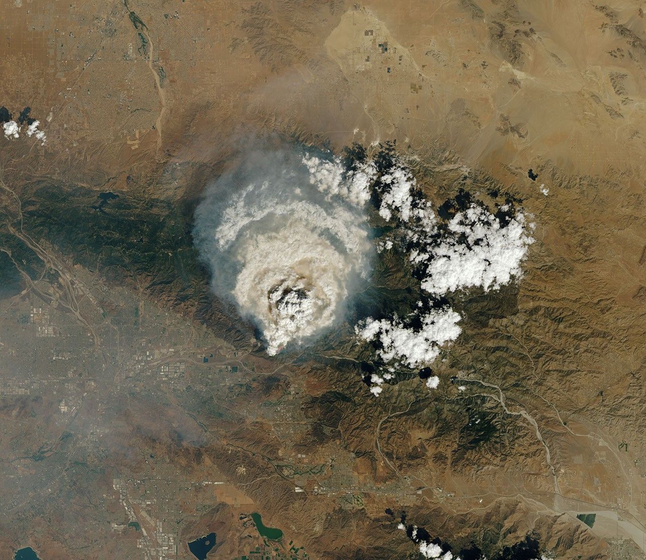

Puffy, white convective clouds popped up in the hills around Los Angeles, Riverside, San Bernardino, and San Diego throughout the afternoon of September 9, 2024. Three of them were different than the others, with their convection fueled, in part, by surface heat associated with intense wildland fires.
Known among meteorologists as pyrocumulus or flammagenitus—or sometimes just “fire clouds”—these tall, billowing features typically have a column of smoke at their base and powerful updrafts that channel large amounts of smoke high into the atmosphere. As the convective plume rises, water vapor condenses around small particles to form cloud droplets and eventually visible clouds at the top of the smoke plume.
That’s what was beginning to happen when the OLI (Operational Land Imager) on Landsat 8 captured these images of a pyrocumulus rising from the Line fire in Southern California. The image includes observations of shortwave-infrared light (red) to highlight the locations of active fires. A faint line of pink fire retardant is also visible on the hills near Redlands.

Later in the day, the pyrocumulus matured into a full-fledged thunderstorm, or pyrocumulonimbus, that generated rain, strong wind gusts, lightning, and even hail, according to KCAL News. On September 7, the National Weather Service’s San Diego office noted that a similar cloud from the Line fire had generated more than 3,700 strikes. Images from other satellites show smoke spiraling upward and spreading outward over the course of the day. Photographs from observers on the ground offered dramatic views of the towering smoky feature as well.
At least 2,000 people, 15 helicopters, 33 dozers, and 232 engines were battling theLine fire on September 10, according to Cal Fire, amid a record-breaking heat wave. As of that afternoon, the fire had charred more than 26,000 acres (105 square kilometers) and had not burned any structures, although more than 65,600 structures were under threat. Residents of several communities have been ordered to evacuate, including Running Springs, Forrest Falls, Mountain Home Village, Angelus Oaks, and Seven Oaks.
References & Resources
- Cal Fire (2024, September 10) Line Fire. Accessed September 10, 2024.
- CBS News (2024, September 9) Inland Empire hit by bizarre weather after smoke from Line Fire creates its own storm system. Accessed September 10, 2024.
- Lareau, N. via X (2024) Radar reconstruction of the the LineFire pyroCb. Accessed September 10, 2024.
- Los Angeles Times (2024, September 9) Lightning, hail, strong winds, flash flood warnings: SoCal has a serious case of fire weather. Accessed September 10, 2024.
- NASA (2023) NASA ARSET Wildland Fire Trainings. Accessed September 10, 2024.
- NBC News (2024, September 6) Record-breaking heat wave expected to extend stay in the West. Accessed September 10, 2024.
NASA Earth Observatory images by Lauren Dauphin, using Landsat data from the U.S. Geological Survey . Story by Adam Voiland .