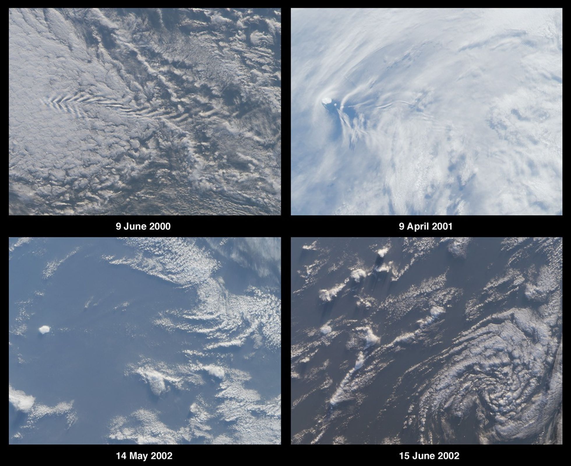

Here’s another chance to play geographical detective! These four images from theMulti-angle Imaging SpectroRadiometer (MISR) cover the same geographic area butwere acquired on four different dates. Each image was acquired by MISR’svertical-viewing (nadir) camera and encompasses an area measuring 257 kilometersx 195 kilometers. North is toward the top.
This mystery concerns a small island located near the western edge of theobserved area. In the top two images, the island presents an obstacle to thewesterly winds, and wake patterns in the cloud layers are visible downstream ofthe island’s location. In the lower left image, the island is visible within arelatively clear area of open ocean. In the lower right image, the island ispartially obscured by cumulus clouds, and a spiral cloud pattern associated withan atmospheric depression is visible in the southeast quadrant.
The Terra satellite, with MISR aboard, flies in a polar orbit and daylightimages such as these are acquired as the spacecraft flies from north to south.Terra’s orbit is “sun-synchronous”, and when the satellite crosses the daylightequator the local time beneath the spacecraft is approximately 10:30 a.m. Thefour images shown here were processed identically, and relative variations inbrightness between the different views have been preserved.
Using any reference materials you like, please answer the following 5questions:
- The images contain multiple clues that can be used to determine whetherthe observed area is situated in the northern or southern hemisphere. Name thehemisphere and describe at least two clues you used to establish your answer.(Clues should not make use of knowledge of the island’s identity.)
- Three of the following four statements about the island’s environment aretrue. Which one is false?
A. Glaciers cover most of the island, and vegetationis limited to lichens and mosses.
B. The island is of volcanic origin andlocated at the intersection of oceanic ridges.
C. A colony of Atlantic puffinsmakes the island its home.
D. The highest peak rises more than 750 meters abovesea level.
- Three of the following four statements about the history of the island aretrue. Which one is false?
A. Sovereignty over the island was transferred fromone country to another sometime between 1918 and 1932.
B. Steep cliffs make theisland difficult to access, and despite many attempts the first landing did nottake place until the 1850’s.
C. In the 19th century, a whaling/sealingexpedition christened the island with the name of a city located in their nativecountry.
D. The earliest documented discovery of the island was by an 18thcentury French explorer, and the island is currently named after thisindividual.
- All five of the following events took place, but only four occurred duringthe second half of the 20th century. Which one did not occur in this timeperiod?
A. The island and adjacent waters were designated a nature reserve.
B. Aweather station was established on the island, providing automated temperatureand pressure data.
C. A nuclear bomb test occurred within 3000 kilometers of theisland.
D. An abandoned boat of unknown origin was discovered on the island. E.The island’s seals were declared to be protected species.
- What is the name of the island and to which country does it belong?
Quiz Rules
E-mail your answers, name (initials are acceptable if you prefer), and yourhometown by Tuesday, July 16, 2002, to suggestions@mail-misr.jpl.nasa.gov.
Answers will be published on the MISR web site (http://www-misr.jpl.nasa.gov) in conjunction with the next weekly image release.The names and home towns of respondents who answer all questions correctly bythe deadline will also be published in the order responses were received. Thefirst 3 people on this list who are not affiliated with NASA, JPL, or MISR andwho did not win a prize in the last quiz will be sent a print of the image.
A new “Where on Earth...?” mystery appears as the MISR “image of the week”approximately once per month. A new image of the week is released everyWednesday at noon Pacific time on the MISR home page. The image also appears on the Atmospheric Sciences Data Centerhome page, http://eosweb.larc.nasa.gov/, though usually with a several-hourdelay.
References & Resources
Image courtesy NASA/GSFC/LaRC/JPL, MISR Team.