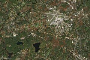
The boundary between Yellowstone National Park and Targhee National Forest is clearly seen in this Landsat 7 image. On the right side of thevertical line running through the center of the image is mature forest located inside the park. In contrast, the forest to the left of the boundary is dominated by numerous clearcuts, shown as light orange/pink amidst the darker,greener forest. The stands of mature trees appear darker than the saplings, shrubs, and grasses growing in clearcuts becausethe tall trees shade the ground beneath them.
The image was taken by Landsat 7 on July 13, 1999. Bands 5 (1.65µm), 4 (.825µm), and 2 (.565µm) were used for red, green, and blue, respectively. Each pixel in the image is 30 meters across. North is towards the top.
For more information, see:
Landsat 7 Fact Sheet
References & Resources
Image by Rich Irish, NASA GSFC
None