Spaceborne Architecture
AOS mission instrumentation and launch details

Spacecraft
AOS-Sky | AOS-Storm (pre-decisional) | HAWCsat | PMM
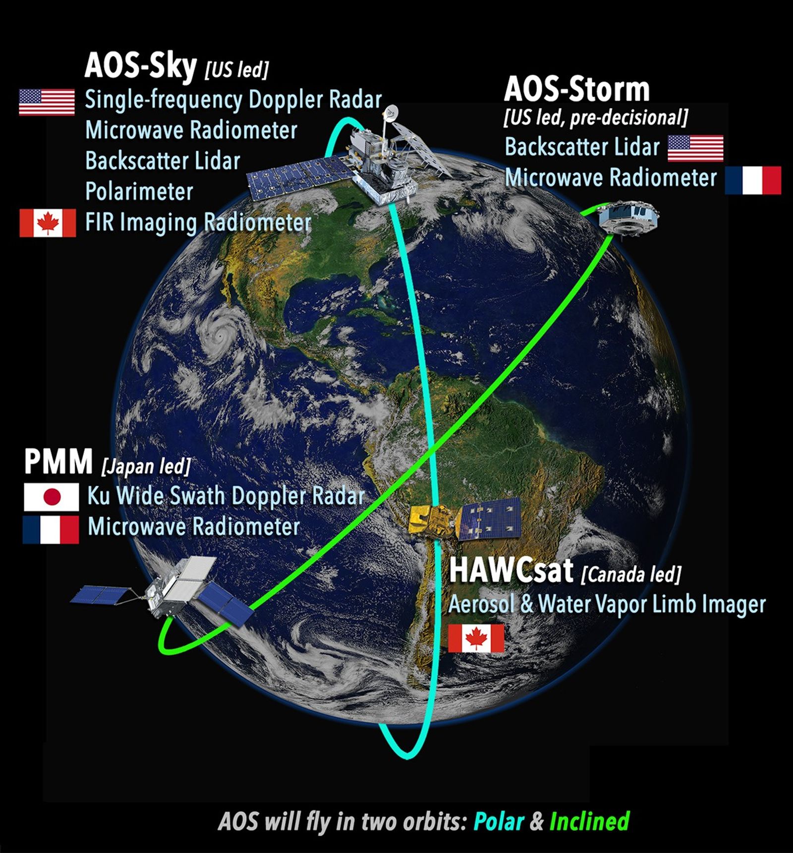
International contributions are marked with flags. Other elements will be provided by NASA/US.
NASA-led Spacecraft
- AOS-Sky - Space Segment Polar
- 97° inclination (i.e., polar) orbit
- Sun synchronous
- 1:30 AM/PM equator crossing
- AOS-Storm – Space Segment GPM
- 55° inclined orbit, similar to GPM (final inclination may be different)
AOS-Sky
| Instrument | Description |
|---|---|
| Single-frequency Doppler Radar | Single-frequency Doppler radar measures clouds and light precipitation, as well as the associated liquid or ice particle motions along the radar line of sight. |
| Microwave Radiometer | Includes a range of channels to measure ice water path, precipitation, atmospheric temperature and humidity. 89-113, 183, 325, 640-700 GHz, 10 km resolution, 750 km swath |
| Backscatter Lidar | Measures attenuated aerosol and cloud backscatter. Backscatter capability at 1064 nm and 532 nm, 30 m vertical resolution, 350 m footprint |
| Multi-angle Polarimeter | Measures polarized radiation at multiple angles to infer cloud and aerosol properties. 9 bands in the 380 to 1570 nm wavelength range, 0.5 km resolution, 300 km swath, multi-angle |
| FIR Imaging Radiometer | Measures ice particle size, cloud top height, cloud longwave emission, water vapor profiles. 8 bands in the 4 - 73 µm wavelength range with 1 km resolution, 100 km swath |
AOS-Storm (pre-decisional)
| Instrument | Description |
|---|---|
| Microwave Radiometer | Includes a range of channels to measure ice water path, precipitation, atmospheric humidity. 89, 183, 325 GHz, 3-10 km resolution, 700 km swath |
| Backscatter Lidar | Measures attenuated aerosol and cloud backscatter. Backscatter capability at 1064 nm and 532 nm, 60 m vertical resolution, 350 m footprint |
High altitude Aerosol Water vapor Clouds satellite (HAWCsat)
| Instrument | Description |
|---|---|
| Aerosol Limb Imager | Measures scattered sunlight from the atmospheric limb (edge of the atmosphere) to resolve information on stratospheric aerosol distribution and particle size. 10 bands in the 610 - 1560 nm wavelength range with 0.25 km vertical resolution, 200 km swath |
| Water Vapor Limb Imager | Water Vapor Limb Imager - measures scattered sunlight from the atmospheric limb (edge of the atmosphere) and measures the concentration of water vapor in the lower stratosphere and upper troposphere. 1362.00 – 1368.32 nm wavelength range with 0.13 km vertical resolution, 63 km swath |
Precipitation Measuring Mission (PMM)
| Instrument | Description |
|---|---|
| Ku Wide-Swath Radar with Doppler | Ku band (13.6 GHz) radar measures precipitation over a 255-km wide swath and the associated liquid or ice particle Doppler motions along the radar line of sight at nadir. Ku-band Doppler, 500 m vertical resolution, 5 km horizontal resolution |
| Microwave Radiometer | Includes a range of channels to measure ice water path, precipitation, atmospheric humidity. 89, 183, 325 GHz, 3-10 km resolution, 700 km swath |
Launch
AOS-Storm will launch mid-2029, followed by AOS-Sky in December 2031. PMM will launch in 2029 and HAWCsat will launch in 2031.