![Request for Information – Potential [Placeholder for Prize]](https://assets.science.nasa.gov/dynamicimage/assets/science/psd/solar/2023/09/s/solarsystem_0.jpg?w=1024)


PROJECT
High Performance GEOS-Chem
SNAPSHOT
An ESTO investment in software optimization helps researchers and citizen scientists model air quality and greenhouse gases with greater resolution, allowing them to better understand how global atmospheric trends impact local areas.

Next-generation software is making it easier for researchers, policy makers, and citizen scientists to model air quality and greenhouse gases using NASA meteorological data.
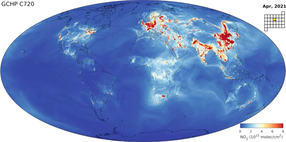
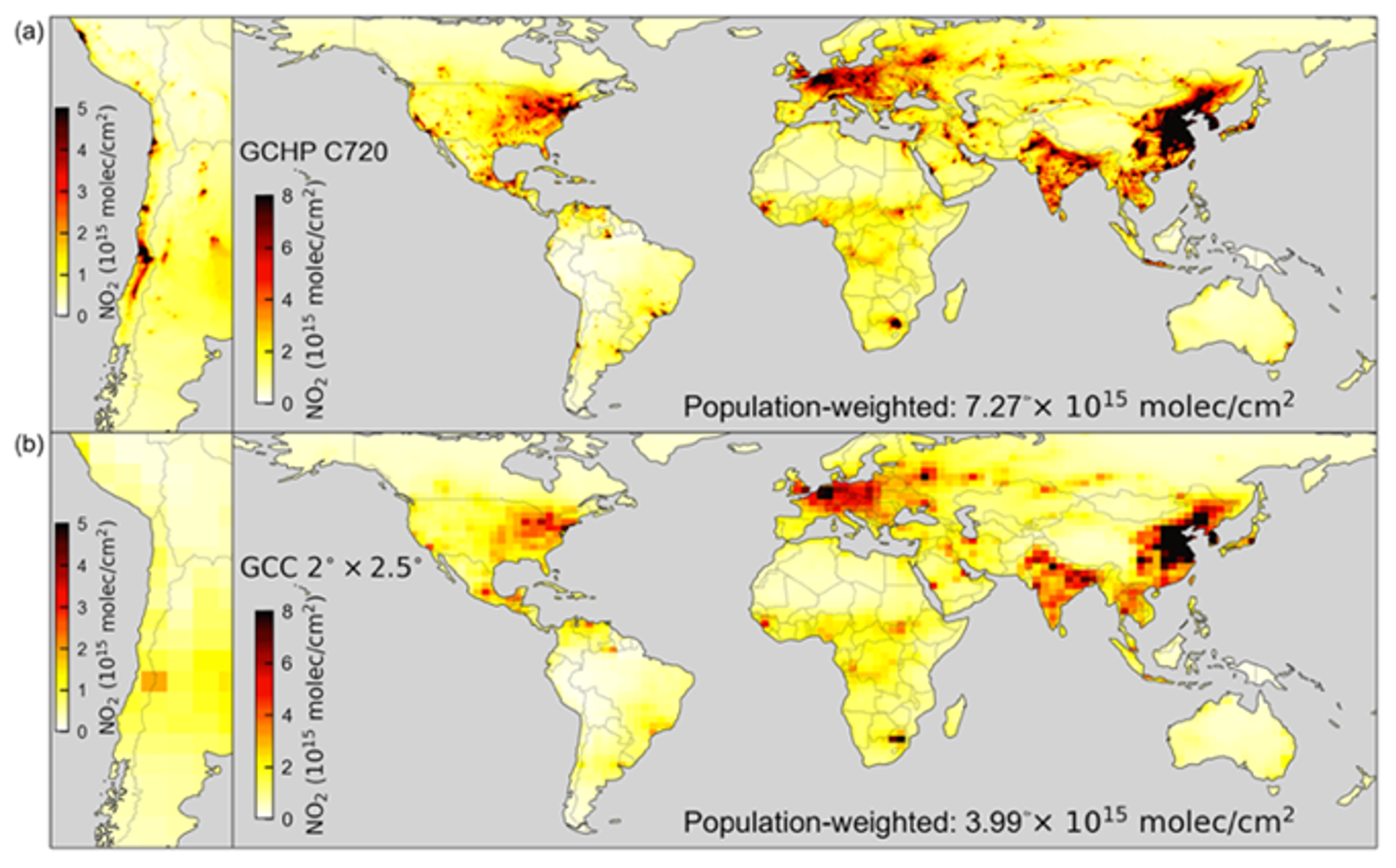
This novel software, “High Performance GEOS-Chem,” uses equations representing the Earth’s atmospheric chemistry and boundary conditions from NASA’s Goddard Earth Observation System (GEOS) to represent global atmospheric chemistry across three dimensions at a horizontal spatial resolution of 12 kilometers by 12 kilometers per pixel—an area about one-fifth the size of New York City.
For comparison, the original GEOS-Chem model that was developed in 2001 only produced global simulations at a spatial resolution of about 200 by 250 square kilometers – an area about twice as large as the entire state of New Jersey.
With this improved resolution, researchers interested in air quality and atmospheric chemistry in specific communities can use models, simulations, and visualizations built with NASA data to better understand how global atmospheric trends impact local areas.
GEOS-Chem is an open-source model freely accessible here. More information about High Performance Geos-Chem – including manuals and tutorials – can be found here.
“This new generation of High Performance GEOS-Chem offers major advancements for ease of use, computational performance, versatility, resolution, and accuracy,” said Randall Martin, a professor at Washington University’s McKelvey School of Engineering and Primary Investigator for the High Performance GEOS-Chem project.
In a recent technical demonstration of their improved GEOS-Chem software, Martin and his team showed two images mapping tropospheric nitrogen dioxide – a pollutant typically produced by burning fossil fuels.
The image produced with High Performance GEOS-Chem featured 200 million more grid cells than the image produced with the original GEOS-Chem software. In other words, High Performance GEOS-Chem creates images more resolute by a factor of about 200.
“We’re really excited. Many features can be examined that aren’t resolved at all at the coarser resolution,” said Martin.
For researchers interested in global air quality and atmospheric composition with local resolution, this new generation of the High Performance GEOS-Chem marks the beginning of a new era for creating descriptive models.
Martin and his team added a number of technological innovations to High Performance GEOS-Chem. In particular, they incorporated a cubed-sphere computation grid into their GEOS-Chem software, reducing noise at the poles and allowing for higher resolution.
High Performance GEOS-Chem also includes a cloud computing capability. This spreads the resource-intensive computation work of generating detailed atmospheric models across dispersed computing nodes, such as Amazon Web Services.
Martin and his team pride themselves on ensuring GEOS-Chem remains an open and accessible tool for anyone interested in simulating atmospheric composition. Their website includes a full suite of tutorial videos, manuals, and guides for using GEOS-Chem effectively.
“NASA enabled us to develop this new generation of GEOS-Chem that has both the additional technical performance and offers the ease of use that this large community requires,” said Martin.
Future iterations of GEOS-Chem could feature further improvements. Developing a better user interface and increasing the modularity of GEOS-Chem are just a few objectives Martin and his team have in mind.
NASA’s Advanced Information Systems Technology (AIST), a part of NASA’s Earth Science Technology Office (ESTO), funded this program.
PROJECT LEAD
Randall Martin, Washington University in St. Louis
SPONSORING ORGANIZATION
Earth Science Division’s Advanced Information Systems Technology (AIST) Program