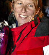
If someone had asked professional yachtswoman and meteorologist Adrienne Cahalan to name her top weather worries before she set out in February 2004 to attempt to break the record for the fastest round-the-world sailing trip, she might have hauled out a list of concerns as long as the list of supplies that a 13-person crew would need on a multi-week journey.
She might have said she was worried about getting stalled in the “horse latitudes” around 30 degrees, where surface winds can disappear for days at a time. She might have mentioned the threat that a fierce gale would hammer their 125-foot catamaran—Cheyenne—into an iceberg in the Southern Ocean off Antarctica. She might have listed the “doldrums” at the equator, where sailors must chase weak and fickle surface winds while navigating a maze of daily thunderstorms fueled by the intensity of the Sun’s most direct rays.
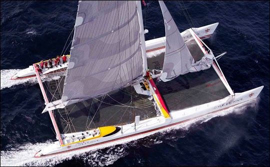
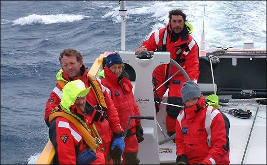
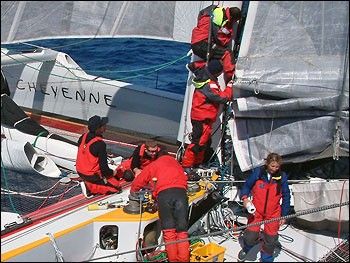
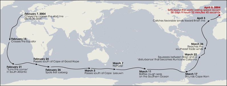
Cahalan would have been thinking of these things because as the crew’s navigator, it was her job to worry about the weather. As they crisscrossed the planet, she would combine weather briefings that arrived every few hours via satellite with real-time, local conditions to route Cheyenne as quickly and safely as possible from the race start line in the English Channel, through each of the world’s oceans, and back to the start line.
Among the weather phenomena Cahalan would not have worried about was an Atlantic Ocean hurricane. After all, who worries about hurricanes in February and March? Little did Cahalan know that in addition to their record-breaking pace, she and the crew of Cheyenne would end up being both helped and hindered along their journey by some record-breaking weather—a storm that looked suspiciously like a hurricane where there was no known record of a hurricane before.
Where the Hurricanes Aren’t
In the Atlantic Ocean north of the equator, hurricane season officially begins in June and is over by the end of November. In the Atlantic Ocean south of the equator, there is no hurricane season because, as any meteorologist will tell you, there are no known records of hurricanes.
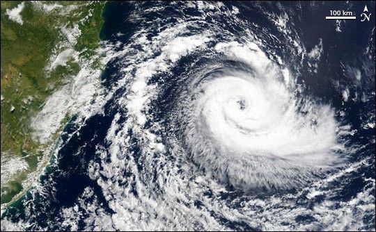
“Hurricanes require a perfect blend of conditions,” explains research meteorologist Marshall Shepherd, of NASA’s Goddard Space Flight Center. Waters must be warm, wind shear must be low, and a disturbance, such as thunderstorms, must jump-start storm formation. “The shear component is particularly detrimental,” says Shepherd. “If the wind increases too quickly with altitude or changes direction, the hurricane is torn apart before it can organize.” With its cooler waters, frequent wind shear, and lack of seedling thunderstorms, the South Atlantic just isn’t a place where scientists or sailors keep watch for hurricanes.
When Cahalan and her crewmates set out on Cheyenne in February 2004, they would never have guessed that their round-the-world sailing record would coincide with some record-breaking weather—the first verifiable account of what appeared to be a hurricane in the South Atlantic Ocean.
A New Career
Growing up in Sydney, on the east coast of Australia, sailing has been a part of Adrienne Cahalan’s life since she was teenager. Even after sailing for over 15 years professionally, it wasn’t until the age of 38 that she returned to school in the United Kingdom for a master’s degree in meteorology. Although trained as a lawyer, her meteorology degree and her racing experience ensured that she would be able to stay at the top of her field as a navigator for international yacht races.
In the old days, the navigator’s responsibility was simply to know where a boat was on the ocean and where it was headed. “Nowadays,” says Cahalan, “GPS provides that information for us, so my main focus is to develop a strategy to handle the weather at any given time, to win races by taking the information we receive via satellite and making the adjustments to our course based on the real-time weather. I work with the crew to decide what sails to use for the weather conditions. At the same time I’m also responsible for the maintenance of electronic equipment—computers, cameras, radars, wireless networks—which can be very sensitive to the marine environment.”
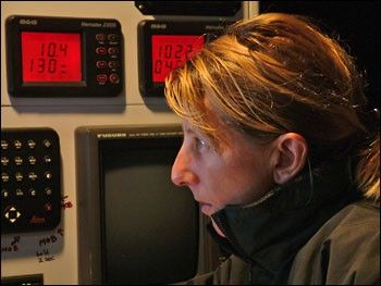
In late 2003 and early 2004, Cahalan was part of a crew who was making preparations for a round-the-world-record attempt when the funding fell through. “I was extremely disappointed,” she says. “So when I got a call in Sydney in February 2004 asking if I could be in England in two days to replace Steve Fossett’s regular navigator on Cheyenne for his attempt at breaking the record, I said ‘Sure, of course.’” American Steve Fossett is an adventurer who has used his own fortune to finance efforts to break records in both sailing and aviation. In 2004, he turned his attention to the round-the-world record.
Deciding When to Go
“You want to start your trips in winter in the Northern Hemisphere because that means it’s summer in the Southern Hemisphere—and you really don’t want to be sailing in the Southern Ocean off Antarctica in any time other than summer,” explains Cahalan.
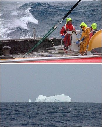
“On the other hand, you don’t want to leave too late into Northern Hemisphere winter,” Cahalan says. “The winter weather in the middle latitudes of the Northern Hemisphere is dominated by low-pressure storm systems that travel from west to east. Once you go around the world and come back through the Atlantic, it is critical to be able to use the northern hemisphere storm track to make good time through the North Atlantic back to England.” If they leave too late in the season, the mid-latitude winter storm pattern may have fizzled out by the time they return.
Being ready to go at a moment’s notice is a pre-requisite for setting out for a trip like the one they were about to undertake. “Timing the launch date is one of the most crucial decisions on the whole trip,” explains Cahalan. “The record at the time was 64 days, and to beat that, we knew we had to reach the equator in under 8 days. We were looking for a forecast that would get us there in that window.”
The window would have to include a northerly wind to push them southward away from England and into the trade winds (a belt of predominantly easterly winds in both hemispheres that blow from about 30 degrees latitude toward the equator). “We were leaving from a town called Plymouth, on the southwest coast of England, about 100 nautical miles from the race start line in the English Channel. It was already the beginning of February, and we starting to worry about getting to the Southern Ocean too late and returning to the Northern Hemisphere when the westerly storm track was gone.”
Cahalan pored over weather reports and briefings from Commander’s Weather, the New Hampshire-based company that the team had hired to provide forecasting support for their voyage. Finally, she says, “We saw a window of good trade winds, and we made a late decision on Friday afternoon to leave for the start line. The weather models predicted this was the last opportunity for several weeks. The problem was that getting to the start line was going to be rough—50 knot winds getting there.
If you aren’t a sailor, you could be excused for thinking that a fifty-knot tailwind sounds like a great stroke of luck. But in a catamaran-type boat like Cheyenne, says Cahalan, “You really want winds of 35 knots maximum.” Anything higher than that and the boat, including the mast and sails, come under a lot of strain, mostly because of the waves that develop. She adds, “Above those speeds, the sailing is very rough, very bumpy.”
On Friday, February 6, Cahalan came aboard with the rest of the crew—the only woman among 12 men. When it came time to leave, the weather was cold and blowing. Cahalan admits saying to herself, “Ohh, I don’t want to go. What am I thinking?” But within a day, they were in the Bay of Biscay west of France. “It was beautiful and sunny.”
The Race is On
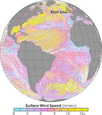
“The general route for these round-the-world races is basically the same for everyone,” explains Cahalan, “because it’s based on the persistent wind belts and calms that are part of the general circulation of the atmosphere.” The general circulation is simply the movement of the atmosphere averaged over a span of time, such as a month, a season, or a year. The patterns repeat so predictably because the underlying factors that drive them either don’t change—for example, the fact that the Earth is spinning or that the equator gets more direct sunlight than the poles—or else change so slowly that they appear unchanging—like the location of the continents.
Cahalan explains it is the major wind belts and calms that sailors are concerned with. “Between the poles and the equator, each hemisphere has three major surface wind belts: the polar easterlies, which extend from the poles to about 60 degrees latitude; the prevailing westerlies, which stretch from about 60 degrees to 35 degrees; and the trade winds, which pick up at about 30 degrees, and blow towards the equator.”
The opposite of these typically windy areas are latitudes where the surface winds—when they exist—are light and unpredictable. One of these calm zones circles the globe between five degrees north and south of the equator, where the trade winds converge. Thunderstorms occur daily, but surface winds are so scarce in the region that the European sailors nicknamed it “the doldrums.” Meteorologists call it the Inter-Tropical Convergence Zone, or ITCZ, for short.
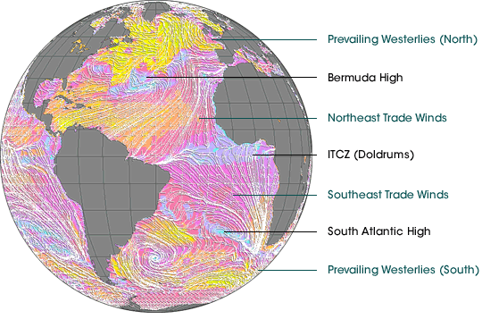
The other areas of predictable calm occur between about 35 and 30 degrees latitude in both hemispheres. These clear-sky, dry areas are called “the horse latitudes,” which may be a grim reference to the days when the crews of ships stranded without wind at those latitudes were forced to either eat their horses or throw them overboard when food and water supplies dwindled.
In the doldrums, there is little surface wind because the trade winds collide and drive air upward. In the horse latitudes, the opposite occurs: air is sinking back down to the surface from high in the atmosphere. Rising air creates zones of low pressure at the surface; sinking air creates zones of high pressure.
In the Atlantic in the northern hemisphere, this region of high pressure at the horse latitudes is called the Bermuda High; in the Atlantic in the southern hemisphere horse latitudes, the region is called the South Atlantic High. Sailors must avoid these matching areas of high pressure and little wind that lurk in the middle of the Atlantic in both Hemispheres.
“Leaving from the English Channel, the route is south along the Bay of Biscay, staying about 80 miles west of the Canary Islands. Next, you aim to cross the Equator somewhere between 25 and 30 degrees West, a place where the ITCZ [the doldrums] is rather thin. Then you go around the South Atlantic High and head toward the Southern Ocean,” explains Cahalan.
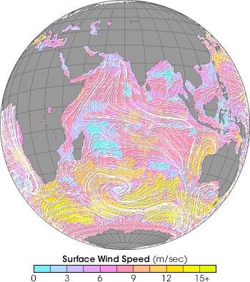
When the Cheyenne reached the Antarctic Convergence Zone—where cold Antarctic waters meet the waters of warmer mid-latitude oceans—Cahalan recalls how quickly conditions changed. “It was amazing how it was like a line in the ocean as far as how strong the differences were in air and water temperature,” she says. “We saw icebergs as far north as 48 degrees South when we were near 60 degrees East. We sailed the rest of the way eastward around the Southern Ocean at about 50 degrees South, dipping a little lower to maybe 53-54 south in the South Pacific.” After crossing the empty Pacific, the Cheyenne sailed around the southern tip of South America and in mid-March, they found themselves once again in the Atlantic.
Atmospheric Tricks and Treats
“Getting up the South Atlantic is quite tricky,” says Cahalan, “even under normal circumstances. The winds just aren’t favorable for sailing northward there. Ken Campbell, the Director of Marine Services at Commander’s Weather, agrees. “When the Cheyenne got to the Falkland Islands, we had to make a decision about how to go north in the South Atlantic. The forecasts were very uncertain, so we decided to be conservative, to just pick the shortest distance and look for little favorable wind shifts up close.”
The winds, however, were anything but favorable. After pushing their way north for thousands of kilometers, they finally reached the latitudes where they should have been able to pick up the southeast trade winds to hurry them back to the equator. But when they got close, the trade winds weren’t there.
“This is where things got really interesting for us,” says Cahalan. “At this point, we are up essentially 24 hours a day, sleeping in 2-hour shifts, just watching the weather, speaking with Commander’s Weather several times a day, trying to find some favorable winds. We had already done a lot of damage to the mast track and sails just from being at sea for so long, and then we began to see squall activity on the horizon—really big clouds ahead. Also, the seaway turned very bad, very choppy, even though there was little wind. So we began to know something was going on ahead.”
Back in New Hampshire, the forecasters at Commander’s Weather were using satellite imagery and other weather information to figure out how to get the Cheyenne back to the equator without the trade winds. “Once we got to about 30 south,” explains Campbell, “we saw a big area of squalls, and of course we didn’t want them to go in the middle of that. So we had to send them around to the west.”
As Cheyenne went west, the squalls to the northeast seemed to be coalescing into a single system. When air is swept high into the atmosphere by thunderstorms, the air pressure at the surface can drop significantly, at least temporarily. Surrounding, higher-pressure air flows into the low pressure core to even things out.

“This effort to balance things out is what normally drives the trade winds—high pressure at the horse latitudes causes air to move toward the equator, where daily thunderstorms create a band of low pressure,” explains Campbell. “But that storm created a large area of low pressure [to the south], so there were no trade winds. We were left in a void.”
Cahalan recalls the updates coming in from Commander’s Weather as the situation with the developing low was changing very quickly. “The forecasters were initially saying, ‘Oh, yeah, by the way, as you know there is a little low out there you’ll have to steer clear of,’ and then it was,‘ Hmm, well, we are seeing some really strong winds,’ and then it was, ‘Wow, it’s spinning pretty good.’,” says Cahalan with a laugh. “Because we had always known it was there and had gone around it, we were far enough west of the storm that we weren’t in any immediate danger from it, but without the trade winds, we were having a hard time getting north.”
Skirting Catarina
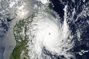
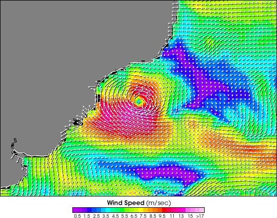
Not everyone was as lucky as the crew of the Cheyenne. Paying no attention to the fact that it was not in “hurricane territory,” between March 20-26, the storm developed a hurricane-looking eye, hurricane-looking clouds, and finally, hurricane-force winds of 92 mph. The storm plowed ashore in the state of Santa Catarina in southern Brazil, killing several people, damaging many vessels in the Brazilian fishing fleet, and destroying thousands of houses.
Although the Cheyenne wasn’t in any immediate danger from the storm that Brazilians eventually named “Catarina,” their world-record pace record was. With the storm interfering with the trade winds, Cheyenne continued to struggle to make northward progress.
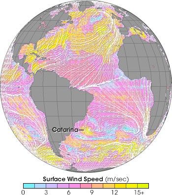
“Finally,” says Cahalan, “we got a break.” At the core of all tropical storms is an area of low air pressure. Air from hundreds, even thousands, of kilometers around flows toward the low-pressure core of the storm. “In the Southern Hemisphere air moves in a clockwise direction around a low,” explains Cahalan. “Since we were west of the storm, we got pushed along by the southerly winds coming around the bottom of the low. We finally picked up the trade winds at about 15 degrees.”
re-crossed the equator on Day 50, and left the tropics behind. “We had a fast ride through the northeast trades and then were fortunate to meet southerly winds associated with an approaching low-pressure system at 20 degrees North.” They rode the coattails of that winter storm almost all the way back to the starting line in the English Channel. After 58 days and nine hours, they arrived where they had begun, beating the previous record by just over five days.
Storm Speculation: Hurricane or Not?
Exhausted, and ten pounds lighter from eating reconstituted food for more than seven weeks, all Cahalan wanted when she returned to England, was a hot shower and sleep. “You come back from these things totally wrecked,” she admits. Still, it didn’t take her long to recover enough to begin making the rounds of her meteorological colleagues to discuss the South Atlantic storm.
With no formal hurricane-monitoring network in place in the South Atlantic, satellites provided the best documentation for the storm. Cahalan pored over black and white images from weather satellites and photo-like images from sensors on NASA’s Terra and Aqua satellites that revealed the size, shape and organization of the storm. Radar observations from the Tropical Rainfall Measuring Mission documented rainfall and cloud vertical structure. Back on land, Cahalan finally had the chance to see from space what she had experienced on the ocean.
“The storm was very controversial,” recalls Cahalan. “Everyone was talking about it, asking ‘How had it started? Was it really a hurricane? Was it a sign of climate change?’” According to NASA meteorologist Jeff Halverson, Catarina was the subject of heated discussions at scientific meetings and conferences in the months following the event, and he suspects atmospheric scientists will be discussing it for a long time. Halverson thinks it’s likely that Catarina was out of the ordinary, but perhaps not unique. “It’s probably not the first storm like it, but it is the first verifiable hurricane-like storm in that region,” he says.
Global Warming or Not?
As to the possibility that the storm is a sign of climate instability or global warming, Halverson says you could never make that case on the basis of a single storm. Some of the speculation is fueled by other unusual happenings in the Atlantic. “In 2003, there was an unusually early start to the hurricane season, with a storm in April. And then in January 2004, there had been another storm in the South Atlantic that appeared to have tropical storm characteristics. And then there was Catarina. So you look at those three events, and that makes people wonder if we are seeing the effect of climate change. But it’s just speculation at this point.”
As for Cahalan, her peripheral encounter with the out-of-place hurricane is just one of the many things she enjoys about being a professional yachtswoman. The chance to experience and learn about unusual weather is part of the joy of being at sea. Cahalan is already thinking of her next event, possibly a round-the-world race with an unusual route—one that begins and ends in Qatar and crosses the equator in the Indian, rather than the Atlantic Ocean. “That area has a totally different meteorology; for that race, the weather is all about the monsoon.” But Cahalan isn’t daunted. She looks forward to the challenge of charting a new course.
Links
NASA Earth Observatory story Rebecca Lindsey; design by Robert Simmon

