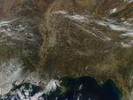

















On March 7, 2007, scores of fires were burning across the southern United States when the Moderate Resolution Imaging Spectroradiometer (MODIS) on NASA’s Aqua satellite passed over head and captured this image. Places where MODIS detected actively burning fires are marked with red dots. Fires are scattered across the country from the plains of southern Oklahoma and Texas to the foothills of the Appalachian Mountains in Georgia. According to the March 11, 2007, summary report from the interagency Southern Area Coordination Center, only a handful of the fires being monitored or combated in the South had been started naturally by lightning; the remainder were caused by people.
The large image provided above has a spatial resolution (level of detail) of 250 meters per pixel. The MODIS Rapid Response Team provides daily images of the region in additional resolutions.
References & Resources
NASA image courtesy the MODIS Rapid Response Team, Goddard Space Flight Center