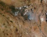


Extreme drought fueled wildfires in New Mexico during June 2013. With fires already burning in northern New Mexico, another intense fire emerged in the southern part of the state in Gila National Forest on June 7, 2013.
Lightning ignited the Silver Fire in a rugged, forested area east of of Silver City, New Mexico. On June 10, 2013, the Moderate Resolution Imaging Spectroradiometer (MODIS) on NASA’s Terra satellite captured this image of the fire. Red outlines indicate hot spots where MODIS detected unusually warm surface temperatures that are associated with fires.
According to firefighting agencies in New Mexico, the Silver Fire had spread across nearly 6,700 acres (2,700 hectares) by by the morning of June 11. The fires were being fought by 350 firefighters on the ground and by helicopters.
An assessment of wildfire vulnerability issued by the National Interagency Fire Center in early June pointed out that much of the New Mexico had received less than half the normal amount of rain in May. About 82 percent of the state was in either extreme or exceptional drought, according to the U.S. Drought Monitor. New Mexico will be at a high risk of wildfire throughout the hot and dry month of June, but wetter conditions should arrive in July when weather patterns shift and the North American monsoon brings more rain to the state.
Further Reading
- Las Cruces Sun-News (2013, June 10) Kingston evacuated as crews battle Silver Fire. Accessed June 11, 2013.
- Silver City Sun-News (2013, June 10) Fire in Black Range closes Highway 152, forces evacuation of Kingston. Accessed June 11, 2013.
References & Resources
- InciWeb (2013, June 11) Silver Fire. Accessed June 11, 2013.
- National Interagency Fire Center (2013, June 1) National Significant Wildland Fire Potential Outlook (pdf). Accessed June 11, 2013.
- NOAA North American Monsoon. Accessed June 11, 2013.
- U.S. Drought Monitor (2013, May 28) Drought Summary: New Mexico. Accessed June 11, 2013.
NASA image courtesy Jeff Schmaltz, LANCE/EOSDIS MODIS Rapid Response Team at NASA GSFC. Caption by Adam Voiland.