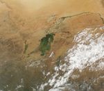



















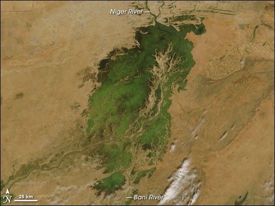
In the middle of Mali, part of the landscape gleams like a giant emerald in the otherwise arid brown African Sahel. The gleaming jewel is the Inland Niger Delta. Fed by floodwaters from the Niger River, the Bani River, and a network of smaller streams, this inland delta grows to some 20,000 square kilometers (7,700 square miles) during the four-month rainy season that begins each July. During the dry season, the inland delta can shrink to roughly 3,900 square kilometers (1,500 square miles).
The Moderate Resolution Imaging Spectroradiometer (MODIS) on NASA’s Terra satellite took this picture of the Inland Niger Delta on November 11, 2007 shortly after the end of the rainy season when the landscape remained lush and green. This inland delta is a complex combination of river channels, lakes, swamps, and occasional areas of higher elevation. One such area of higher elevation is obvious in this image, and it forms a branching shape, like a tan tree pushing up toward the north.
This wet oasis in the African Sahel provides habitat both for migrating birds and West African manatees. The fertile floodplains also provide much needed resources for the local people, who use the area for fishing, grazing livestock, and cultivating rice.
The inland delta has a long history of supporting a human population. Near the southeastern edge of the inland delta lies the town of Djenne, which was founded sometime between 800 and 1250 AD. Just 3 kilometers (2 miles) away lies the remains of Djenne-jeno, or “Old Jenne,” an earlier settlement founded as long ago as 250 BC. Archeological finds indicate that over the next millennia, Djenne-jeno grew to a major urban settlement and trading center.
References & Resources
- Metropolitan Museum of Art. Inland Niger Delta. Accessed November 16, 2007.
- World Wildlife Fund. Inner Niger Delta Flooded Savanna. Accessed November 16, 2007.
- Lange K.E. (2001, June) Djénné: West Africa’s Eternal City. National Geographic. Accessed November 16, 2007.
NASA image courtesy the MODIS Rapid Response Team at NASA GSFC. The Rapid Response Team provides daily images of this region.