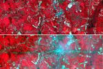


















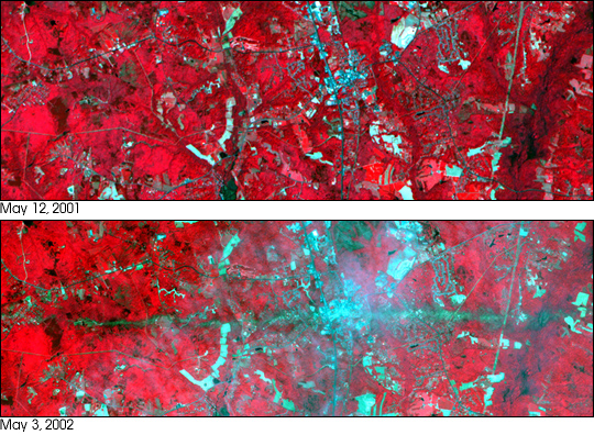
On Sunday, April 28, an F4 tornado cut an east-west path through La Plata, Maryland, killing 3 and injuring more than 100. These two images show a 6 x 17.8 km area centered on the town. The top image was acquired on May 12, 2001, and the bottom on May 3, 2002. The bands used for the image portray vegetation in red, and bare fields and urban areas in blue-green. The dark turquoise swath cutting across the 2002 image is the track of the tornado, where the vegetation was ripped up and removed.
These images were acquired on May 3, 2002, and May 12, 2001 by the Advanced Spaceborne Thermal Emission and Reflection Radiometer (ASTER) on NASA’s Terra satellite. With its 14 spectral bands from the visible to the thermal infrared wavelength region, and its high spatial resolution of 15 to 90 meters (about 50 to 300 feet), ASTER will image Earth for the next six years to map and monitor the changing surface of our planet.
References & Resources
NASA image provided courtesy of METI/ERSDAC/JAROS, and U.S./Japan ASTER Science Team.