


On November 8, 2018, the Camp Fire erupted 90 miles (140 kilometers) north of Sacramento, California. As of 10 a.m. Pacific Standard Time on November 9, the fire had consumed 70,000 acres of land and was five percent contained, or surrounded by a barrier.
The Operational Land Imager on Landsat 8 acquired this image on November 8, 2018, around 10:45 a.m. local time (18:45 Universal Time). The image was created using Landsat bands 4-3-2 (visible light), along with shortwave-infrared light to highlight the active fire. The fire started around 6:30 a.m. Pacific Standard Time, and by 8:00 p.m., it had burned 20,000 acres of land.
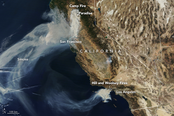
Strong winds pushed the fire to the south and southwest overnight, tripling its size and spreading smoke over the Sacramento Valley. The Moderate Resolution Imaging Spectroradiometer (MODIS) on NASA's Terra satellite captured the natural-color image above on November 9. The High-Resolution Rapid Refresh Smoke model, using data from National Oceanic and Atmospheric Administration (NOAA) and NASA satellites, shows the smoke should continue to spread west. The image also shows two more fires in southern California, the Hill and Woolsey Fires.
More than 2,000 personnel have been sent to fight the Camp Fire, which is predicted to be fully contained by November 30. Firefighters are having difficulty containing it due to strong winds, which fan the flames and carry burning vegetation downwind. The area also has heavy and dry fuel loads, or flammable material.
State and local officials have closed several major highways, including portions of Highway 191. They also ordered evacuations in several towns, including Concow and Paradise, where the fatal fire burned through the town.
References & Resources
- California Department of Forestry and Fire Protection (2018, November 9) Camp Fire Incident Update â AM Accessed November 9, 2018.
- Sacramento Bee (2018, November 9) Five dead in Paradise: Camp Fire consumed their cars as they tried to escape. Accessed November 9, 2018.
- Wildfire Today (2018, November 9) Wildfire Smoke Map. Accessed November 9, 2018.
NASA Earth Observatory image by Joshua Stevens, using Landsat data from the U.S. Geological Survey, and MODIS data from NASA EOSDIS/LANCE and GIBS/Worldview. Story by Kasha Patel.


