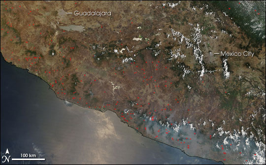
On May 14, 2006, the Moderate Resolution Imaging Spectroradiometer (MODIS) on NASA’s Terra satellite collected this image of numerous fires burning in southern Mexico. The locations of actively burning fires that MODIS detected are marked in red. Thick smoke settles over the Sierra Madre del Sur range at the bottom right of the scene. The “washed out” appearance of the Pacific Ocean in the bottom part of the image is from bright sunlight reflecting directly back to the sensor.
The high-resolution image provided above has a spatial resolution (level of detail) of 250 meters per pixel. The MODIS Rapid Response Team provides daily images of the area in a variety of resolutions and formats.
References & Resources
NASA image courtesy the MODIS Rapid Response Team, Goddard Space Flight Center.