
















Suggested Searches

1 min read

Fires Scorch Oregon

Instruments:
Topics:
2024-07-26 12:00:00
July 26, 2002

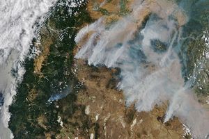
In southwestern Oregon, the Florence Fire (large cluster of red pixels at upper left) and the Sour Biscuit Fire (to the south) continue to burn virtually out of control on July 26, 2002. Numerous evacuations notices have been issued for residents in the area as the fires remain difficult to control due to the steep, rugged terrain of the Klamath Mountains. This image was acquired by the Moderate Resolution Imaging Spectroradiometer (MODIS) on the Terra satellite.

References & Resources

Image by Jesse Allen, based on data from MODIS Land Rapid Response Team at NASA GSFC

You may also be interested in:

Stay up-to-date with the latest content from NASA as we explore the universe and discover more about our home planet.

Fighting Fire With Fire
3 min read

In fire-prone ecosystems in Australia's Northern Territory, prescribed burns are lit to minimize the severity of fires later in the…

Article
Smoke Streams Across Eastern Washington
3 min read

Wildland fires in early August 2026 pushed air quality to unhealthy levels, destroyed hundreds of structures, and triggered mandatory evacuations…

Article
Smoke Blankets Oregon
3 min read

Lightning storms have ignited dozens of fires in central and eastern Oregon.

Article