

March 26, 2015-March 21, 2019
Floods and Landslides in Chimanimani
Tropical Cyclone Idai barreled into southern Africa on March 15, 2019, leaving a deadly path of destruction. Rains, winds, and a storm surge thrashed coastal and central areas of Mozambique. Farther inland in eastern Zimbabwe, flooding and landslides have drastically altered the landscape.
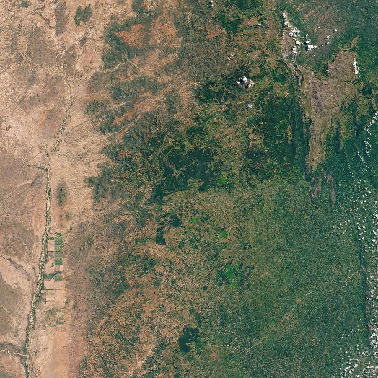
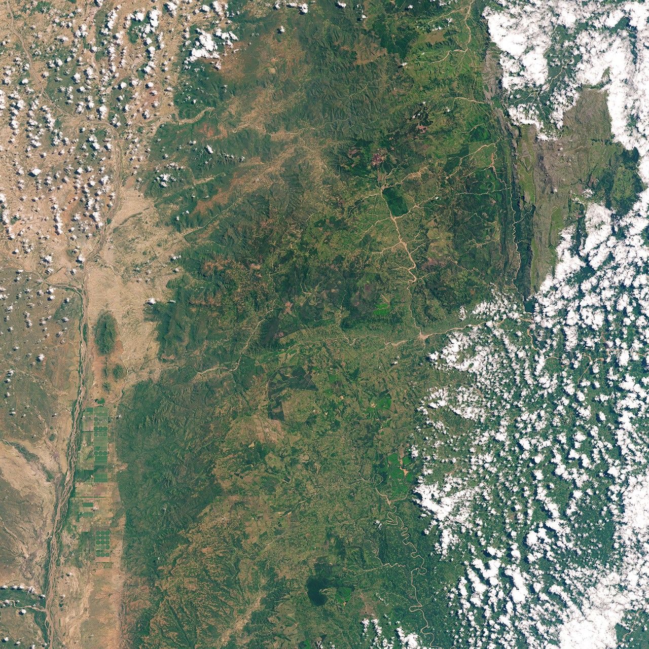
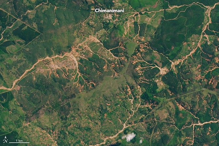
According to reports from the International Charter, Zimbabwe’s most affected area was the Chimanimani District—a mountainous area close to the border with Mozambique. Widespread changes are visible in these images from before and after the storm; the Operational Land Imager (OLI) on Landsat 8 acquired the images.
The right image shows the area around Chimanimani on March 21, 2019, one week after the cyclone. Rivers appeared swollen with muddy water, branching into places where water was not visible in March 2015 (left image). There are also signs of numerous landslides flowing into the rivers.
“While many of the individual events were not particularly large, the mobilization of debris and regolith material from many small events clearly overwhelmed the rivers and led to extensive debris flows,” said Robert Emberson, a researcher with the landslides team at NASA’s Goddard Space Flight Center. “These are more likely to cause damage and affect infrastructure in areas farther downstream from the landslides themselves.”

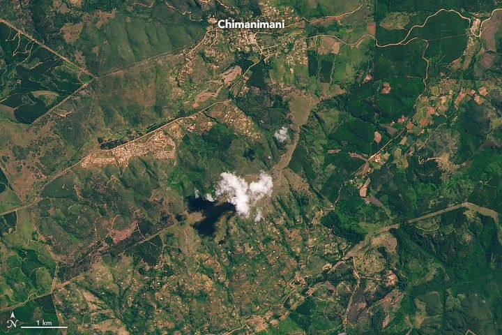
The second image pair shows a particularly distinct landslide in Chimanimani National Park about 13 kilometers (8 miles) northeast of Chimanimani. The red color of the slide area indicates weathered soils that more easily slide during intense rainfall events.
Rainfall totals in Zimbabwe were not as high as in coastal and Central Mozambique, but they were still higher than usual for the region and likely contributed to the prevalence of landslides, according to Emberson. The terrain was also a factor. “The area around Chimanimani has much greater topographic relief and slope than the flat coastal plain, and thus is much more susceptible to landsliding,” he said.
By March 25, the cyclone’s death toll continued to climb as aid efforts were ongoing, according to news reports.
“This was an unusual event,” Emberson said. “This part of Africa does not often receive large tropical cyclones, so local people may not be aware of the landslide risk associated with these once-in-a-generation events.”
References & Resources
- AGU: The Landslide Blog (2019, March 21) Planet Labs imagery of landslides in Chimanimani National Park, Zimbabwe, triggered by Cyclone Idai. Accessed March 25, 2019.
- AGU: The Landslide Blog (2019, March 20) Cyclone Idai: evidence of the impact of landslides and debris flows. Accessed March 25, 2019.
- CNN (2019, March 25) Cyclone Idai: Death toll rises to 750 as Mozambique city of Beira begins long road to recovery. Accessed March 25, 2019.
- The International Charter Space and Major Disasters (2019, March 16) Cyclone Idai in Zimbabwe. Accessed March 25, 2019.
- NASA Earth Observatory (2019, March 22) Devastation in Mozambique.
- NASA Earth Observatory (2019, March 13) Tropical Cyclone Idai Aims at Mozambique.
- NASA Earth Observatory (2017, April 6) Overlooked Landslides.
- Reliefweb (2019, March 24) UNICEF Zimbabwe Humanitarian Situation Report (Cyclone Idai) 24 March 2019. Accessed March 26, 2019.
- The Washington Post (2019, March 18) In photos: Cyclone Idai lays waste to parts of Mozambique, Zimbabwe, Malawi. Accessed March 25, 2019.
NASA Earth Observatory images by Joshua Stevens, using Landsat data from the U.S. Geological Survey. Story by Kathryn Hansen with image interpretation by Caroline Juang/NASA GSFC, and Robert Emberson/NASA GSFC.