Suggested Searches

1 min read

Guinea-Bissau


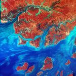
Guinea-Bissau is a small country in West Africa. Complex patterns can be seen in the shallow watersalong its coastline, where silt carried by the Geba and other rivers washes out into the AtlanticOcean.

This image was acquired byLandsat 7’s Enhanced Thematic Mapper plus(ETM+) sensor on January 12, 2000. This is a false-color composite image made using infrared, red,and blue wavelengths to bring out details in the silt.

References & Resources

Image provided by the USGS EROS Data Center Satellite Systems Branch
You may also be interested in:

Stay up-to-date with the latest content from NASA as we explore the universe and discover more about our home planet.

Painting the Growing Season in the Maize Triangle
3 min read

Radar data from an agricultural area in South Africa, shown in a vivid color palette, reveal crop types and how…

Article
Wild, Scenic, and Increasingly Rusty
5 min read

Orange streams are now being spotted in hundreds of watersheds in permafrost areas throughout Alaska’s Brooks Range.

Article
A Tide-Fueled Trove of Biodiversity in Guinea-Bissau
3 min read

The expansive mudflats, sandy beaches, and mangrove forests of the Bijagós archipelago support an array of migratory shorebirds and large…

Article