- Movie file (mpeg) format (553 kB)
- Quicktime (.mov) format (1.2 MB)
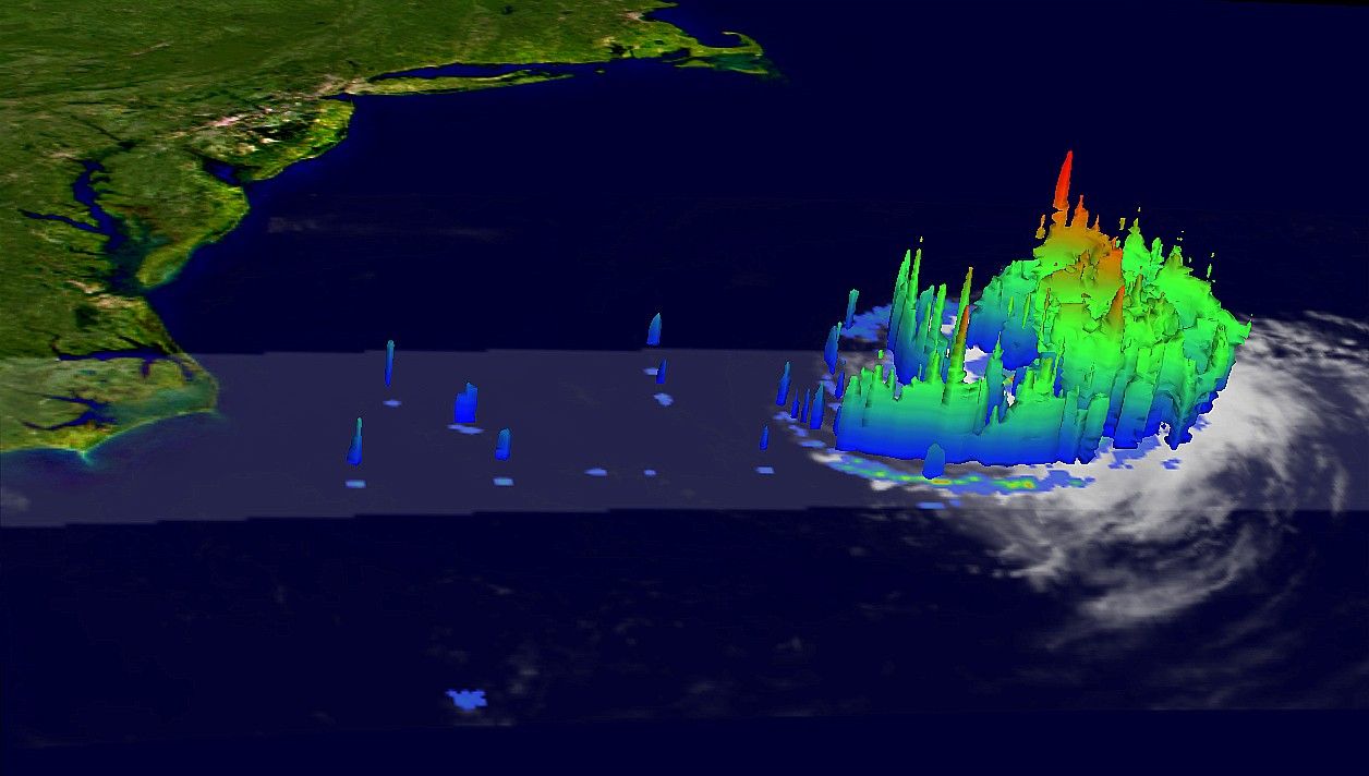
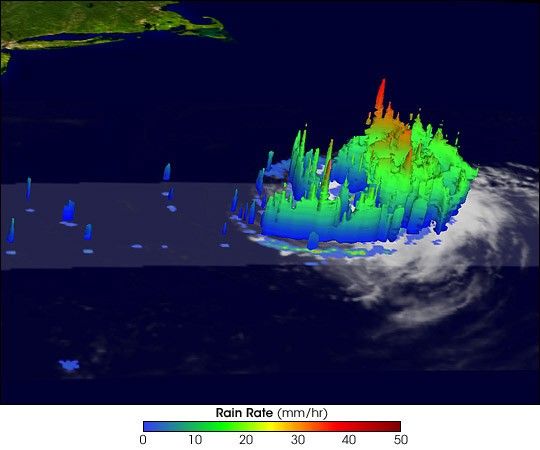
Just as Irene strengthened into a hurricane, it veered north and east, sparing the east coast of the United States. Irene continued the record-fast pace of the 2005 Atlantic hurricane season, becoming the earliest 9th named storm, well before peak season in September. Irene was also a Cape Verde storm, like Emily, originating west of the Cape Verde Islands in the central Atlantic. Storms typically do not form this far east so early in the season because water temperatures in the region are not usually warm enough. However, this part of the Atlantic has been much warmer than normal early in the season.
This image, captured by the Tropical Rainfall Measuring Mission (TRMM) satellite on August 15, 2005, at 1:43 a.m. EDT (05:43 UTC), shows Irene just after it became a hurricane. The image shows the height of rain columns within the hurricane. Tall rain columns provide a clue that the storm is strengthening. As water vapor rises, it cools and condenses into rain, releasing heat. It is this heat that feeds the storm. The higher water vapor rises before cooling, the more intense the storm tends to be. In this image, the highest towers, the tallest of which reaches about 17 kilometers into the atmosphere, produce the heaviest rain, shown in red. Since these towers are like pistons that convert energy from water vapor into a powerful wind-and-rain-producing engine, high towers can be a sign of future strengthening. Indeed, not long after this image was taken, Irene’s winds intensified to 150 kilometers per hour (90 mph) on August 15.
Since its launch in 1997, TRMM has been providing valuable images and information on hurricanes and tropical cyclones over the Tropics. In this image, rain rates are from the TRMM Precipitation Radar (PR), the only radar capable of measuring rainfall from space.
TRMM is a joint mission between NASA and the Japanese space agency JAXA.
References & Resources
Images produced by Hal Pierce (SSAI/NASA GSFC) and caption by Steve Lang (SSAI/NASA GSFC).