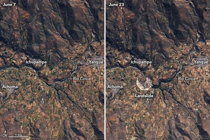
As residents of Peru’s Achoma district slept on June 16, 2020, the earth around them was stirring with activity. At approximately 1:40 a.m., soil and rock on a hillside slipped loose and created a massive landslide. When residents woke up, at least 40 hectares (200 acres) of nearby farmland was destroyed. The landslide also created a natural dam along the Rio Colca and caused flooding in the valley.
The images above show a portion of Colca Valley on June 7 and June 23, 2020, before and after the landslide. The images were acquired by the Operational Land Imager (OLI) on Landsat 8. The earthen dam created by the landslide is reported to be almost 50 meters (160 feet) high.
According to the Geophysical Institute of Peru (IGP), the landslide was the result of unstable terrain and did not have seismic (earthquake) origins. The Geological, Mining, and Metallurgical Institute (INGEMMET) reported that the landslide debris was loose sediments mixed in layers of sand and water-saturated silt and clay. IGP’s National Seismological Center recorded small tremors as the stones and soil settled later.
The landslide damaged the farmland of nearly 70 families. The land had been used for raising dairy cattle, as well as growing potatoes, peas, corn, quinoa, and alfalfa.
More than two kilometers of the Colca river channel also flooded, according to news media. Authorities are concerned that the flooding could cause additional landslides and weaken the base of the Cervantes Colonial Bridge, triggering a collapse. The water has already covered the Chacapi thermal baths, a popular tourist attraction in the Yanque district.
The Peruvian government declared states of emergency for the Achoma and Ichupampa districts for 60 days. Authorities were attempting to drain the water with motor pumps while working remove the earthen dam.
References & Resources
- AGU Landslide Blog (2020, June 30) The 18 June 2020 Achoma landslide in Peru. Accessed July 2, 2020.
- Diario Correo (2020, June 28) With 10 motorized pumps they will unload the dam in the Colca river. Accessed July 2, 2020.
- Geological, Mining, and Metallurgical Institute (2020, June 22) INGEMMET Records Impressive Images of the Slip in Achoma and Determines that the area affected is 40 hectares. Accessed July 2, 2020.
- La República (2020, June 19) Alert in the Colca valley: landslide causes the river reservoir. Accessed July 2, 2020.
- Peru Space AgencyâNational Commission for Aerospace Research and Development (2020, June 21) PeruSAT-1 captures landslide in Caylloma, Arequipa. Accessed July 2, 2020.
- Radio Programas del Perú (2020, June 18) Arequipa: A hill collapses in the Colca valley and causes damming of a river. Accessed July 2, 2020.
- Radio Programas del Peru´ (2020, June 30) Arequipa: More than two kilometers of the Colca river bed are flooded. Accessed July 2, 2020.
NASA Earth Observatory images by Joshua Stevens , using Landsat data from the U.S. Geological Survey . Story by Kasha Patel .