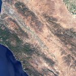



























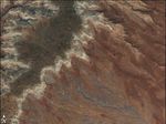

Steep rocky crags and towering cliffs rise out of the Gabilan Mountains east of Salinas Valley in Central California. Called Pinnacles National Monument, the landscape was formed as wind, water, and earthquakes carved away a 23-million-year-old volcano. The region was set aside as a National Monument on January 16, 1908, and now encompasses 24,514 acres.
The park’s rugged landscape gives this Landsat-7 image a wrinkled appearance. The plants that grow in this arid region are brown from the summer heat. Most of these plants are chaparral, plants adapted to arid climates, but pine and oak forests and grasslands also grow in the monument. The region has hot, dry summers with cool winters in which moderate rain falls. During the winter and spring rains, the mountains are green, dotted with wildflowers in the spring. When the rains stop, the region quickly turns brown. This image was taken on June 19, 2001, well after the end of the rainy season.
References & Resources
NASA image created by Jesse Allen, Earth Observatory, using data provided courtesy of the University of Maryland’s Global Land Cover Facility .