


Popocatépetl is one of Mexico’s most active volcanoes. During the mountain’s current period of eruption, ongoing since 2005, volcanic emissions frequently billow from its summit crater. In spring 2023, striking plumes were captured in images acquired by satellites and astronauts, both orbiting hundreds of kilometers above Earth’s surface.
The Operational Land Imager (OLI) on Landsat 8 acquired this image (above) on April 14, 2023. Monitoring systems on that day detected water vapor, volcanic gases, and ash, according to Mexico’s National Center for Disaster Prevention (CENAPRED).
The volcano still puffed on May 2, 2023, when an astronaut on the International Space Station took this photograph (below). It shows a wider view of the region that includes Iztaccihuatl—a dormant volcanic mountain—and the nearby town of Puebla. Mexico City (not pictured) is about 70 kilometers (40 miles) northwest of Popocatépetl.
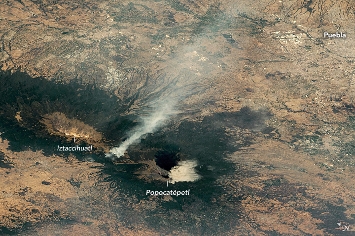
The source of the other plume, located between the two volcanoes, is unclear based on this photograph. Past research has suggested that satellite-detected hotspots on the volcano’s slopes could be due to fire. Also notice the green vegetated areas surrounding the peaks. Conifer forests and high-mountain prairies are an important part of the area’s ecosystem.
Around the time of these images, volcanic plumes rose as high as 7.3 kilometers (24,000 feet), according to the Washington Volcanic Ash Advisory Center. As of May 4, the volcanic alert level remained yellow (the middle level of a three-color scale).
References & Resources
- Marchese, F. et al. (2019) A Multi-Channel Algorithm for Mapping Volcanic Thermal Anomalies by Means of Sentinel-2 MSI and Landsat-8 OLI Data. Remote Sensing, 11(23), 2876.
- Mexico’s National Center for Disaster Prevention (CENAPRED) (2023, May 2) CENAPRED monitoring report to the Popocatépetl volcano today May 2, 2023. Accessed May 4, 2023.
- Mexico’s National Center for Disaster Prevention (CENAPRED) (2023, April 14) CENAPRED monitoring report to the Popocatépetl volcano today April 14, 2023. Accessed May 4, 2023.
- Smithsonian Institution, Global Volcanism Program (2023, May 2) Popocatépetl. Accessed May 4, 2023.
- Volcano Discovery (2023, May 4) Popocatépetl Volcano. Accessed May 4, 2023.
- The Yucatan Times (2023, March 7) Impressive eruption of the Popocatepetl volcano caught on video. Accessed May 4, 2023.
NASA Earth Observatory image by Lauren Dauphin, using Landsat data from the U.S. Geological Survey . Astronaut photograph ISS069-E-8304 was acquired on May 2, 2023, with a Nikon D5 digital camera using an 400 millimeter lens and is provided by the ISS Crew Earth Observations Facility and the Earth Science and Remote Sensing Unit, Johnson Space Center. The image was taken by a member of the Expedition 69 crew . The image has been cropped and enhanced to improve contrast, and lens artifacts have been removed. The International Space Station Program supports the laboratory as part of the ISS National Lab to help astronauts take pictures of Earth that will be of the greatest value to scientists and the public, and to make those images freely available on the Internet. Additional images taken by astronauts and cosmonauts can be viewed at the NASA/JSC Gateway to Astronaut Photography of Earth . Story by Kathryn Hansen .


