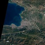
While not detailed enough to reveal earthquake damage to houses and buildings, this regional view of Port-Au-Prince, Haiti, on January 15, 2010, illustrates some of the physical obstacles that have complicated the job of aid workers in the aftermath of the recent earthquake along the Enriquillo-Plaintain Garden Fault south of the city.
The capital city is densely populated and densely built, with little open space apparent amid the gray pavement and buildings. With debris filling the streets, it has been difficult for supply trucks to maneuver, according to news reports. The single port through which large cargo ships can approach the city (image center) has been damaged, and the city’s only landing strip (top right) was overwhelmed by the number of flights trying to land and take off.
This image was acquired by the Advanced Land Imager (ALI) on NASA’s Earth Observing-1 (EO-1) satellite.
References & Resources
NASA Earth Observatory image created by Jesse Allen, using EO-1 ALI data provided courtesy of the NASA EO-1 team. Caption by Rebecca Lindsey.