


Long-term drought is straining water resources in South Texas. Levels in two large reservoirs that supply the Corpus Christi area have declined steadily for the past several years, with further declines expected in the coming years. Residents and businesses have faced restrictions on outdoor water usage since December 2024, and city officials project that a water emergency requiring additional restrictions could occur by the end of 2026.
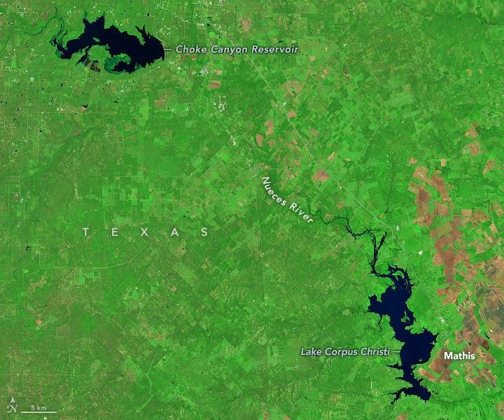
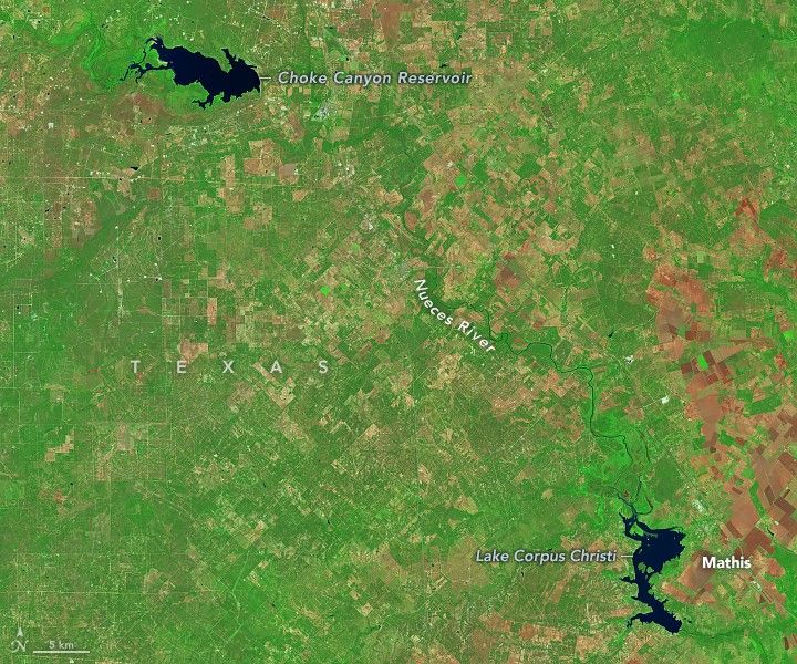
The images above show the change in Choke Canyon Reservoir and Lake Corpus Christi between October 2021 (left) and October 2025 (right). They were acquired with the OLI (Operational Land Imager) on Landsat 8 and the OLI-2 on Landsat 9, respectively, and are false color (OLI bands 7-5-4) to emphasize the presence of water.
Water levels in both reservoirs trended downward in the four years between the images. Ground-based gauge data indicate that Choke Canyon Reservoir went from 47 percent to 11 percent full between October 2021 and October 2025, while Lake Corpus Christi declined from 87 percent to 14 percent of capacity. The gauge data were compiled by the U.S. Geological Survey Oklahoma-Texas Water Science Center and published by the Texas Water Development Board.


In mid-October 2025, the U.S. Drought Monitor reported that 60 percent of the Corpus Christi area was experiencing moderate or severe drought conditions, up slightly from the same time the previous year. According to the National Weather Service, year-to-date rainfall totals through October in Corpus Christi were less than 60 percent of normal.
Restrictions for residents and businesses began in mid-December 2024, when the combined capacity of Choke Canyon Reservoir and Lake Corpus Christi dropped below 20 percent. This prompted the city to implement Stage 3 water restrictions, disallowing the watering of lawns and limiting other outdoor water usage to certain days and times.
Based on current water supply models, officials project that the city of Corpus Christi may need to declare a water emergency as early as November 2026. The emergency stage is initiated 180 days before water demand is expected to exceed supply in the two reservoirs. If declared, mandatory reductions could extend to industrial and high-volume water users, in addition to residents and businesses, according to the city’s drought contingency plan.
As of November 17, 2025, the two reservoirs held a combined 10.8 percent capacity. However, some of that water may have limited usability due to high sediment loads that risk damaging filtration and treatment systems, officials said. City managers are working on a range of measures to supplement the water supply, from digging wells to purchasing groundwater rights.
NASA Earth Observatory images by Michala Garrison, using Landsat data from the U.S. Geological Survey. Story by Lindsey Doermann.
References & Resources
- City of Corpus Christi Drought Status Stage 3. Accessed November 17, 2025.
- City of Corpus Christi (2025, October 31) Water Supply Dashboard. Accessed November 17, 2025.
- City of Corpus Christi (2024, December 16) Corpus Christi Now Under Stage 3 Water Restrictions. Accessed November 17, 2025.
- E&E News (2025, October 27) Water shortage threatens Texas refining hub. Accessed November 17, 2025.
- National Weather Service (2025) South Texas Drought Page. Accessed November 3, 2025.
- NBC News (2025, September 27) In South Texas, a town struggles for water. Accessed November 17, 2025.
- Texas Water Development Board (2025) Choke Canyon Reservoir. Accessed November 17, 2025.
- Texas Water Development Board (2025) Lake Corpus Christi. Accessed November 17, 2025.


