


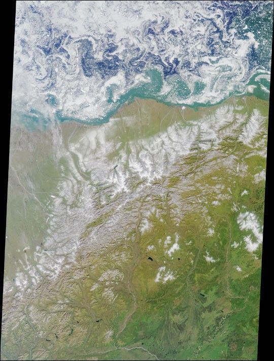
This colorful image of the Arctic National Wildlife Refuge and theBeaufort Sea was acquired by the Multi-angle Imaging SpectroRadiometer’snadir (vertical-viewing) camera on August 16, 2000. The swirling patterns apparent on the Beaufort Sea are small icefloes driven by turbulent water patterns, or eddies, caused by theinteractions of water masses of differing salinity and temperature. Bythis time of year, all of the seasonal ice which surrounds the northcoast of Alaska in winter has broken up, although the perennial pack iceremains further north. The morphology of the perennial ice pack’s edgevaries in response to the prevailing wind. If the wind is blowingstrongly toward the perennial pack (that is, to the north), the ice edgewill be more compact. In this image the ice edge is diffuse, and thepatterns reflected by the ice floes indicate fairly calm weather.
The Arctic National Wildlife Refuge (often abbreviated to ANWR) wasestablished by President Eisenhower in 1960, and is the largest wildliferefuge in the United States. Animals of the Refuge include the130,000-member Porcupine caribou herd, 180 species of birds from fourcontinents, wolves, wolverine, polar and grizzly bears, muskoxen, foxes,and over 40 species of coastal and freshwater fish. Although most ofANWR was designated as wilderness in 1980, the area along the coastalplain was set aside so that the oil and gas reserves beneath the tundracould be studied. Drilling remains a topic of contention, and an energybill allowing North Slope oil development to extend onto the coastalplain of the Refuge was approved by the US House of Representatives onAugust 2, 2001.
The Refuge encompasses an impressive variety of arctic and subarcticecosystems, including coastal lagoons, barrier islands, arctic tundra,and mountainous terrain. Of all these, the arctic tundra is thelandscape judged most important for wildlife. From the coast inland toan average of 30-60 kilometers, arctic tundra dominates the coastalplain, until reaching the foothills of the Brooks Mountain Range.Beneath the tundra, a layer of permafrost reaches an average depth of600 meters, restricting water drainage through the soil, and increasingthe sensitivity of tundra vegetation to disturbance. Precipitation isscarce (less than 16 centimeters per year) and the small amount of meltwater or rain that soaks into the tundra remains near the surface. Thisis why the coastal plain can be classified as a wetland.
The western boundary of the Refuge is marked by the Canning River,about halfway between the center and left-hand side of the image, andthe eastern boundary is near the right-hand edge at the US/Canadianborder. The two permanent human settlements within the image area areKaktovic near the tip of the large rounded peninsula, and Arctic Villagesouth of the Brooks Range near the southern Refuge boundary. The arearepresented by the image is approximately 380 kilometers x 540kilometers.
References & Resources
Image courtesy NASA/GSFC/LaRC/JPL, MISR Team.


