


August 19, 2014
The Aral Sea Loses Its Eastern Lobe
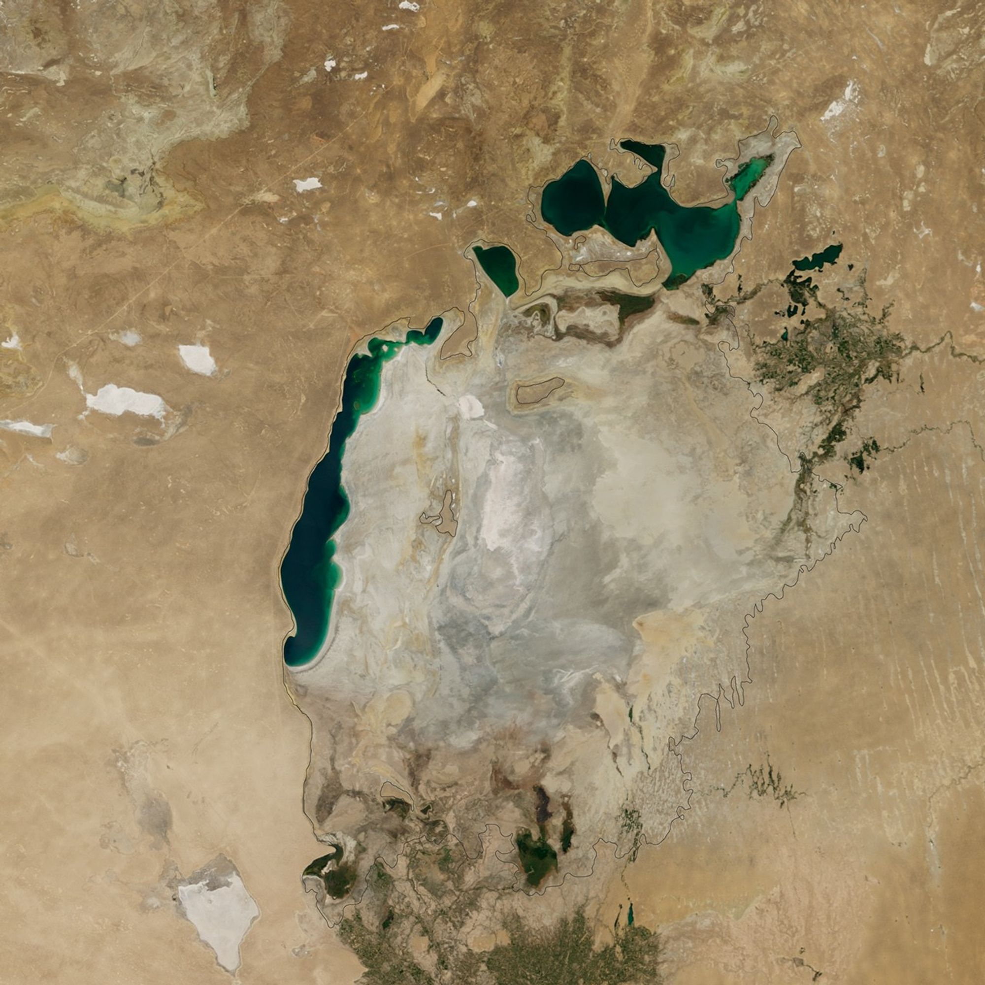
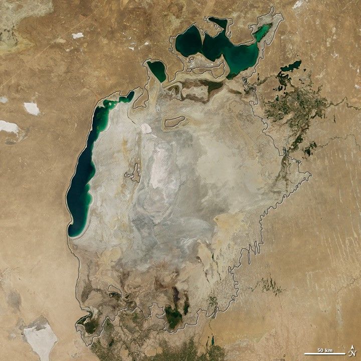
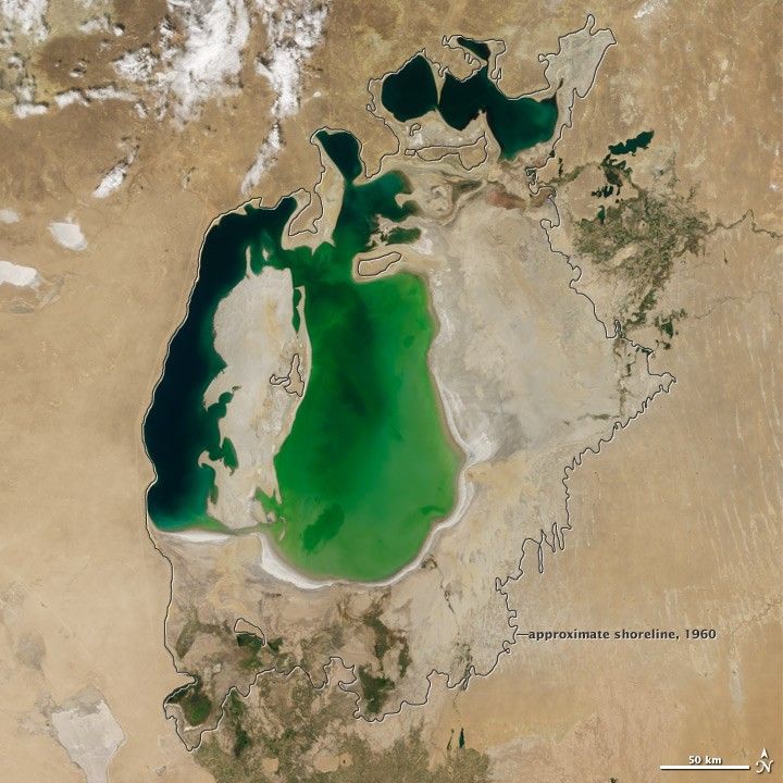
Summer 2014 marked another milestone for the Aral Sea, the once-extensive lake in Central Asia that has been shrinking markedly since the 1960s. For the first time in modern history, the eastern basin of the South Aral Sea has completely dried.
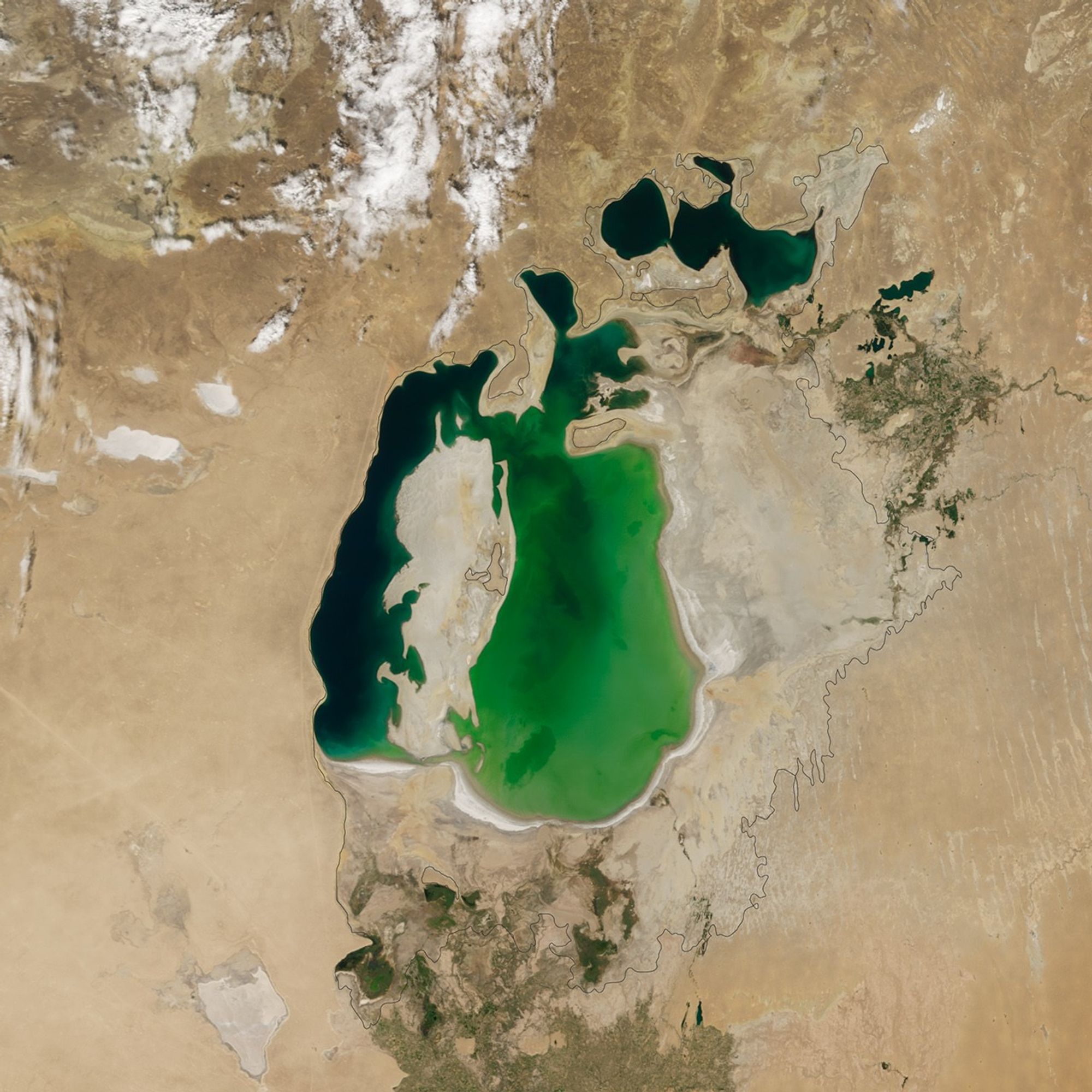
This image pair from the Moderate Resolution Imaging Spectroradiometer (MODIS) on NASA's Terra satellite shows the sea without its eastern lobe on August 19, 2014 (top). Substantial changes are apparent when compared to an image from August 25, 2000 (bottom), and again when compared to the approximate location of the shoreline in 1960 (black outline).
"This is the first time the eastern basin has completely dried in modern times," said Philip Micklin, a geographer emeritus from Western Michigan University and an Aral Sea expert. "And it is likely the first time it has completely dried in 600 years, since Medieval desiccation associated with diversion of Amu Darya to the Caspian Sea."
In the 1950s and 1960s, the government of the former Soviet Union diverted the Amu Darya and the Syr Darya—the region's two major rivers—to irrigate farmland. The diversion began the lake's gradual retreat. By the start of the Terra series in 2000, the lake had already separated into the North (Small) Aral Sea in Kazakhstan and the South (Large) Aral Sea in Uzbekistan. The South Aral had further split into western and eastern lobes.
The eastern lobe of the South Aral nearly dried in 2009 and then saw a huge rebound in 2010. Water levels continued to fluctuate annually in alternately dry and wet years.
According to Micklin, the desiccation in 2014 occurred because there has been less rain and snow in the watershed that starts in the distant Pamir Mountains; this has greatly reduced water flow on the Amu Darya. In addition, huge amounts of river water continue to be withdrawn for irrigation. The Kok-Aral Dam across the Berg Strait—a channel that connects the northern Aral Sea with the southern part—played some role, but has not been a major factor this year, he said.
"This part of the Aral Sea is showing major year-to-year variations that are dependent on flow of Amu Darya," Micklin said. "I would expect this pattern to continue for some time."
References and Further Reading
- NASA Earth Observatory (2012, February 24) The Aral Sea, Before the Streams Ran Dry. Accessed September 25, 2014.
- NASA Earth Observatory (2006, April 11) Aral Sea Expansion. Accessed September 25, 2014.
- NASA Earth Observatory (2000, August 25) World of Change: Shrinking Aral Sea. Accessed September 25, 2014.
- Micklin, P. (2010, September) The past, present, and future Aral Sea. Lakes & Reservoirs: Research & Management, 15 (3), 193. Accessed September 25, 2014.
References & Resources
NASA Earth Observatory image by Jesse Allen, using data from the Level 1 and Atmospheres Active Distribution System (LAADS). Caption by Kathryn Hansen.