

Early on April 27, 2014, a cold front from the Rocky Mountains descended on the Plains, fueling intense thunderstorms that spun out a powerful tornado. Beginning at 7 p.m., the twister cut a swath of destruction through the small towns of Mayflower and Vilonia, Arkansas. Sixteen people were killed and 400 to 500 homes were destroyed.
A day later, the Moderate Resolution Imaging Spectroradiometer (MODIS) on NASA’s Aqua satellite detected evidence of the damage—a faint brown trail across the otherwise green landscape north of Little Rock. Since MODIS was designed to monitor broad swaths of Earth’s surface every day, its top resolution of 250 meters (820 feet) per pixel does not offer much detail. But on May 2, NASA’s Advanced Land Imager (ALI) on Earth Observing-1 (EO-1) passed over Arkansas and offered a much clearer view of the damage.
At MODIS resolution, the entire town of Mayflower is barely distinguishable; but at ALI’s top resolution of 10 meters per pixel, it is possible to distinguish between individual buildings. In this ALI image, a trail of damaged trees and homes is visible near Interstate 40. The storm moved in a northeasterly direction, hitting the southern part of Mayflower first, then crossing I-40, and flattening neighborhoods along the shore of Lake Conway. The aerial image below, taken by meteorologists from the National Weather Service’s Little Rock office, shows damaged homes along Lake Conway.
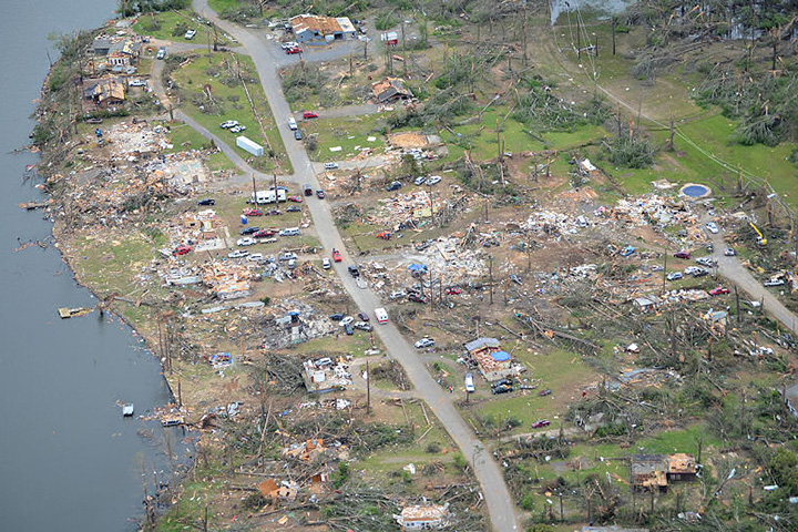
The tornado left a 41-mile (66 kilometer) trail of destruction. It was classified with an EF4 rating on the Enhanced Fujita Scale, meaning it had winds that were between 267-322 kilometers (166-200 miles) per hour.
References & Resources
- Actual ABD News (2014, April 28) Mayflower, Arkansas Tornado 27 April 2014. Accessed May 5, 2014.
- CIMSS Satellite Blog (2014, April 27) Blowing dust in the central Plains, and a severe weather outbreak in the southern Plains and Lower Mississippi River Valley regions. Accessed May 5, 2014.
- National Weather Service, Little Rock (2014, April 28) Tornadoes/Flooding on April 27-28, 2014. Accessed May 5, 2014.
- NBC News (2014, April 28) Tornado Survivor in Mayflower, Ark., Describes Terror. Accessed May 5, 2014.
- The Weather Channel (2014, April 29) Arkansas Tornadoes: ‘Utter Devastation’, 15 Deaths Reported. Accessed May 5, 2014.
NASA Earth Observatory image by Jesse Allen and Robert Simmon, using EO-1 ALI data provided courtesy of the NASA EO-1 team. Caption by Adam Voiland.