


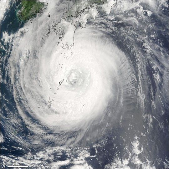
NASA’s Terra satellite captured this true-color image of Typhoon Chaba on August 29, 2004, at 1:45 UTC. At the time Chaba was located approximately 537 km (334 miles) south-southeast of Sasebo, Japan, and was moving towards the west-northwest at 15 km/hr (9 mph). Maximum sustained winds were near 194 km/hr (121 mph) with higher gusts to 241 km/hr (150 mph). Chaba means ‘hibiscus’ in Thai, and the storm does have an awesome beauty as it swirls in the Pacific south of Japan.
Chaba is the third powerful tropical storm to hit Japan in the last two weeks, as first Typhoon Megi, then Typhoon Aere, and finally Chaba churned through the region. At least five people were killed in Japan when Chaba came ashore, and tens of thousands have evacuated their homes in Kyushu and Shikoku as the heavy rain from the storm continues to pose a risk for flooding and landslides. Hundreds of thousands of people were without power, and trains and other transportation have been severely disrupted.
References & Resources
Image courtesy Jacques Descloitres, MODIS Land Rapid Response Team at NASA GSFC


