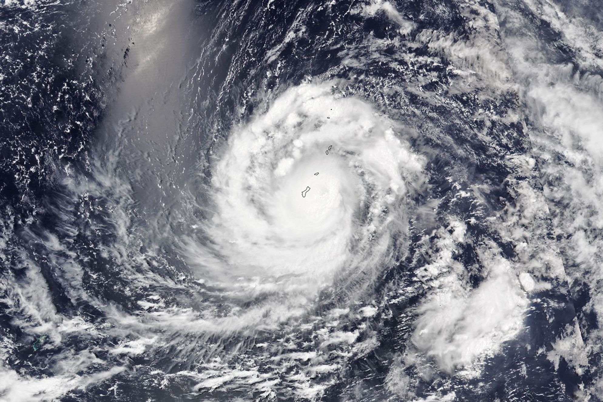


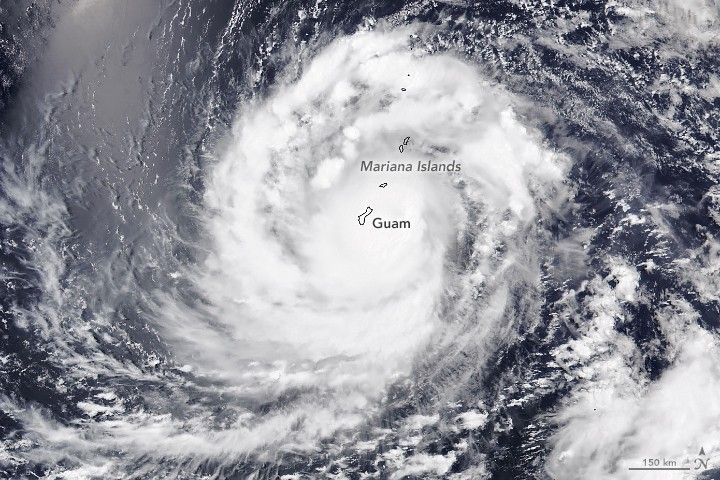
In late May 2023, a potent typhoon spun toward the Mariana Islands in the North Pacific Ocean. The storm, named Typhoon Mawar, was one of the strongest in decades to lash the U.S. territory of Guam, according to news reports.
The Visible Infrared Imaging Radiometer Suite (VIIRS) on the NOAA-20 satellite acquired this image at 1:50 p.m. local time (03:50 Universal Time) on May 24, 2023, as Mawar approached Guam. At the time, the storm carried sustained winds of about 140 miles (225 kilometers) per hour—equivalent to a category 4 storm on the Saffir-Simpson wind scale.
The image shows the typhoon’s cloud bands completely covering the islands, which were already being lashed with powerful winds and heavy rain. (The bright area in the top-left of the image is sunglint—an optical phenomenon unrelated to the storm.)
The typhoon maintained its category 4 strength as the storm’s center traversed the Rota Channel, between the islands of Guam and Rota, at about 9 p.m. local time on May 24. The eye’s southern wall passed over much of Guam, according to the U.S. National Weather Service, and delivered the most extreme winds to the northern-third of the island.
On May 25, the typhoon moved west-northwest and away from the islands. The full extent of storm damage in Guam remained unclear, but early reports indicated widespread power outages, downed trees, and coastal flooding. U.S. officials declared an emergency in the region on May 22, authorizing disaster relief efforts.
New data could soon help scientists learn more about tropical cyclones like Mawar. The final launch of NASA’s Time-Resolved Observations of Precipitation structure and storm Intensity with a Constellation of Smallsats (TROPICS) mission is targeted for no earlier than 12 a.m. Eastern Time on May 25. The shoebox-sized satellites are designed to collect information about temperature, precipitation, water vapor, and clouds—data that can provide insight into storm formation and intensification.
References & Resources
- AP News (2023, May 24) Typhoon Mawar flips cars, cuts power on Guam as scope of damage emerges in US Pacific territory. Accessed May 24, 2023.
- Joint Typhoon Warning Center (2023, May 24) JTWC Tropical Warnings. Accessed May 24, 2023.
- NASA Earth Observatory (2002, December) Super Typhoon Pongsona. Accessed May 24, 2023.
- NASA Small Satellite Missions (2023, May 21) TROPICS Launch Now Targeting May 25. Accessed May 24, 2023.
- National Public Radio (2023, May 24) Climate change makes Typhoon Mawar more dangerous. Accessed May 24, 2023.
- National Public Radio (2023, May 24) A typhoon just lashed Guam. What does federal relief look like for a U.S. territory? Accessed May 24, 2023.
- National Weather Service (2023, May 24) NWS Forecast Office - Tiyan, Guam. Accessed May 24, 2023.
- The New York Times (2023, May 21) Typhoon Mawar Heads Toward Guam With Force of Category 4 Hurricane. Accessed May 24, 2023.
- The White House (2023, May 23) The White House. Accessed May 24, 2023.
NASA Earth Observatory image by Allison Nussbaum, using VIIRS data from NASA EOSDIS LANCE , GIBS/Worldview , and the Joint Polar Satellite System (JPSS). Story by Kathryn Hansen .