


Landsat 10 Mission Details
Mission Objectives
Under the Sustainable Land Imaging (SLI) Program, Landsat 10 will continue the long-running partnership between NASA and the USGS by acquiring high-quality, space-borne, medium-resolution global land imaging data. The Landsat 10 mission has four major objectives:
- Collect and archive medium-resolution (10-60m), reflective and emissive multispectral image data affording seasonal coverage of the global land mass for a period of no less than five years.
- Ensure that data are sufficiently consistent with data from earlier Landsat missions in terms of spectral and spatial characteristics, acquisition rates, geometry, calibration, product quality, and data availability.
- Support critical emerging user needs and applications, as characterized by periodic assessments and identified by operational requirements.
- Distribute data products to the public in a timely and dependable manner on a nondiscriminatory, unrestricted basis.
An Innovative Mission Concept
Landsat 10 is an innovative mission concept that will continue the Landsat program’s legacy of global land imaging with finer spatial resolution and richer spectral information. The mission reflects both advances in technology, in part through the NASA Sustainable Land Imaging-Technology (SLI-T) program, and user application priorities for land monitoring, as reflected in the following key documents:
The key elements of the Landsat 10 concept include:
- Continuation of the Landsat legacy through sustainable mission operations.
- Collection of bands with higher spatial resolutions, ranging from 10 to 60 meters, for improved detection, monitoring, and management.
- Acquisition of 26 spectral bands to support Landsat data continuity,
Sentinel-2 compatibility, and emerging applications.
- Preservation of spatial, geometric, and radiometric requirements to maintain long-term data consistency and ensure high-quality science products.
- Collection of reflective and thermal infrared bands within 15 seconds of each other to allow for band-to-band georegistration and accurate observations.
- Development of the Worldwide Reference System-3 (WRS-3) based on the updated orbital parameters.
- Implementation of new techniques to increase the efficiency of ground system operations and improve the distribution of data products.
A New Worldwide Reference System
Landsat 10 will occupy a sun-synchronous orbit at an altitude of 653 kilometers (406 miles), have an inclination of ~98 degrees, and image the ground track at the equator at 10:10 am ± 5 minutes (mean local time at descending node). At a slightly lower altitude than previous Landsat satellites, Landsat 10 achieves a global minimum of 18-day temporal revisit given the stringent field-of-view requirements of the Landsat record. Images, or scenes, acquired by the former Landsat missions were cataloged and referenced using Worldwide Reference System (WRS) grids (WRS-1 and WRS-2).
To accommodate the Landsat 10 repeating ground track and global revisit cycle, a new global grid reference system called WRS-3 was established to acquire, catalog, and distribute Landsat 10 scenes. Preserving the previous global reference system and heritage view angle geometry was considered less critical to the overall Landsat 10 mission architecture, since science applications are increasingly moving from scene- to pixel-based analysis using BRDF-normalized data.
Under WRS-3, global acquisitions will be completed in 265 orbits (or paths), compared to the 233 orbits associated with WRS-2. The orbits are numbered sequentially with path numbers increasing from east to west. The row indexing system will be the same as WRS-2, with the orbital paths being segmented into 248 equally spaced scene centers based on lines of latitude, but the swath size will be slightly narrower. The rows are indexed so that the numbers of the descending (daytime) path increase in the along-track direction.
The number of unique ground tracks means that adjacent tracks are approximately 151 kilometers (94 miles) apart at the equator. Therefore, the minimum swath width, after adding 10 kilometers for ground track error and 3 kilometers for margin, is 164 kilometers (102 miles). The along-track scene length, which includes a combined 3% in-track overlap with adjacent scenes, is 168 kilometers (104 miles).
Improved Spatial Resolutions
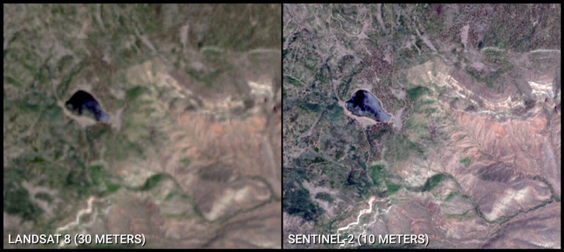
A user needs survey (Wu et al., 2019) revealed that Landsat reflective and thermal infrared emission band data could be better optimized and harmonized with Sentinel-2 data by increasing the spatial resolution of bands for future Landsat missions. Finer spatial resolutions better characterize surface features and dynamics, particularly in heterogenous landscapes with complex structural and compositional variability, such as those in urban environments and coastal ecosystems. They also facilitate the detection and mapping of smaller features, such as woodlots, streams, riparian corridors, and agricultural fields.
Landsat 10 will collect all 26 spectral bands at improved spatial resolutions, with ground sample distances (GSD) of 10 to 20 meters for the visible to shortwave-infrared (VSWIR) bands and 60 meters for the atmospheric and thermal-infrared (TIR) bands. Five fundamental bands, including Red 2, Green, Blue, near-infrared (NIR) Broad, and shortwave-infrared (SWIR) 1, will have a GSD of 10 meters. These bands will facilitate considerable advancements in land cover mapping and enable the calculation of spectral indices (e.g., NDVI, NDMI, MSAVI, SAVI, NDSI) with finer spatial resolutions.
Enhanced Spectral Capabilities
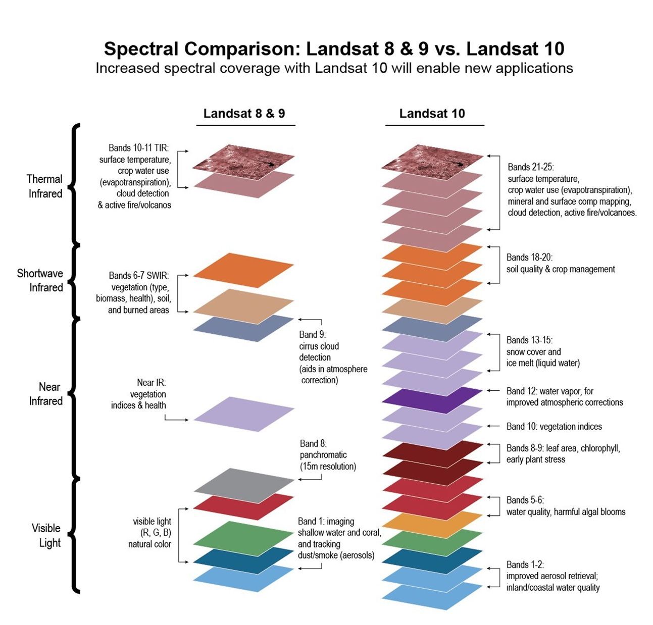
Over the course of five decades, the number of spectral bands acquired by Landsat sensors has increased as technological advancements have been made. Landsat 1, with its Multispectral Scanner (MSS), collected four broad visible and near-infrared (NIR) bands. Landsat 8 and Landsat 9 each acquire 11 spectral bands with their Operational Land Imager (OLI) and Thermal Infrared Sensor (TIRS) instruments. The addition of new bands, including thermal emission bands, with each successive generation of Landsat satellites has supported novel and emerging scientific applications and permitted a greater understanding of global ecosystems and processes, all while maintaining the long-term “heritage” bands to ensure consistency with data from earlier missions.
Landsat 10’s 26 superspectral bands reflect user needs for data continuity and new sources of Earth observation data to address emerging challenges in land, water, and climate science. These enhanced capabilities are made possible by recent advances in instruments, sensors, and observatory components. “Superspectral” refers to a greater number of bands than the previous multispectral Landsat missions. Similar to former Landsat missions, the bands were preselected by the user community based on science needs and previous laboratory, field, airborne, or space-based studies, and were carefully aligned to minimize absorption by the atmosphere (i.e., bands are located in “atmospheric windows”).
Landsat 10 will acquire refined versions of the 11 Landsat “heritage” bands, which includes subdividing broad broads for emerging applications and adding TIR bands for temperature and emissivity separation. To support synergy and data fusion with Sentinel-2 data, Landsat 10 includes five new bands with similar spatial and spectral characteristics. Ten new spectral bands will support evolving and emerging applications, including detection of harmful algal blooms (HABs); snow/ice grain size retrieval and monitoring of melt dynamics; and quantification of crop residue and non-photosynthetic vegetation for agricultural management and soil conservation. An infrared water vapor band was also added to retrieve total column water vapor and remove residual atmospheric absorption and scattering effects in Landsat image data without requiring ancillary data from other Earth observing satellites.
| BANDS | GSD (m) | WAVE-LENGTH RANGE (nm) | RATIONALE | |
|---|---|---|---|---|
| 1 | Violet | 60 | 402 - 422 | Aerosol retrieval, atmospheric correction, detection of colored dissolved organic matter |
| 2 | Coastal/Aerosol | 20 | 433 - 453 | Landsat heritage, Sentinel-2 synergy, vegetation health and plant vigor assessments |
| 3 | Blue | 10 | 457.5 - 522.5 | Landsat heritage, Sentinel-2 synergy, bathymetry, soil/vegetation mapping, detection of snow impurities |
| 4 | Green | 10 | 542.5 - 577.5 | Landsat heritage, Sentinel-2 synergy, vegetation health and plant vigor assessments |
| 5 | Yellow | 20 | 585 - 615 | Detection of leaf chlorosis and vegetation stress, aquatic health and water quality assessments |
| 6 | Orange | 20 | 610 - 630 | Aquatic Phycocyanin (cyanobacteria) detection |
| 7 | Red 1 | 20 | 640 - 660 | Landsat heritage, phycocyanin flourescence (cyanobacteria) detection, chlorophyll content mapping |
| 8 | Red 2 | 10 | 650 - 680 | Landsat heritage, Sentinel-2 synergy, chlorophyll content and vegetation mapping, vegetation differentiation |
| 9 | Red Edge 1 | 20 | 697.5 - 712.5 | Sentinel-2 synergy, leaf area index mapping, chlorophyll content and plant stress mapping |
| 10 | Red Edge 2 | 20 | 732.5 - 747.5 | Sentinel-2 synergy, leaf area index mapping, chlorophyll content and plant stress mapping |
| 11 | NIR Broad | 10 | 784.5 - 899.5 | Sentinel-2 synergy, 10 meter NDVI, biomass content and shoreline detection |
| 12 | NIR 1 | 20 | 855 - 875 | Landsat heritage, Sentinel-2 synergy, biomass content and shoreline detection |
| 13 | Water Vapor | 60 | 935 - 955 | Sentinel-2 synergy, atmospheric correction for land surface temperature, surface reflectance |
| 14 | Liquid Water | 20 | 975 - 995 | Liquid water and water surface state detection, vegetation water content mapping |
| 15 | Snow/Ice 1 | 20 | 1025 - 1045 | Snow grain size mapping |
| 16 | Snow/Ice 2 | 20 | 1080 - 1100 | Ice absorption, snow grain size mapping |
| 17 | Cirrus | 60 | 1360 - 1390 | Landsat heritage, Sentinel-2 synergy, detection of cirrus (high-altitude) clouds |
| 18 | SWIR 1 | 10 | 1565 - 1655 | Landsat heritage, Sentinel-2 synergy, detection of non-photosynthetic vegetation, fuel moisture mapping |
| 19 | SWIR 2a | 20 | 2025.5 - 2050.5 | Cellulose/crop residue mapping |
| 20 | SWIR 2b | 20 | 2088 - 2128 | Landsat heritage, cellulose/crop residue and soil moisture content mapping, fire scar detection |
| 21 | SWIR 2c | 20 | 2191 - 2231 | Landsat heritage, cellulose/crop residue and soil moisture content mapping, fire scar detection |
| 22 | TIR 1 | 60 | 8175 - 8425 | ASTER synergy, mineral and surface composition mapping |
| 23 | TIR 2 | 60 | 8425 - 8775 | ASTER synergy, emissivity separation, volcano/sulfur dioxide emissions mapping |
| 24 | TIR 3 | 60 | 8925 - 9275 | ASTER synergy, mineral and surface composition mapping |
| 25 | TIR 4 | 60 | 11025 - 11575 | Landsat heritage, surface temperature retrieval, carbonate mineral mapping |
| 26 | TIR 5 | 60 | 11725 - 12275 | Landsat heritage, surface temperature retrieval, snow grain size and moisture content mapping |
Landsat is the gold standard calibration reference because the Landsat program has committed to world-class radiometric and geometric calibration standards.
Julia A. Barsi
NASA Landsat Calibration Scientist
Robust Radiometric and Geometric Performance
The Landsat program has an extensive historical record of highly calibrated data and has served as a gold standard of global land imaging for more than five decades. These elevated standards have permitted time-series analyses and quantitative assessments; enabled the development of higher-level science products; and supported commercial and international sectors through cross-sensor calibration. Rigorous calibration and correction methods have also been applied to provide consistency to a time series that was acquired through different atmospheric conditions using eight different instruments with slightly different spatial, spectral, and view angle characteristics.
The Landsat 10 mission will continue the vision of calibration and validation associated with the Landsat program. Radiometric requirements will be aligned with Landsat 8 and Landsat 9 heritage bands, and georegistration requirements will be adjusted to match the finer GSD of Landsat 10 bands.
The radiometric requirements for Landsat 10 include:
- Signal-to-noise ratios (SNR) matching Landsat 9 when aggregated to 30-meter pixels
- <5% absolute error in at-sensor radiance; <3% in reflectance
- TIR absolute radiometric accuracy 1% at normal Earth temperatures
- <1% VSWIR radiometric change during any WRS-3 cycle (<2% TIR)
The geometric requirements for Landsat 10 include:
- Sub-pixel accuracy in band-to-band registration to support multispectral analysis
- <30 meter absolute geodetic error (CE90) before ground control
- <8 meter geometric error (CE90) after ground control and terrain compensation
To ensure band-to-band alignment and allow accurate cloud screening and science data product generation, each Landsat 10 Instrument Suite (LandIS) will acquire all bands for a scene within a 15-second period. Band-to-band co-registration will be 2, 3, and 6 meters for the 10-, 20-, and 60-meter solar reflective bands, respectively, and 15 meters between the reflective and TIR bands.
Landsat, with its five-decade record of robust collection, calibration, and archiving, and its longstanding service as a global reference to cross-calibrate other missions, improves not only the quality of those systems but the overall quality of the global 'system of systems'.
Kevin T. Gallagher
USGS Associate Director Core Science Systems
Data Volumes, Storage, and Computing
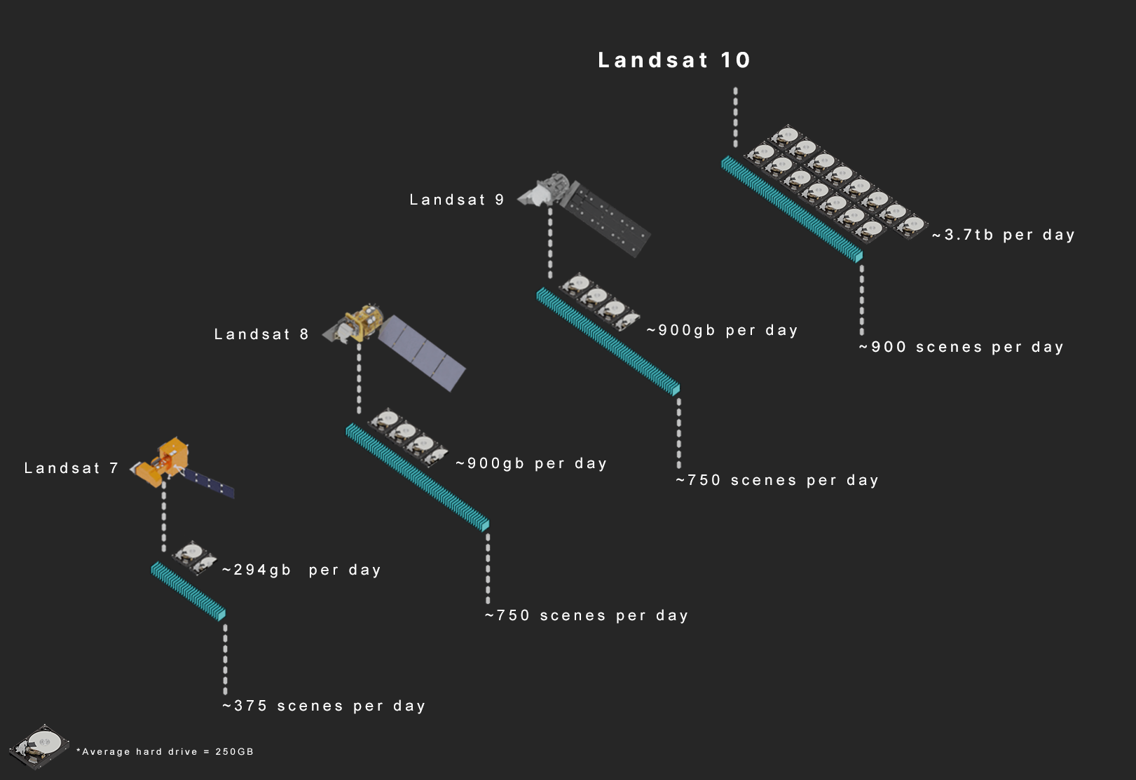
Landsat 10 will collect an estimated 740 scenes per day. With each scene measuring 164 kilometers by 168 kilometers. Landsat 10 reflective bands will have 14-bit depth and thermal bands will have 12-bit depth. Given these specifications, compressed Level-1 Landsat 10 data products are estimated to be 3.7 gigabytes per scene. This increased data volume will add 2.7 terabytes of data to the Landsat archive each day.
Data numbers and calculations – USGS EROS Center (Linda Owen and Esad Micijevic).