Stratospheric Aerosol and Gas Experiment (SAGE) I
Overview
The Stratospheric Aerosol and Gas Experiment I (SAGE I) was launched February 18, 1979, aboard the Applications Explorer Mission-B (AEM-B) satellite. SAGE I was a sun photometer that used solar occultation to measure aerosols and important stratospheric gases in the atmosphere. SAGE I collected valuable data for nearly three years until the power system on the satellite failed.
SAGE I measured the profile of stratospheric aerosol extinction coefficient, ozone, and nitrogen dioxide. That data is still used globally in the study of trends, atmospheric dynamics and transport, and potential climatic effects.
While SAGE I was active, it provided the scientific community with a global depiction of the distribution of stratospheric aerosol extinction coefficient at visible and near infrared wavelengths, ozone and nitrogen dioxide. Using these models of distribution, SAGE I contributed unique and crucial input to the understanding of global, seasonal and inter-annual variability in climate and, in particular, trends in stratospheric ozone. SAGE I is a predecessor to the SAGE III Mission, which is continuing the valuable research of the SAGE Program.
Instrument
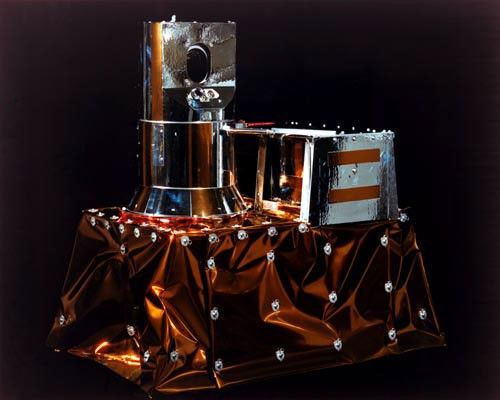
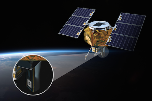
The SAGE I instrument was a four-channel Sun photometer that used a Cassegraninian telescope, holographic grating, and four silicon photodiodes to define the four-spectral-channel bandpass.
Solar radiation was reflected off a scan mirror into the telescope, with an image of the Sun being formed at the focal plane. The instrument’s instantaneous field of view, defined by the aperture on the focal plane, was a 20 arc-sec circle that produced a vertical resolution at the tangent point of about 0.5 km.
Radiation passing through the aperture was transferred to the spectrometer section of the instrument which contained the holographic grating and four separate detector systems. The holographic grating dispersed the incoming radiation into the four spectral regions centered at wavelengths of 1000, 600, 450 and 385 nm. Slits on the Rowland circle of the grating defined the spectral bandpass of the four spectral channels — 50, 30 20, and 30 nm, respectively.
The entire imaging and spectrometer system was inside the azimuth gimbal to allow the instrument to be pointed at the Sun without image rotation. The azimuth gimbal could be rotated over 360° so that the measurements could be made at any azimuthal angle.
The operation of the instrument, during each sunrise and sunset measurement, was totally automatic. Prior to each sunrise or sunset, the instrument was rotated in azimuth to its predicted solar acquisition position. When the Sun entered the instrument’s field of view, the instrument adjusted its azimuth position to lock onto the radiometric center of the Sun to within +/- 45 arc-sec and then acquired the Sun by rotating its scan mirror to the proper election angle. As the Sun traversed between the horizon and tangent height of 150 km, the elevation mirror scanned vertically across the solar disk.
Data Access
Spatial / Temporal Coverage
Spatial Coverage: 80N to 80S, 180E to 180W
Spatial Resolution: Aerosol profiles have a vertical resolution of 1km, from 0.5km or cloud top to 40.5km
Temporal Coverage: 02/21/79 – 11/18/1981
Temporal Resolution: Twice per orbit for durations varying from 3-10 minutes
Data Products
Ozone
Aerosol Extinction Profiles
Nitrogen Dioxide
Get SAGE I data from the Atmospheric Science Data Center
Science Team
SAGE I Science Team Members:
M. Pat McCormick, Hampton University (Previously NASA Langley Research Center)
Gerald W. Grams, Georgia Institute of Technology
Benjamin M. Herman, University of Arizona
Theodore J. Pepin, University of Wyoming
Phillip B. Russell, SRI International Science
Derek M. Cunnold, Massachusetts Institute of Technology
David Murcray, University of Denver
D.E. Miller, British Meteorological Office
Walter G. Planet, National Environmental Satellite Service
Richard A. Craig, Florida State University
Mission Status
The AEM-2 spacecraft experienced power problems after May 15, 1979. However, the spacecraft operations continued until November 19, 1981 (providing a data set of approximately 2.5 years). The signal from the spacecraft was last received on January 7, 1982, when the battery failed. On April 11, 1989, the spacecraft decayed in the atmosphere.
The SAGE instrument detected and tracked also five volcanic eruption plumes that penetrated the stratosphere. It determined the amount of new material each volcano added to the stratosphere. (Mount St. Helens, for example, contributed about 0.5 x 10⁶ metric tons for a 100% enhancement in background stratospheric aerosol mass).