


UARS
Upper Atmosphere Research Satellite
Type
Earth Orbiter
Launched
September 12, 1991
Objective
Study Earth's upper atmosphere
Decommissioned
December 14, 2005
Key UARS Facts
- Orbit Type: Non-Sun-synchronous
- Inclination: 57°
- Altitude: 585 km
- Period: 96.7 minutes
- Dimensions: ~11 m × ~4.5 m
- Mass: 5896.7 kg
- Design Life: 3 years (operated for 14)
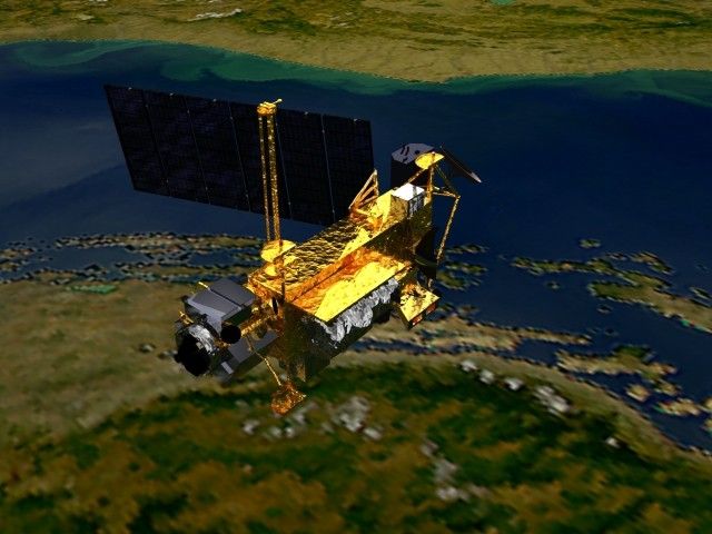
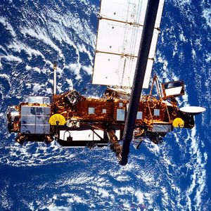
The Upper Air Research Satellite (UARS) was an orbital observatory launched from the payload bay of the Space Shuttle Discovery (STS-48) on September 15, 1991. As implied by the mission’s name, the objective was to carry out a more systematic and comprehensive study of the upper atmosphere than had been completed to date. Ten UARS instruments (see list below) provided the most complete dataset on upper-atmospheric energy inputs, winds, and chemical composition ever gathered at the time. Together, these observations facilitated a highly integrated investigation of the nature of the upper atmosphere, and of Earth’s protective stratospheric ozone layer in particular, which helped to define the role of the upper atmosphere in climate and climate variability. While theories existed about the mechanisms that controlled polar ozone depletion prior to UARS, there had been no way to validate them with data. Despite the design life of only three years, five out of ten instruments onboard UARS (i.e., HALOE, HRDI, PEM, SOLSTICE, and SUSIM) continued to operate into 2005, when the spacecraft was decommissioned.
UARS observations allowed scientists to gain a better understanding of the energy input, chemistry, and dynamics of the stratosphere and mesosphere. UARS focused on the processes that lead to ozone depletion, complementing the measurements of total ozone made earlier by the Total Ozone Mapping Spectrometer onboard Nimbus-7 and the Russian Meteor-3 satellites. UARS also measured winds and temperatures in the stratosphere, as well as the energy input to the Earth system from the Sun, research that was used to improve Earth system models and helped scientists better understand the forces behind global climate change. Some of the measurements UARS began have continued with EOS Aura like the Microwave Limb Sounder measuring ozone and other molecules that are important to ozone chemistry.
UARS Instruments
Four UARS instruments were devoted to measuring constituents, spectroscopically determining the concentrations of many different chemical species and deriving the variation of atmospheric temperature with altitude by observing infrared emissions from carbon dioxide. These are:
- Cryogenic Limb Array Etalon Spectrometer (CLAES)
- Halogen Occultation Experiment (HALOE)
- Improved Stratospheric and Mesospheric Sounder (ISAMS)
- Microwave Limb Sounder (MLS)
Two instruments, utilizing high-resolution interferometry, measure upper-atmosphere winds by sensing the Doppler shift in light absorbed by, or emitted from, atmospheric molecules. These are:
- High Resolution Doppler Imager (HRDI)
- Wind Imaging Interferometer (WINDII)
Four additional instruments obtained estimates of the energy incident on the atmosphere by measuring solar ultraviolet radiation and the flux of charged particles from Earth’s magnetosphere. These are:
- Active Cavity Radiometer Irradiance Monitor II (ACRIM II)
- Particle Environment Monitor (PEM)
- Solar Stellar Irradiance Comparison Experiment (SOLSTICE)
- Solar Ultraviolet Spectral Irradiance Monitor (SUSIM)
Data Access
Archived data from UARS are available through the Goddard Earth Sciences Data and Information Center (GES DISC). The key datasets fall into four broad categories:
- Atmospheric Chemistry/Dynamics: Data from HALOE, MLS, and other instruments, with Level 2 and 3 products detailing ozone and other species.
- Winds and Temperature: Data from HRDI and WINDII instruments measuring mesospheric and stratospheric wind components.
- Solar Irradiance: Data from SUSIM and SOLSTICE, including solar spectral irradiance and Oxygen Schumann-Runge cross-sections.
- Particle Environment: PEM Level 3TP data.
To learn more about UARS data visit the UARS page on the EarthData website.
References
- “The Earth Observing Legacy of NASA’s Space Shuttle Program,” The Earth Observer, Sep–Oct 2011 [23:5, 4–17]. UARS was launched from the Space Shuttle and is described on page 12 of this article.
UARS Stories

The Upper Air Research Satellite (UARS) launched from the payload bay of the Space Shuttle Discovery (STS-48) to undertake a…
Twenty years ago this month, astronauts on the space shuttle Discovery used the spacecraft's robotic arm to launch the Upper…
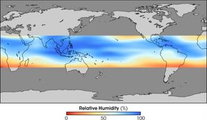
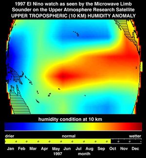
Using instruments aboard NASA’s Upper Atmosphere Research Satellite(UARS), scientists measured humidity high in the atmosphere.
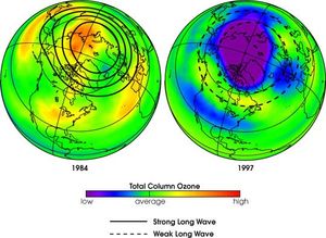
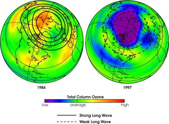
NASA researchers using 22 years of satellite-derived data have confirmed a theory that the strength of “long waves,” bands of…
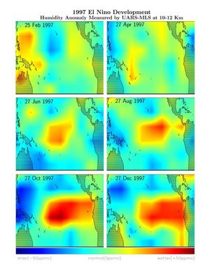
This series of six images shows the evolution of atmospheric water vapor over the Pacific Ocean during the 1998 El…
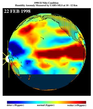
This image shows differences in atmospheric water vapor relative to a normal (average) year in the Earth's upper troposphere about…
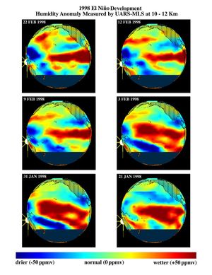
This series of six images shows the movement of atmospheric water vapor over the Pacific Ocean during the formation of…
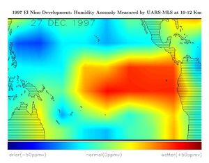
This image shows differences in atmospheric water vapor relative to a normal (average) year in the Earth's upper troposphere about…
This image shows atmospheric water vapor in Earth's upper troposphere, about 10 kilometers (6 miles) above the surface, as measured…


